MyTopo
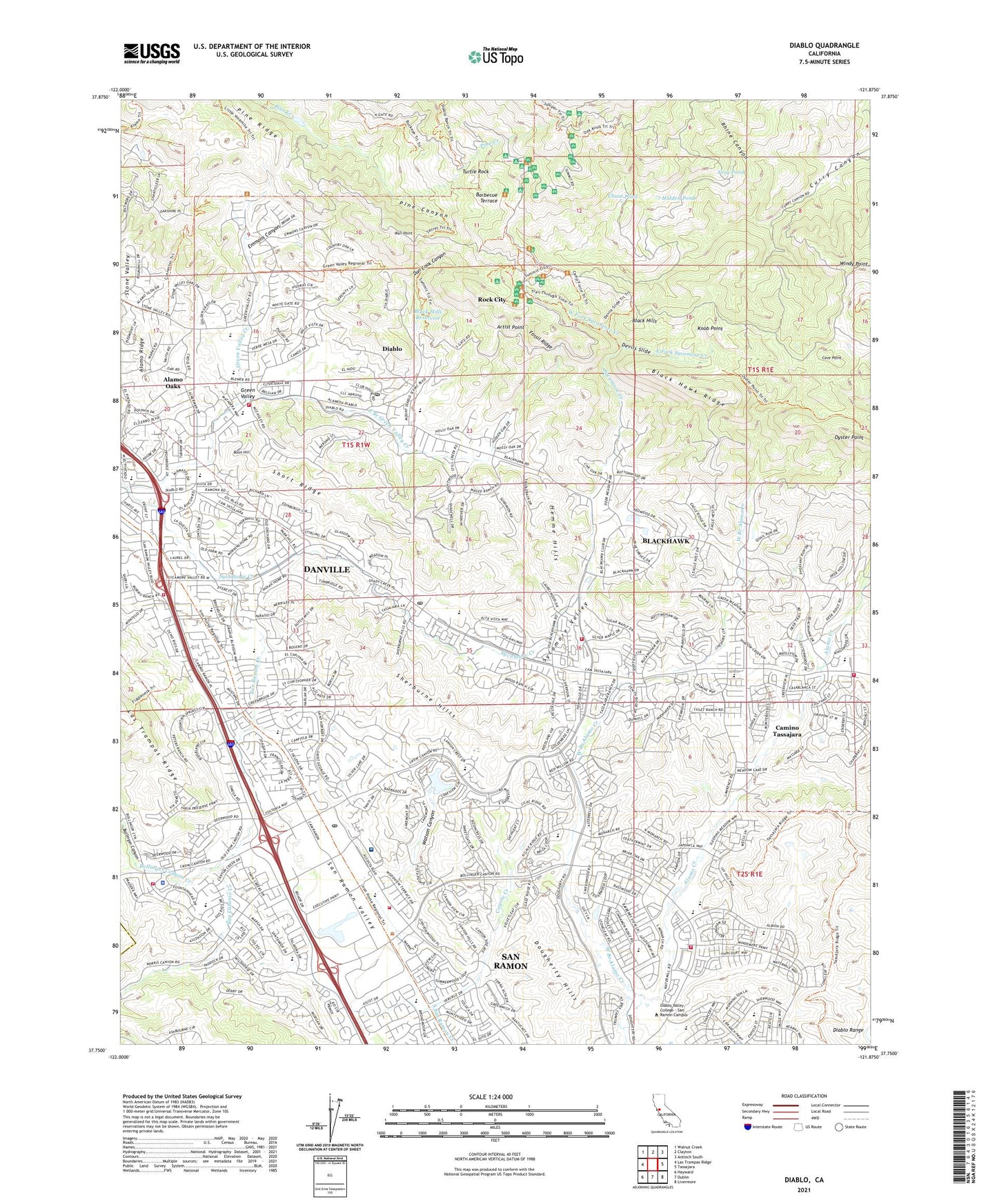
Diablo California US Topo Map
Couldn't load pickup availability
2021 topographic map quadrangle Diablo in the state of California. Scale: 1:24000. Based on the newly updated USGS 7.5' US Topo map series, this map is in the following counties: Contra Costa, Alameda. The map contains contour data, water features, and other items you are used to seeing on USGS maps, but also has updated roads and other features. This is the next generation of topographic maps. Printed on high-quality waterproof paper with UV fade-resistant inks.
Quads adjacent to this one:
West: Las Trampas Ridge
Northwest: Walnut Creek
North: Clayton
Northeast: Antioch South
East: Tassajara
Southeast: Livermore
South: Dublin
Southwest: Hayward
This map covers the same area as the classic USGS quad with code o37121g8.
Contains the following named places: Alamo Oaks, Alder Creek, Artist Point, Barbecue Terrace, Behring Museum, Bishop Ranch Heliport, Black Hawk Ranch, Black Hawk Ridge, Black Hills Reservoir, Blackhawk, Blackhawk Census Designated Place, Blackhawk Country Club, Bollinger Canyon, Bollinger Canyon Creek, Bollinger Canyon Elementary School, Boon Hill, Bret Harte Park, Buckeye Camp, Camino Tassajara, Camino Tassajara Census Designated Place, Canyon Lakes Golf Course, Cave Point, Charlotte Wood Middle School, Chase Pond, City of San Ramon, Civilian Conservation Corps Cultural Preserve, Coyote Creek, Crow Canyon Commons Shopping Center, Crow Canyon Country Club, Dan Cook Canyon, Danville, Danville Library, Danville Post Office, Danville Town and Country Shopping Center, Devils Slide, Diablo, Diablo Census Designated Place, Diablo Country Club, Diablo Plaza Shopping Center, Diablo Post Office, Dougherty Hills, East Branch Green Valley Creek, East Fork Sycamore Creek, Emmons Canyon, Fossil Ridge, Frog Pond, Green Valley, Green Valley Creek, Green Valley Elementary School, Green Valley Shopping Center, Greenbrook Elementary School, Hemme Hills, Hidden Pond, John Baldwin Elementary School, Junction Camp, Knob Point, Live Oak Camp, Los Cerros Middle School, Monte Vista High School, Montevideo Elementary School, Mount Diablo State Park, Mountain Springs Creek, Osage Park, Oyster Point, Pine Ridge, Pioneer Camp, Rhine Canyon, Rock City, Saint Joan of Arc School, San Catanio Creek, San Ramon, San Ramon Library, San Ramon Police Department, San Ramon Post Office, San Ramon Regional Medical Center, San Ramon School, San Ramon Siding, San Ramon Valley Christian Academy, San Ramon Valley Fire Protection District Station 30, San Ramon Valley Fire Protection District Station 31, San Ramon Valley Fire Protection District Station 33, San Ramon Valley Fire Protection District Station 34, San Ramon Valley Fire Protection District Station 35, San Ramon Valley Fire Protection District Station 38, San Ramon Valley Overlook, San Ramon Veteran Civilian Conservation Corps Camp, San Ramon Village Shopping Center, Sherburne Hills, Short Ridge, Sycamore Creek, Sycamore Square Shopping Center, Sycamore Valley, Sycamore Valley Elementary School, Sycamore Valley Park, Tassajara Crossing Shopping Center, The Athenian School, The Livery Shopping Center, The Marketplace Shopping Center, Town of Danville, Toyon Camp, Turtle Rock, Twin Creeks Elementary School, Venture School, Vista Grande Elementary School, Wall Point, Watson Canyon, West Branch Alamo Creek, West Fork Sycamore Creek, Windy Point, ZIP Codes: 94506, 94526, 94528, 94582, 94583