MyTopo
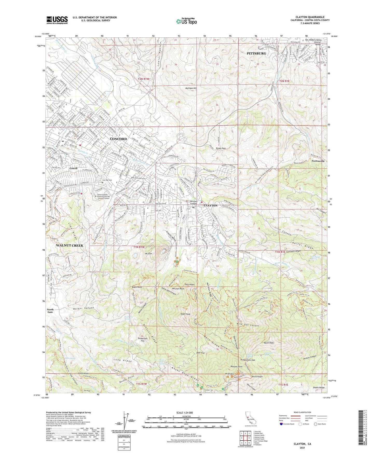
Clayton California US Topo Map
Couldn't load pickup availability
2021 topographic map quadrangle Clayton in the state of California. Scale: 1:24000. Based on the newly updated USGS 7.5' US Topo map series, this map is in the following counties: Contra Costa. The map contains contour data, water features, and other items you are used to seeing on USGS maps, but also has updated roads and other features. This is the next generation of topographic maps. Printed on high-quality waterproof paper with UV fade-resistant inks.
Quads adjacent to this one:
West: Walnut Creek
Northwest: Vine Hill
North: Honker Bay
Northeast: Antioch North
East: Antioch South
Southeast: Tassajara
South: Diablo
Southwest: Las Trampas Ridge
This map covers the same area as the classic USGS quad with code o37121h8.
Contains the following named places: Back Creek, Bald Ridge, Bel Air Shopping Center, Black Point, Brazil Quarry Park, Buckle Point, California State University East Bay - Concord Campus, Casa Correo Post Office, Castle Rock, Castle Rock Park, Chaparral Spring, City of Clayton, Clayton, Clayton Canal, Clayton City Hall, Clayton Community Ballfields, Clayton Historical Society Museum, Clayton Park, Clayton Police Department, Clayton Post Office, Clayton Quarry, Clayton Station Shopping Center, Clayton Valley Center Park, Clayton Valley Charter High School, Clayton Valley School, Clayton Valley Shopping Center, Concord Boulevard Park, Concord High School, Concord Pavilion, Concord Police Academy, Concord Police Department, Contra Costa County, Contra Costa County Fire Protection District Station 11, Contra Costa County Fire Protection District Station 22, Contra Costa County Fire Protection District Station 8, Cowell, Cowell School, Dana Plaza Shopping Center, Deer Flat, Deer Flat Creek, Devils Pulpit, Dianda Plaza Shopping Center, Donner Canyon, Donner Creek, Eagle Peak, El Dorado Middle School, Foothill Elementary School, Gehringer Park, Goethals Canyon, Highlands Elementary School, Highlands Park, Irish Canyon, Juniper Camp, Keller Canyon Landfill, Keller Ridge, KFCB-TV (Concord), KFTL-TV (Stockton), Kings Valley Christian School, Kirker Pass, Kirkwood Park, KKISFM-FM (Walnut Creek), KWUN-AM (Concord), Laurel Dell Camp, Lime Ridge, Little Pine Creek, Live Oak Cemetery, Long Ridge, Meridian Ridge, Mimulus Spring, Mitchell Canyon, Mitchell Creek Park, Mitchell Rock, Moses Rock Ridge, Moses Rock Spring, Mount Diablo, Mount Diablo Elementary School, Mount Diablo Mine, Mount Diablo School, Mount Zion, Mountain View Elementary School, Muir Camp, Mulligan Hill, Naval Weapons Station Concord, Newhall Community Park, North Gate Census Designated Place, North Peak, Nortonville, Oakhurst Country Club, Olofson Ridge, Peach Tree Springs, Peacock Creek, Pine Creek 1007 Dam, Pine Hollow Middle School, Prospectors Gap, Ransom Point, Russellmann Creek, Russellmann Park, Saint Anthony Claret Seminary, Silverwood Elementary School, Sulfur Spring, Sycamore Spring, Tabernacle School, Tenderfoot Flat, Treat Plaza Shopping Center, Twin Peaks, Uncle Sam Canyon, Vineyard Shopping Center, Walker Canyon, Westwood Elementary School, White Canyon, Wild Oat Canyon, Woodland Hills Park, ZIP Codes: 94517, 94521, 94598