
MyTopo
Duncans Mills California US Topo Map
Couldn't load pickup availability
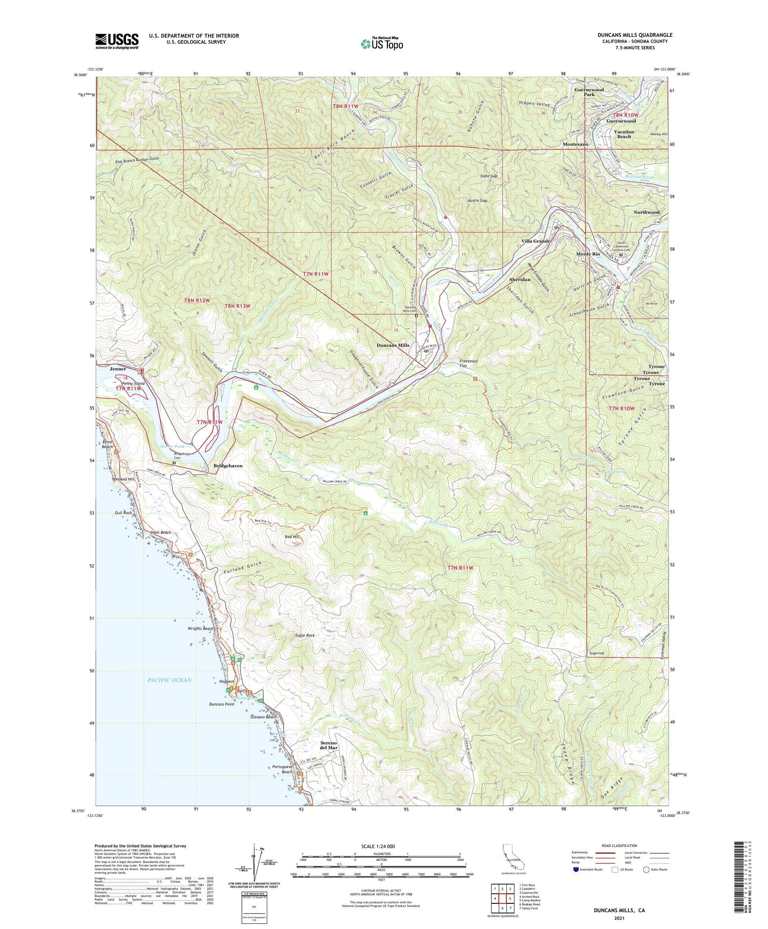
2021 topographic map quadrangle Duncans Mills in the state of California. Scale: 1:24000. Based on the newly updated USGS 7.5' US Topo map series, this map is in the following counties: Sonoma. The map contains contour data, water features, and other items you are used to seeing on USGS maps, but also has updated roads and other features. This is the next generation of topographic maps. Printed on high-quality waterproof paper with UV fade-resistant inks.
Quads adjacent to this one:
West: Arched Rock
Northwest: Fort Ross
North: Cazadero
Northeast: Guerneville
East: Camp Meeker
Southeast: Valley Ford
South: Bodega Head
This map covers the same area as the classic USGS quad with code o38123d1.
Contains the following named places: Austin Creek, Austin Gap, Big Buckhorn Ranch, Blind Beach, Bodega, Boy Scout Camp, Bridgehaven, Bridgehaven Cemetery, Browns Gulch, Bull Barn Ranch, Camp Thayer, Cazadero Volunteer Fire Department Station 2, Coleman Valley, Consolli Gulch, Crab Island, Crawford Gulch, Duncans Cove, Duncans Landing, Duncans Mills, Duncans Mills Cemetery, Duncans Mills Post Office, Duncans Point, Dutch Bill Creek, Eagle Rock, Edendale, Fern Spring, Fife Creek, Frazier Gulch, Freezeout Creek, Freezeout Flat, Furlong Gulch, Gleason Beach, Guerneville Bible Church, Guernewood, Guernewood Park, Guernewood Park Post Office, Gull Rock, Harrison Gulch, Hidden Valley, Hogback, Hulbert Creek, Jenner, Jenner Census Designated Place, Jenner Gulch, Jenner Pond, Jenner Post Office, Jenner School, Kidd Creek, Kohute Gulch, Little Buckhorn Ranch, Livereau Creek, Mesa Grande Gulch, Monte Rio, Monte Rio Branch Sonoma County Library, Monte Rio Census Designated Place, Monte Rio Fire Protection District Station 1 Headquarters, Monte Rio Fire Protection District Station 2, Monte Rio Fire Protection District Station 3, Monte Rio Fire Trail, Monte Rio School, Montesano, Mount Heller, Neeley Hill, Northwood, Oak Ridge, Ocean District School, Ocean View School, Orrs Creek, Peaked Hill, Penny Island, Petaluma Boy Scout Camp, Portuguese Beach, Red Hill, Rough Creek, Russian River Number 1 1026 Dam, Saint Catherines Catholic Cemetery, Saint Joseph Camp, Sawmill Gulch, Schoolhouse Gulch, Scotty Creek, Sereno del Mar Census Designated Place, Sheep Ridge, Sheephouse Creek, Shell Beach, Sheridan, Sheridan Gulch, Slate Gap, Slaughterhouse Gulch, Sonoma Coast State Park, Sugarloaf, Todd Boy Scout Camp, Tyrone, Tyrone Gulch, Vacation Beach, Villa Grande, Villa Grande Post Office, Willow Creek, Willow Creek Environmental Campground, Wrights Beach, ZIP Codes: 95430, 95462, 95465, 95486


