MyTopo
Cazadero California US Topo Map
Couldn't load pickup availability
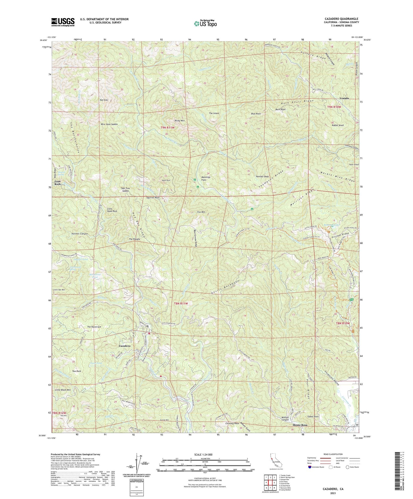
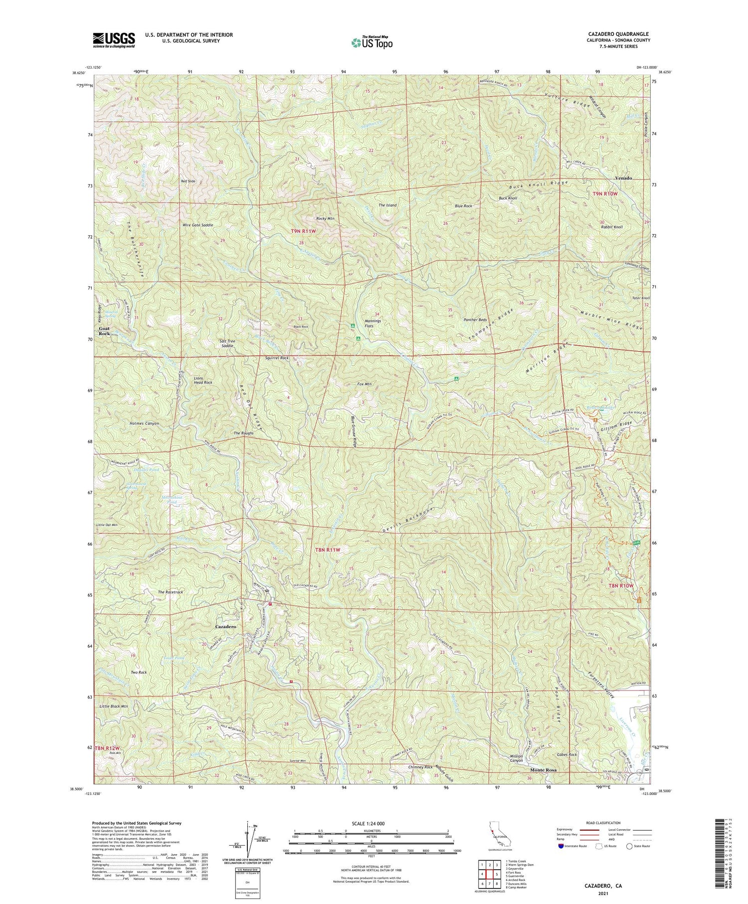
2021 topographic map quadrangle Cazadero in the state of California. Scale: 1:24000. Based on the newly updated USGS 7.5' US Topo map series, this map is in the following counties: Sonoma. The map contains contour data, water features, and other items you are used to seeing on USGS maps, but also has updated roads and other features. This is the next generation of topographic maps. Printed on high-quality waterproof paper with UV fade-resistant inks.
Quads adjacent to this one:
West: Fort Ross
Northwest: Tombs Creek
North: Warm Springs Dam
Northeast: Geyserville
East: Guerneville
Southeast: Camp Meeker
South: Duncans Mills
Southwest: Arched Rock
This map covers the same area as the classic USGS quad with code o38123e1.
Contains the following named places: Altimori Ranch, Armstrong Nature Trail, Armstrong Redwoods State Natural Reserve, Arroyo Gun Club, Austin Creek School, Austin Creek State Recreation Area, Barnes Ranch, Bearpen Creek, Berkeley Music Camp, Black Rock, Black Rock Creek, Blue Grouse Ridge, Blue Rock, Bone Creek, Brown Ranch, Buck Knoll, Buck Knoll Ridge, Bullfrog Pond Campground, Burbank Circle, Camp Royaneh, Cazadero, Cazadero Census Designated Place, Cazadero Post Office, Cazadero Volunteer Fire Department Station 1 Headquarters, Chimney Rock, Colonel Armstrong Tree, Conshea Creek, Department of Forestry and Fire Protection Cazadero Station, Devil Creek, Devils Backbone, Discovery Trail, Doelger Ranch, Dorr Place, Dugans Pond, East Austin Creek, East Austin Creek Trail, Forgotten Valley, Fox Mountain, Gabes Rock, Gilliam Creek, Gilliam Creek Trail, Gilliam Creek Trail Camp, Gilliam Ridge, Goat Rock, Government Spring, Gray Creek, Guerneville Post Office, Hale Place, Holmes Canyon, Icicle Tree, Kidd Creek School, Lawhead Canyon, Lawhead Creek, Lions Head Ranch, Lions Head Rock, Little Black Mountain, Little Oat Mountain, Luttrell Ranch, Madrone Ranch, Mannings Flat Trail Camps, Mannings Flats, Marble Mine Ridge, Mineral Spring, Mission Canyon, Mission Creek, Monte Rosa, Montgomery Elementary School, Moonshine Pond, Morrison Ridge, Ohmen Resort, Onion Pond, Panther Beds, Parker Ranch, Parmeter Ranch, Parson Jones Tree, Pioneer Trail, Pole Mountain, Pool Ridge, Pool Ridge Trail, Rabbit Knoll, Red Oat Mountain Lookout, Red Oat Ridge, Red Slide, Red Slide Creek, Redwood Forest Theater, Redwood Lake, Rocky Mountain, Romans Resort, Saint Elmo Creek, Salt Tree Saddle, Sarlandt Resort, Schoolhouse Creek, Squirrel Rock, Sulphur Creek, Sunrise Mountain, Tater Knoll, The Big Brush, The Butcherknife, The Cedars, The Island, The Racetrack, The Roughs, Thompson Creek, Thompson Ridge, Tiny Creek, Tom King Trail Camp, Toole Pond, Trospers Resort, Two Rock, Venado, Vulture Ridge, Ward Creek, West Branch Fife Creek, Williams Cattle Station, Wire Gate Saddle, ZIP Code: 95446