MyTopo
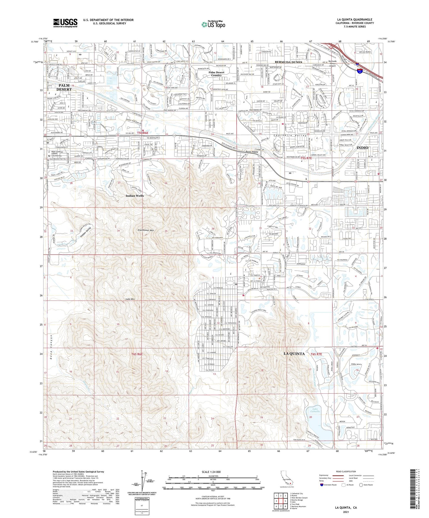
La Quinta California US Topo Map
Couldn't load pickup availability
Also explore the La Quinta Forest Service Topo of this same quad for updated USFS data
2021 topographic map quadrangle La Quinta in the state of California. Scale: 1:24000. Based on the newly updated USGS 7.5' US Topo map series, this map is in the following counties: Riverside. The map contains contour data, water features, and other items you are used to seeing on USGS maps, but also has updated roads and other features. This is the next generation of topographic maps. Printed on high-quality waterproof paper with UV fade-resistant inks.
Quads adjacent to this one:
West: Rancho Mirage
Northwest: Cathedral City
North: Myoma
Northeast: West Berdoo Canyon
East: Indio
Southeast: Valerie
South: Martinez Mountain
Southwest: Toro Peak
This map covers the same area as the classic USGS quad with code o33116f3.
Contains the following named places: Abraham Lincoln Elementary School, Arnold Palmer Golf Course, Bear Creek, Bermuda Dunes, Bermuda Dunes Airport, Bermuda Dunes Census Designated Place, Bermuda Dunes Country Club, Bermuda Palms Mobile Park, City of Indian Wells, City of La Quinta, City of Palm Desert, Cove Post Office, Coyote Creek, Dead Indian Creek, Deep Canyon, Deep Canyon Stormwater Channel, Desert Horizons Country Club, Eisenhower Mountain, El Dorado Golf Course, Fiesta Recreational Vehicle Park, First Baptist Church, Fritz Burns Park, George Washington Charter School, Gerald R Ford Elementary School, Harry S Truman Elementary School, Hidden Valley, Hope Lutheran Church, Hope Lutheran Church Columbarium, Indian Springs Golf Club, Indian Wells, Indian Wells City Hall, Indian Wells Country Club, Indian Wells Golf Course, Indian Wells Golf Resort, Indian Wells Mobile Home Park, Indian Wells Post Office, Indian Wells Recreational Vehicle Park, Indian Wells Village Shopping Center, Indio Mountain, Jack Nicklaus Private Golf Course, Jack Nicklaus Resort Golf Course, James Madison Elementary School, James Monroe Elementary School, KHCS-FM (Palm Desert), KUNA-AM (Indio), La Quinta, La Quinta Branch Riverside City and County Public Library, La Quinta Citrus Golf Course, La Quinta City Hall, La Quinta Community Park, La Quinta Dunes Golf Course, La Quinta High School, La Quinta Mountain Golf Course, La Quinta Post Office, Lake Cahuilla, Lake Cahuilla Park, Living Desert Reserve, Oasis Country Club, One Eleven La Quinta Shopping Center, Palm Desert, Palm Desert Branch Riverside City and County Public Library, Palm Desert Charter Middle School, Palm Desert Community Park, Palm Desert Country, Palm Desert Country Club, Palm Desert Country Club Branch Riverside City and County Public Library, Palm Desert High School, Palm Desert Post Office, Palm Royale Country Club, Pete Dye Resort Golf Course, Point Happy, Portola Country Club, Portola Post Office, Professional Golfers Association West Golf Course, Religious Science Church of the Desert, Riverside County Fire Department / City of La Quinta Station 70, Riverside County Fire Department Station 32 La Quinta, Riverside County Fire Department Station 55 Indian Wells, Riverside County Fire Department Station 88 - City of Indio Fire Station 3, Riverside County Fire Department Station 93 - City of La Quinta, Riverside County Sheriff's Office Substation, Sacred Heart Catholic Church, Saint George Orthodox Church, Second Missionary Baptist Church, Sheep Creek, The Pyramids Club, TPC Stadium Golf Course, West Side Detention Dike Number 2 Dam, West Side Detention Dike Number 3 Dam, West Side Detention Dike Number 4 Dam, Woodhaven Country Club, ZIP Codes: 92210, 92253