MyTopo
Manteca California US Topo Map
Couldn't load pickup availability
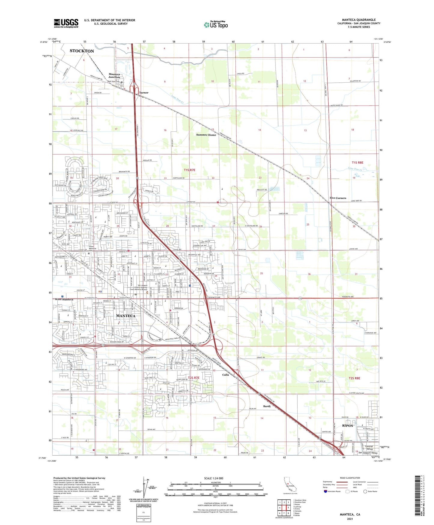
2021 topographic map quadrangle Manteca in the state of California. Scale: 1:24000. Based on the newly updated USGS 7.5' US Topo map series, this map is in the following counties: San Joaquin. The map contains contour data, water features, and other items you are used to seeing on USGS maps, but also has updated roads and other features. This is the next generation of topographic maps. Printed on high-quality waterproof paper with UV fade-resistant inks.
Quads adjacent to this one:
West: Lathrop
Northwest: Stockton West
North: Stockton East
Northeast: Peters
East: Avena
Southeast: Salida
South: Ripon
Southwest: Vernalis
This map covers the same area as the classic USGS quad with code o37121g2.
Contains the following named places: Atlanta Church, Baccileri Park, Bardi, Baymeadows Park, Brock Elliott Elementary School, Button Estates Park, Calla, Calla High School, Cardoza Shopping Center, Castle School, City of Manteca, Colony Park, Cotta Way Park, Crestwood Park, Doctors Hospital of Manteca, Doxey Park, East Union High School, Evangelical Free Church, First Assembly of God Church, First Baptist Church, First Christian Church, First Missionary Baptist Church, Five Corners, Franciscan Park, Golden West Elementary School, Golden West School, Gresytone Park, Gus Schmiedt Stadium, Hildebrand Park, Industrial Park Post Office, Joshua Cowell School, Kaiser Permanente Manteca Medical Center, Lathrop - Manteca Fire Protection District Station 32 Nile Garden, Lathrop - Manteca Fire Protection District Station 33 New Haven, Life In Christ Fellowship Church, Lincoln Elementary School, Lincoln Park, Lincoln Shopping Center, Locust Avenue Church of Christ, Lucky-Long Shopping Center, Manteca, Manteca Adult High School, Manteca Branch Stockton-San Joaquin County Public Library, Manteca Christian School, Manteca City Hall, Manteca District Ambulance Service, Manteca Division, Manteca Fire Department Station 1, Manteca Fire Department Station 242 Headquarters, Manteca Fire Department Station 243, Manteca First Church of the Nazarene, Manteca High School, Manteca Hospital, Manteca Industrial Park, Manteca Junction, Manteca Municipal Golf Course, Manteca Police Department, Manteca Post Office, Manteca Shopping Center, Martin Park, Mayors Park, Neil Hafley Elementary School, New Haven Elementary School, Nile Garden Elementary School, North Gate Park, North Side Church of Christ, Northgate Community Brethren Church, Park View Cemetery, Pentecostal Church of God, Quail Ridge Park, Raleys Union Square Shopping Center, Raymus Village Park, Ripon Poultry Farm, Saint Anthonys Catholic Church, Saint Anthonys School, Saint Francis Park, Saint Marys Episcopal Church, Saint Pauls United Methodist Church, San Joaquin County Sheriff's Office Manteca, San Joaquin Delta College Farm Laboratory, Sequoia Elementary School, Sequoia Heights Baptist Church, Sequoia Park, Shasta Elementary School, Shasta Park, Sierra High School, South Side Park, Springtime Park, Stella Brockman Elementary School, Summer Home, Summer Home School, The Church of Jesus Christ of Latter Day Saints, Turner, Union High School, Union Memorial Cemetery, Union Park, Union Road Park, United Lutheran Church, United Pentecostal Church, Veritas School, Weston School, Wilson Park, Woodward Park, Yosemite School, Yosemite Village Park, ZIP Codes: 95336, 95366