
MyTopo
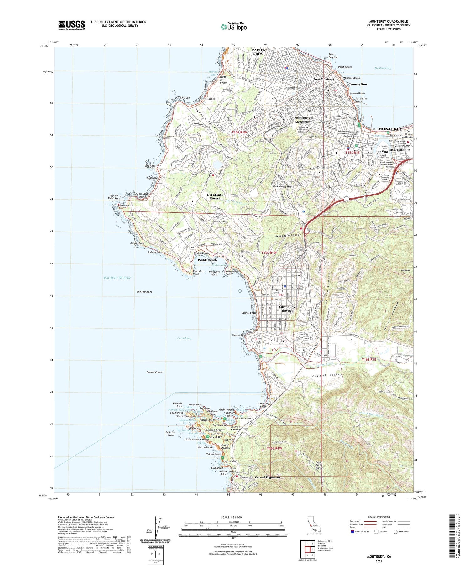
Monterey California US Topo Map
Couldn't load pickup availability
2021 topographic map quadrangle Monterey in the state of California. Scale: 1:24000. Based on the newly updated USGS 7.5' US Topo map series, this map is in the following counties: Monterey. The map contains contour data, water features, and other items you are used to seeing on USGS maps, but also has updated roads and other features. This is the next generation of topographic maps. Printed on high-quality waterproof paper with UV fade-resistant inks.
Quads adjacent to this one:
North: Monterey OE N
Northeast: Marina
East: Seaside
Southeast: Mount Carmel
South: Soberanes Point
This map covers the same area as the classic USGS quad with code o36121e8.
Contains the following named places: Aeneas Beach, Aguajito Creek, Allan Memorial Grove, American Tin Cannery Outlet Center Shopping Center, Andy Jacobsen Park, Arnett Park, Arrowhead Point, Asilomar, Asilomar Dunes Natural Preserve, Asilomar State Beach, Bay School, Bay View Elementary School, Berwick Park, Big Dome, Big Dome Cove, Big Meadow, Bird Island, Bird Island Trail, Bird Rock, Bluefish Cove, Breaker Stadium, Cabin Trail, Caledonia Park, California Division of Forestry, Canada De La Segunda, Cannery Point, Cannery Row, Cannery Row Park Plaza, Carmel Bay, Carmel Bay Ecological Reserve, Carmel Beach, Carmel Beach City Park, Carmel Canyon, Carmel Center Shopping Center, Carmel High School, Carmel Highlands, Carmel Plaza Shopping Center, Carmel Point, Carmel Rancho Shopping Center, Carmel River, Carmel River Bird Sanctuary, Carmel River Elementary School, Carmel River Lagoon and Wetland Natural Preserve, Carmel River State Beach, Carmel Valley, Carmel Woods, Carmel-by-the-Sea, Carmel-by-the-Sea Division, Carmelo Meadow, Carmelo Meadow Trail, Chase Park, China Cove, City of Carmel-by-the-Sea, City of Monterey, City of Pacific Grove, Coal Chute Point, Coast Guard Hospital, Coast Guard Pier, Community Hospital of Monterey, Community Hospital of the Monterey Peninsula, Country Club Gate Shopping Center, Custom House Plaza, Cypress Cove, Cypress Grove, Cypress Grove Trail, Cypress Point, Cypress Point Golf Course, Cypress Point Rock, Del Monte Forest, Del Monte Forest Census Designated Place, Del Monte Shopping Center, Dennis the Menace Playground, Devendorf Park, Devil Hill, Devils Cauldron, Don Dahvee Park, East Grove, El Cuartel, El Encinal Cemetery, El Estero, El Estero Park, El Potrero de San Carlos, Fan Shell Beach, Fishermans Shoreline Park, Fishermans Wharf, Forest Hill Playground, Forest Hill Shopping Center, Forest Hills Park, Forest Lake, Forest Lake 642-002 Dam, Fort Halleck, Friendly Plaza, Gibson Creek, Granite Point, Granite Point Trail, Greenwood Park, Guillemot Island, Hacienda Carmel, Hartnell Creek, Hatton Canyon, Headland Cove, Headlead Meadow, Hidden Beach, Higgins Park, Hopkins Marine Life Refuge, Huckleberry Hill, Iris Canyon, Iris Canyon Creek, Iris Canyon Greenbelt, Jacks Peak County Park, Jewel Park, Junipero Creek, KNRY-AM (Monterey), KRML-AM (Carmel), KSPB-FM (Pebble Beach), Lace Lichen Trail, Larson Field, Little Mound Meadow, Loma Alta, Lower Presidio Historic Park, Macabee Beach, Martin Canyon, Middle Cove, Midway Point, Mission Ranch, Mission Trails Park, Monastery Beach, Monterey, Monterey Bay Aquarium, Monterey Harbor, Monterey Marina, Monterey Old Town Historic District, Monterey Peninsula Dunes Golf Course, Monterey State Beach, Monterey State Historic Park, Moss Beach, Moss Cove, Moss Cove Trail, Mound Meadow, Mound Meadow Trail, Municipal Wharf Number 2, Naval Postgraduate School, New Monterey, Nine Points Park, North Fork San Jose Creek, North Moss Beach, North Point, North Shore Trail, Ohlone Coastal Cultural Preserve, Old Veteran Trail, Pacific Grove, Pacific Grove 642-003 Dam, Pacific Grove Ball Park, Pacific Grove Convalescent Hospital, Palo Corona Ranch, Pebble Beach, Pebble Beach Golf Course, Pebble Beach Riding Stables, Pelican Point, Peninsula Community Hospital, Pescadero, Pescadero Canyon, Pescadero Point, Pescadero Rocks, Piccadilly Park, Pine Ridge, Pine Ridge Trail, Piney Woods, Pinnacle Cove, Pinnacle Point, Platt Park, Point Alones, Point Cabrillo, Point Joe, Point Lobos, Point Lobos Ecological Reserve, Point Lobos State Natural Reserve, Poppy Hills Golf Course, Portola Plaza, Presidio de Monterey, Presidio of Monterey, Ptere Hay Golf Course, Punta De Pinos, Rancho Canada Golf and Country Club, Rat Hill, Reeside Access, Rip Van Winkle Open Space, S F B Morse Botanical Reserve, Saint Johns Cemetery, San Carlos Beach, San Carlos Cemetery, San Jose Creek, Sand Hill, Sand Hill Cove, Sand Hill Trail, Sandy Beach, Sawmill Gulch, Sea Lion Cove, Sea Lion Point Trail, Sea Lion Rocks, Seal Rock, Seal Rock Creek, Seals and Birds Rock Picnic Area, Seneca Creek, Serra Monument, Seventeen Mile Drive Village Shopping Center, Shoreline Park, South Plateau Trail, South Point, South Shore Trail, Spanish Bay, Spanish Bay Resort Golf Course, Spyglass Hill Golf Course, Stillwater Cove, Stillwater Cove Access, Sunset Point, The Barnyard Shopping Center, The Beach and Tennis Club, The Links at Spanish Bay, The Lone Cypress, The Pinnacles, The Pit, The Slot, Veterans Memorial Park, Via Paraiso Park, Vierras Knoll, Vizcaino-Serra Landing, Washington Park, Weston Beach, Whalers Cove, Whalers Knoll, Whalers Knoll Trail, ZIP Codes: 93921, 93950, 93953


