MyTopo
Oildale California US Topo Map
Couldn't load pickup availability
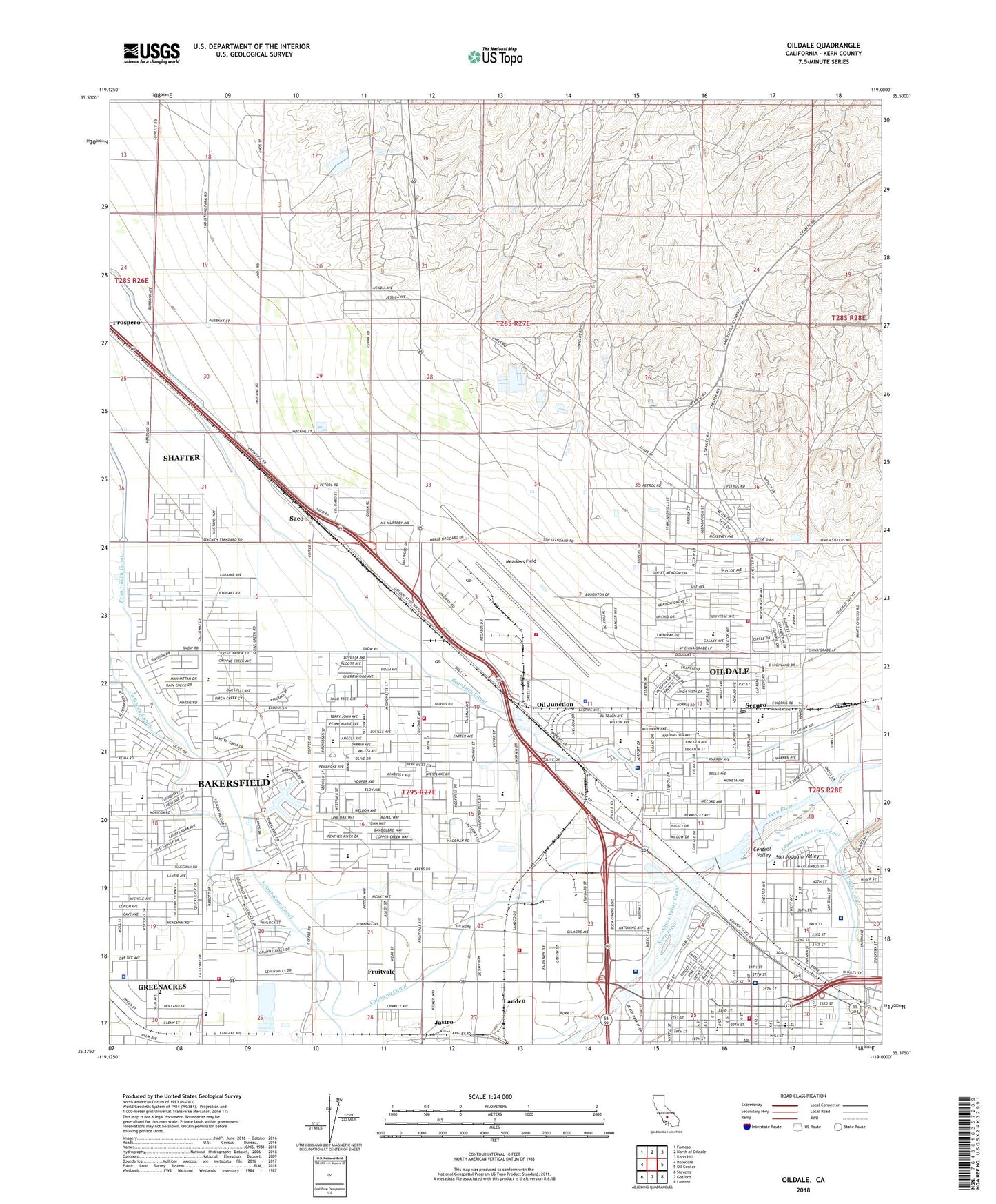
2022 topographic map quadrangle Oildale in the state of California. Scale: 1:24000. Based on the newly updated USGS 7.5' US Topo map series, this map is in the following counties: Kern. The map contains contour data, water features, and other items you are used to seeing on USGS maps, but also has updated roads and other features. This is the next generation of topographic maps. Printed on high-quality waterproof paper with UV fade-resistant inks.
Quads adjacent to this one:
West: Rosedale
Northwest: Famoso
North: North of Oildale
Northeast: Knob Hill
East: Oil Center
Southeast: Lamont
South: Gosford
Southwest: Stevens
This map covers the same area as the classic USGS quad with code o35119d1.
Contains the following named places: Apostolic Christian Academy, Apostolic Church, Bakersfield Christian Life Center, Bakersfield Christian Life School, Bakersfield Fire Department Station 1 Headquarters, Bakersfield Heart Hospital, Bakersfield Memorial Hospital, Bakersfield Post Office, Beach Park, Beardsley Canal, Beardsley Elementary School District Office, Beardsley Junior High School, Bethany Lutheran Church, Bethel Apostolic Academy, Bureau of Land Management - Bakersfield Field Office / Metro Fire Station, California Highway Patrol Central Division - Bakersfield, Calloway Drive Baptist Church, Calloway Weir, Calvary Full Gospel Church, Center Market Shopping Center, Central Park, Chester Loop Shopping Center, Christ the King Parish Hall, Christ the King School, Church of Christ, Community Church of Life, Confucius Church, Downtown Bakersfield Post Office, First Bible Baptist Church, First Christian Church, Four Weirs, Fruitdale School, Fruitvale, Fruitvale Junior High School, Fruitvale Oil Field, Garces High School, Golden State Air Ambulance, Good Samaritan Hospital, Grace Lutheran Church, Greenacres, Greenacres Census Designated Place, Greenacres School, Hall Ambulance Service, Hall Critical Care Medical Transport, Highland Congregation Church of Christ, Highland Elementary School, Highland Knolls Golf Course, Highland Park Congregation Kingdom Hall of Jehovahs Witnesses, Jastro, KAXL-FM (Green Acres), Kern Board of Trade Building, Kern County Fire Department Station 61 Norris, Kern County Fire Department Station 62 Meadows Field, Kern County Fire Department Station 63 Highland, Kern County Fire Department Station 64 - River View, Kern County Fire Department Station 65 Greenacres, Kern County Fire Department Station 66 Landco, Kern County Museum and Pioneer Village, Kern County Museum Historical Reference Library, Kern County Sheriff's Office, Kern County Sheriff's Office - Rosedale Substation, Kern Front Oil Field, KLLY-FM (Oildale), KRAB-FM (Green Acres), KWAC-AM (Bakersfield), Landco, Levee Number One Canal, Longfellow Elementary School, McCray Park, Meadows Field, Memorial Hospital Heliport, Metropolitan Recreation Center, Minner Post Office, Mounta Zion Baptist Church, Norris Elementary School, Norris Middle School, Norris Road Christian Church, North Beardsley Elementary School, North High School, North of the River Sewage Treatment Plant, North Park, Northminster Presbyterian Church, Oil Junction, Oildale, Oildale Apostolic Faith Church, Oildale Census Designated Place, Oildale Church of God, Oildale Post Office, Oildale Seventh Day Adventist Church, Oildale Shopping Center, Olive Drive Elementary School, Olive Drive Fire Training Facility, Operation Fresh Start Apostolic Faith Church, Pentecostal Holiness Church, Pentecostal Tabernacle, Phoenix Learning Center, Rathbun Branch Kern County Library, Riverview Assembly of God Church, Riverview Church of Christ, Riverview Park, Riverview Southern Baptist Church, Rosedale Bible Church, Saco, Saint Marks United Methodist Church, Sam Lynn Ball Park, San Joaquin Community Hospital, San Joaquin Community Hospital Heliport, Sears Park, Seguro, Spirit Life Centre, Standard Elementary School, Standard Middle School, Standard Park, Stella I Hills Elementary School, Stine Extension Canal, Sunshine Full Gospel Church, The Chapel of Grace Church, United Pentecostal Church, Victory Outreach Worship Center, Vista West Continuation High School, Weill Park, West Chester Baptist Church, West Coast Baptist Church, Wingland Elementary School, ZIP Codes: 93301, 93312