MyTopo
Oil Center California US Topo Map
Couldn't load pickup availability
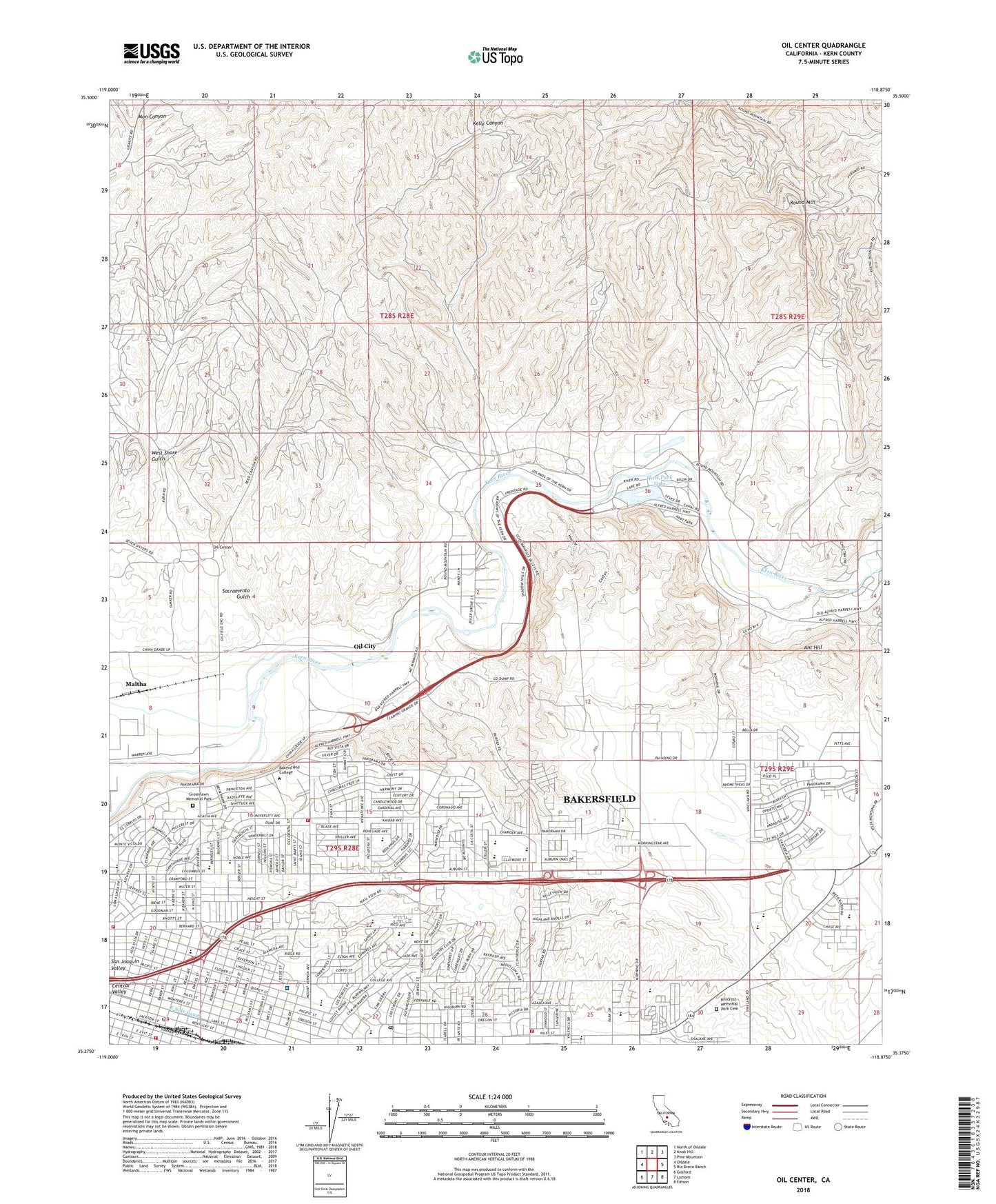
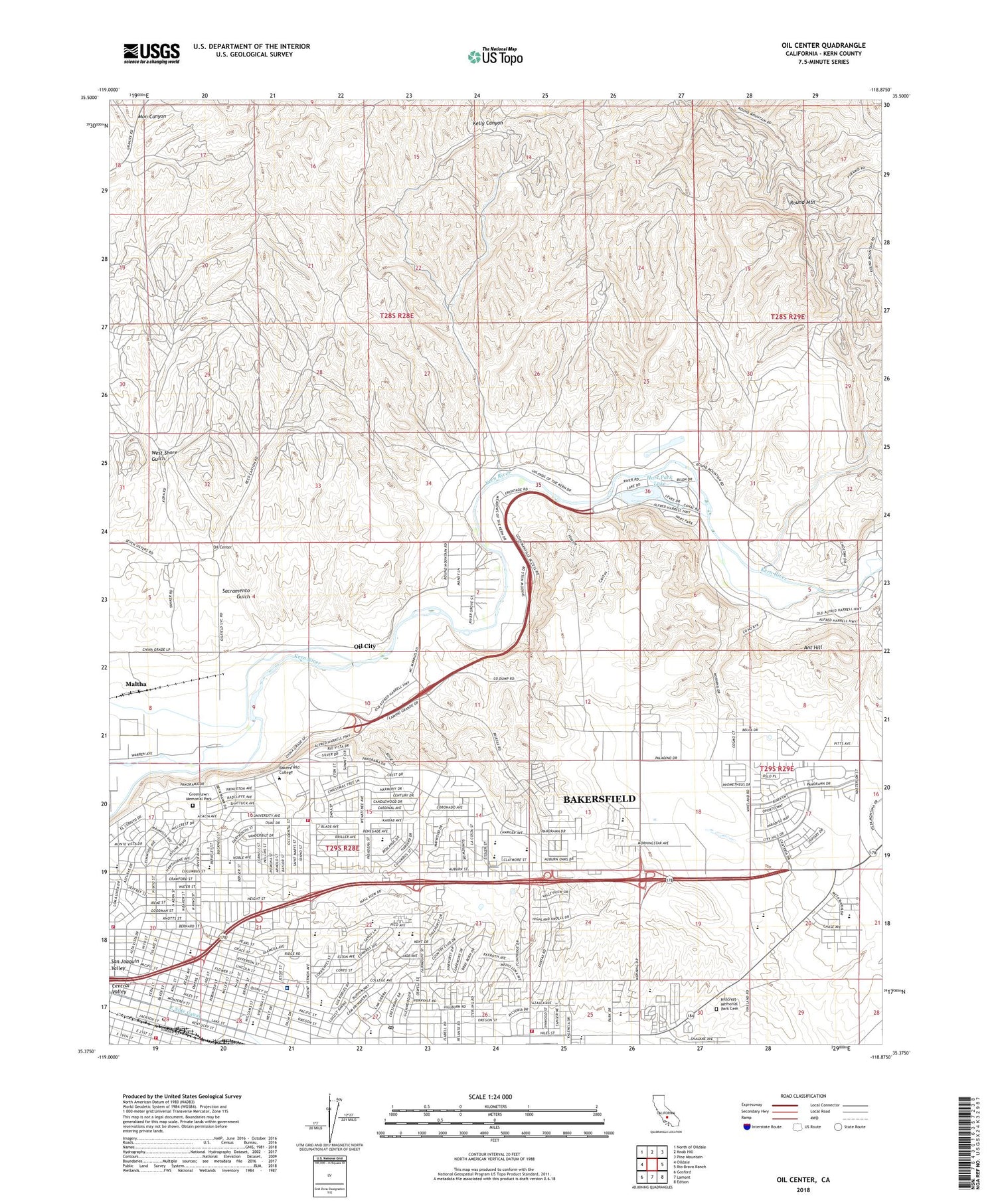
2022 topographic map quadrangle Oil Center in the state of California. Scale: 1:24000. Based on the newly updated USGS 7.5' US Topo map series, this map is in the following counties: Kern. The map contains contour data, water features, and other items you are used to seeing on USGS maps, but also has updated roads and other features. This is the next generation of topographic maps. Printed on high-quality waterproof paper with UV fade-resistant inks.
Quads adjacent to this one:
West: Oildale
Northwest: North of Oildale
North: Knob Hill
Northeast: Pine Mountain
East: Rio Bravo Ranch
Southeast: Edison
South: Lamont
Southwest: Gosford
This map covers the same area as the classic USGS quad with code o35118d8.
Contains the following named places: Ant Hill, Aztec School, Baker Street Branch Kern County Library, Bakersfield College, Bakersfield Country Club, Bakersfield Country Club Census Designated Place, Bakersfield Division, Bakersfield Fire Department Station 2, Bakersfield Fire Department Station 4, Bakersfield Fire Department Station 8, Bakersfield Junior Academy, Bakersfield Memorial Hospital, Bakersfield Rescue Mission, Beardsley Weir, California Living Museum, Calvary Baptist Church, Camp Okihi, Canyon Community Church, Carden School, Chipman Junior High School, Choctaw Valley, Choctaw Valley Census Designated Place, Church of Christ, College Heights Congregational Church, College Heights School, College Park, College Shopping Center, Colonel Howard Nichols Elementary School, Compton Junior High School, Crestmont Post Office, East Bakersfield, East Bakersfield Census Designated Place, East Bakersfield High School, East Bakersfield Post Office, East Hills Mall Shopping Center, East Hills Nazarene Church, East Hills Village Shopping Center, East Niles, El Buen Pastor Assembly of God Church, Emmanuel Lutheran Church, Faith Lighthouse, Faith Temple Pentecostal Church of God, First Hispanic Baptist Church, First Southern Baptist Church, First Southern Hispanic Baptist Church, Freedom Faith Fellowship Church, Goodmanville, Goodmanville Census Designated Place, Gordons Ferry, Grace General Baptist Church, Grace Reformed Church, Greenlawn Memorial Park, Harding Elementary School, Hart Memorial Unit, Hart Park Lake, Height Street Baptist Church, Henry Eissler Elementary School, Heritage Academy, Heritage Bible Church of Bakersfield, Heritage Park, Highland High School, Hillcrest, Hillcrest Census Designated Place, Hillcrest Memorial Park Cemetery, Hillcrest Shopping Center, Horace Mann Elementary School, Hort Elementary School, Iglesia de Dios Pentecostal, Iglesia Restaurancion Cristiana, Jefferson Elementary School, Jefferson Park, Juliet Thorner Elementary School, KAFY-AM (Bakersfield), Kern, Kern Bluff Oil Field, Kern County Fire Department Station 42 Niles, Kern Medical Center, Kern Medical Center Heliport, Kern River County Park, Kern River Oil Field, KHIS-FM (Bakersfield), Kingdom Hall of Jehovahs Witnesses, KPRX-FM (Bakersfield), KTQX-FM (Bakersfield), KXEM-AM (Bakersfield), KZPM-AM (Bakersfield), La Cresta, La Cresta Census Designated Place, La Trinidad Church, Lutheran Church of Prayer, Maltha, Memorial Stadium, Mesa Marin Raceway, Myra A Noble Elementary School, Northeast Bakersfield Branch Kern County Library, Oil Center, Oil City, Our Lady of Perpetual Help Church, Our Lady of Perpetual Help School, Panorama Park, Petroleum School, Rivergrove, Rivergrove Census Designated Place, Round Mountain, Round Mountain Oil Field, Sacramento Gulch, Sagebrush Shopping Center, Saint Clement Catholic Church, Saint Lukes Episcopal Church, Second Church of Christ Scientist, Sharktooth Oil Field, Siemon Park, Templo Calvaria, Toltec School, Treadwell, Trinity United Methodist Church, United Pentecostal Church, University Avenue Christian Church, University Baptist Church, University Park, Volcan, Washington Middle School, West Shore Gulch, Williams Elementary School, ZIP Code: 93305