MyTopo
Oroville California US Topo Map
Couldn't load pickup availability
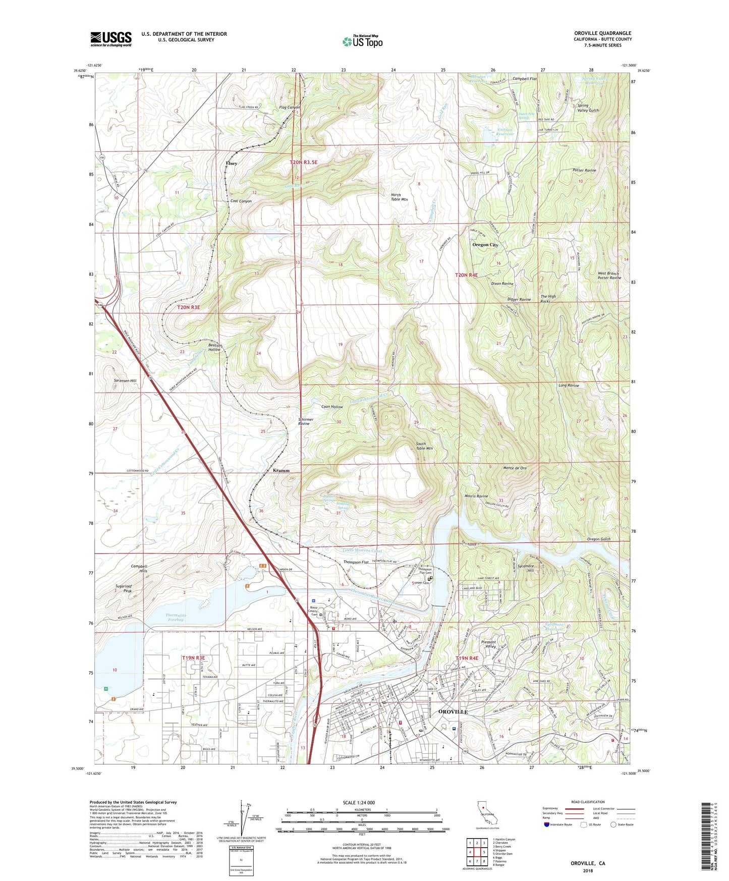
2022 topographic map quadrangle Oroville in the state of California. Scale: 1:24000. Based on the newly updated USGS 7.5' US Topo map series, this map is in the following counties: Butte. The map contains contour data, water features, and other items you are used to seeing on USGS maps, but also has updated roads and other features. This is the next generation of topographic maps. Printed on high-quality waterproof paper with UV fade-resistant inks.
Quads adjacent to this one:
West: Shippee
Northwest: Hamlin Canyon
North: Cherokee
Northeast: Berry Creek
East: Oroville Dam
Southeast: Bangor
South: Palermo
Southwest: Biggs
This map covers the same area as the classic USGS quad with code o39121e5.
Contains the following named places: A L Chaffin 346 Dam, Banner Mine, Beatson Hollow, Bedrock Park, Berry Creek Rancheria, Berry Creek Rancheria Volunteer Fire Department, Bird Street Elementary School, Bloomingdale Mine, Buffalo Mine, Bumblebee Mine, Butte County Cemetery, Butte County Center, Butte County Courthouse, Butte County Library, Butte County Sheriff's Office, California Highway Patrol Valley Division - Oroville, Campbell Flat, Campbell Hills, Cannon Ranch 345 Dam, Cannon Reservoir, Central Middle School, Church of Christ, Church of the Nazarene, Coal Canyon, Coon Hollow, Curran Hospital, Department of Forestry and Fire Protection Butte Unit / Butte County Fire Department Station 63, Digger Ravine, Dixon Ravine, Dutch Pete Spring, Eastside Elementary School, Elsey, Feather River Fish Hatchery, Feather River Hatchery 1-047 Dam, Feather River Ranger District Ambulance, First Congregational Church, First Methodist Church, First Responder Emergency Medical Services Station 22, Fish Barrier Dam, Flag Canyon, Hewitt Park, Hospital Spring, KORV-AM (Oroville), Kramm, Long Ravine, Lower Miocene Canal, Mitchell Field, Monte de Oro, Monte de Oro Mine, Morgan Reservoir, Morris Ravine, Morris Ravine School, Nelson Avenue Elementary School, Nelson Park, Ophir Post Office, Oregon City, Oregon City Cemetery, Oregon Gulch, Oro Vista Baptist Church, Oroville, Oroville Chinese Temple, Oroville City Hall, Oroville Division, Oroville Fire Department Station 1, Oroville High School, Oroville Hospital, Oroville Police Department, Oroville Post Office, Oroville Public Library, Pentecostal Assembly of God Tabernacle, Pioneer Cemetery, Pleasant Valley, Poplar Avenue Elementary School, Preston Spring, Rock River Mine, Rotary Park, Saint Pauls Episcopal Church, Saint Thomas School, Saint Thomas the Apostle Catholic Church, Sank Park, Schirmer Ravine, Seventh Day Adventist Church, Sierra Avenue Elementary School, Sorensen Hill, South Banner Mine, South Table Mountain, Spring Valley Reservoir, Standard Mine, Stanford Avenue Elementary School, Sugarloaf Peak, Sycamore Hill, Sycamore Reservoir, The Church of Jesus Christ of Latter Day Saints, The High Rocks, Thermalito, Thermalito Diversion 1-049 Dam, Thermalito Diversion Dam, Thermalito Diversion Pool, Thermalito Forebay, Thermalito Forebay North Picnic Area, Thermalito Forebay South Boat Ramp, Thermalito Power Canal, Thermalito Southern Baptist Church, Thompson Flat, Thompson Flat Cemetery, Veterans Memorial Building, West Branch Potter Ravine, Wicks Corner, Yuman, ZIP Code: 95965