MyTopo
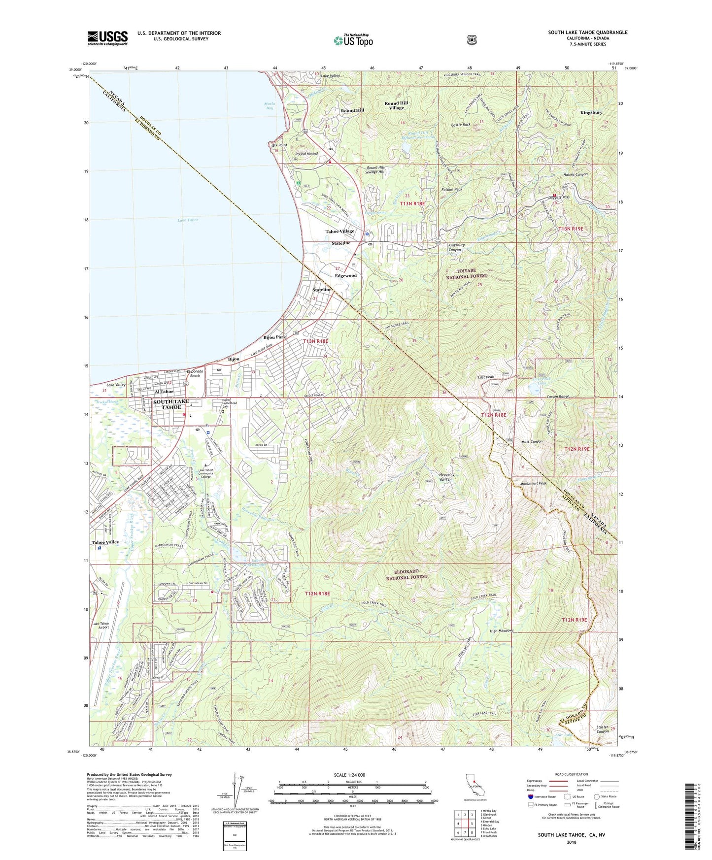
South Lake Tahoe California US Topo Map
Couldn't load pickup availability
Also explore the South Lake Tahoe Forest Service Topo of this same quad for updated USFS data
2021 topographic map quadrangle South Lake Tahoe in the states of California, Nevada. Scale: 1:24000. Based on the newly updated USGS 7.5' US Topo map series, this map is in the following counties: El Dorado, Douglas, Alpine. The map contains contour data, water features, and other items you are used to seeing on USGS maps, but also has updated roads and other features. This is the next generation of topographic maps. Printed on high-quality waterproof paper with UV fade-resistant inks.
Quads adjacent to this one:
West: Emerald Bay
Northwest: Meeks Bay
North: Glenbrook
Northeast: Genoa
East: Minden
Southeast: Woodfords
South: Freel Peak
Southwest: Echo Lake
Contains the following named places: Al Tahoe, Barton Memorial Hospital, Beachcomer Marina, Bijou, Bijou Community Park, Bijou Community School, Bijou Creek, Bijou Golf Course, Bijou Park, Bijou Post Office, Bijou Shopping Center, Burke Creek, California Shock Trauma Air Rescue 6, Castle Rock, Church of Christ of South Lake Tahoe, City of South Lake Tahoe, Cold Creek, Daggett Pass, Douglas County Sheriff's Office Substation, East Peak, East Peak Lake, Edgewood, Edgewood Creek, El Dorado Beach, El Dorado County Campground, El Dorado County Sheriff's Office, El Dorado Government Center, Elk Point, Emergency Effl Hldng 1062-002 Dam, First Baptist Church of South Lake Tahoe, Folsom Peak, Folsom Spring, Four H Club Camp, Fridays Station, Happy Homestead Cemetery, Heavenly Valley, Heavenly Valley Creek, Heavenly Valley Seventh Day Adventist Church, Heavenly Valley Ski Area, Heavenly Valley Ski Lodge, High Meadows, Hobart, Hobart Post Office, Kingdom Hall of Jehovahs Witnesses, Kingsbury, Kingsbury Canyon, Kingsbury Census Designated Place, Kingsbury Meadows, Kingsbury Middle School, Kingsbury Village, KJRC-AM (South Lake Tahoe), KOWL-AM (South Lake Tahoe), KRLT-FM (South Lake Tahoe), KTHO-AM (South Lake Tahoe), Lake Christopher, Lake Tahoe Airport, Lake Tahoe Community College, Lake Valley Fire Protection District Station 6, Lakeside Marina, Marla Bay, McFaul Creek, Meyer Visitors Center, Monument Peak, Mount Tallac High School, Nevada Beach Forest Camp, Nevada Beach Forest Service Station, Round Hill, Round Hill Effluent Dam, Round Hill Effluent Reservoir, Round Hill Sewage Hill, Round Hill Village Census Designated Place, Round Hill Village Shopping Center, Round Mound, Saint Theresa School, Saint Theresas Catholic Church, Saxon Creek, Sierra House, Sierra House Elementary School, Ski Run Marina, Smalls, South Lake Tahoe, South Lake Tahoe Branch El Dorado County Library, South Lake Tahoe Fire Department Station 1, South Lake Tahoe Fire Department Station 2, South Lake Tahoe Police Department, South Lake Tahoe Post Office, South Lake Tahoe-El Dorado Recreation Area, South Tahoe Middle School, South Tahoe School, Stateline, Stateline Census Designated Place, Stateline Medical Center, Stateline Post Office, Summit Village, Tahoe Crescent V Shopping Center, Tahoe Douglas Fire Protection District Station 1, Tahoe Douglas Fire Protection District Station 3, Tahoe Township, Tahoe Valley Campground, Tahoe Village, Thomas F Regan Memorial City Beach, Timber Cove Marina, Trout Creek, Truckee Marsh, Upper Truckee River, Zephyr Cove Post Office, ZIP Codes: 89448, 89449