MyTopo
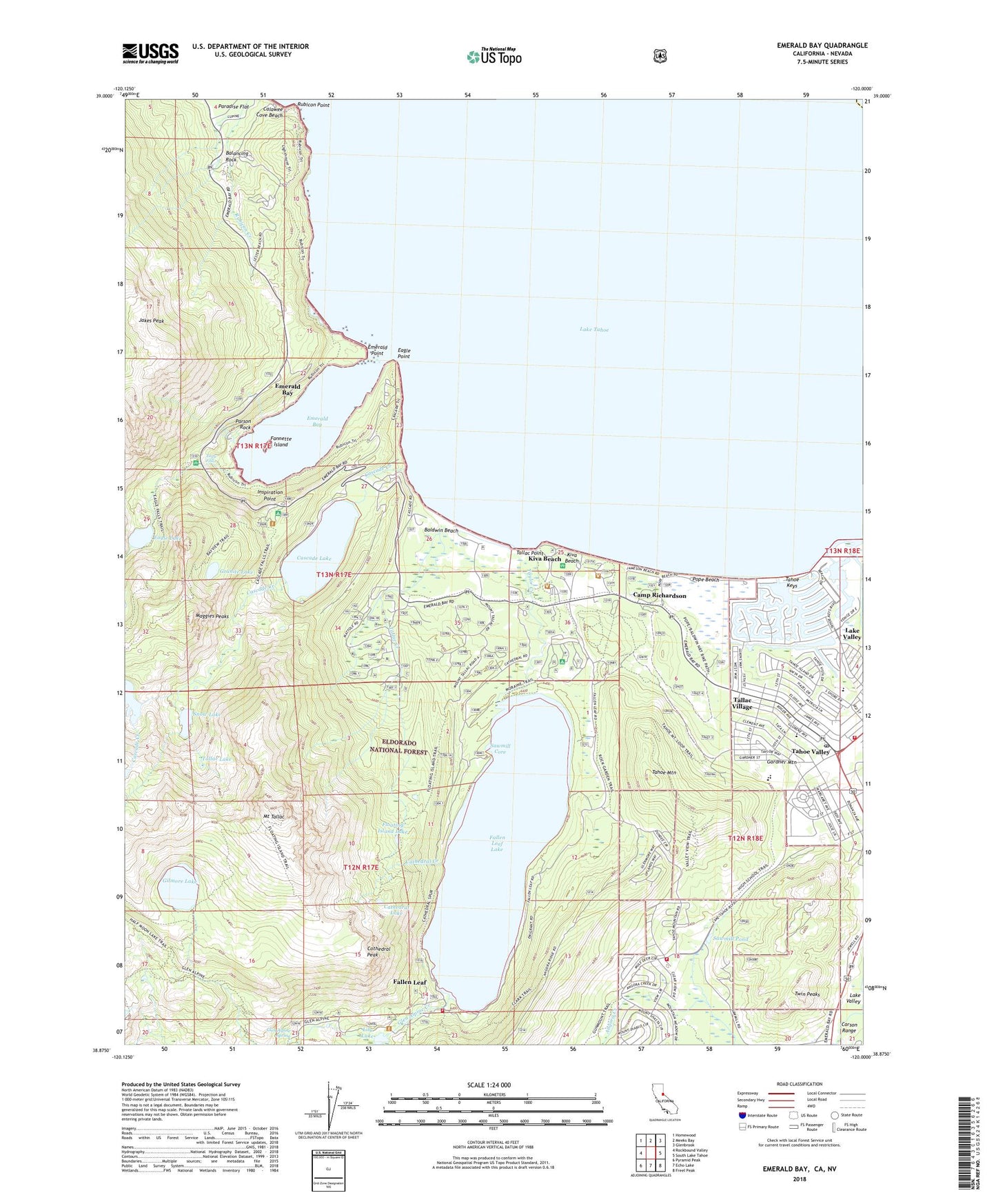
Emerald Bay California US Topo Map
Couldn't load pickup availability
Also explore the Emerald Bay Forest Service Topo of this same quad for updated USFS data
2021 topographic map quadrangle Emerald Bay in the state of California. Scale: 1:24000. Based on the newly updated USGS 7.5' US Topo map series, this map is in the following counties: El Dorado, Douglas. The map contains contour data, water features, and other items you are used to seeing on USGS maps, but also has updated roads and other features. This is the next generation of topographic maps. Printed on high-quality waterproof paper with UV fade-resistant inks.
Quads adjacent to this one:
West: Rockbound Valley
Northwest: Homewood
North: Meeks Bay
Northeast: Glenbrook
East: South Lake Tahoe
Southeast: Freel Peak
South: Echo Lake
Southwest: Pyramid Peak
Contains the following named places: Angora Lookout, Azure Lake, Balancing Rock, Balancing Rock Self-Guided Nature Trail, Baldwin Beach, Baldwin Beach Campground, Baldwin Beach Picnic Area, Bay View Guard Station, Bayview Campground, Bayview Picnic Area, Calawee Cove Beach, Camp Richardson, Camp Richardson Campground, Camp Richardson Cross Country Ski Area, Camp Shelly, Cascade Creek, Cascade Lake, Cathedral Creek, Cathedral Lake, Cathedral Peak, D.L. Bliss State Park, Eagle Falls, Eagle Falls Campground, Eagle Falls Trail, Eagle Lake, Eagle Point, Emerald Bay, Emerald Bay Overlook, Emerald Bay State Park, Emerald Point, Fallen Leaf, Fallen Leaf Campground, Fallen Leaf Dam, Fallen Leaf Lake, Fallen Leaf Lake Community Services District Fire Department, Fallen Leaf Marina, Fallen Leaf Post Office, Fallen Leaf Recreation Center, Fannette Island, Floating Island Lake, Fredericks US Forest Service Station, Gardner Mountain, Gilmore Lake, Glen Alpine Creek, Glen Alpine Spring, Granite Lake, Hope Lutheran Church of the Sierras, Inspiration Point, Jakes Peak, Kiva Beach, Kiva Beach Campground, Kiva Picnic Area, Lake Tahoe Basin Management Unit Headquarters, Lake Tahoe Basin Management Unit Ranger Station, Lake Valley, Lake Valley Fire Protection District Station 5, Lampson Plaza Shopping Center, Lighthouse Trail, Lily Lake, Lower Eagle Point Campground, Maggies Peaks, Mount Tallac, Parson Rock, Pope Beach, Pope Beach Campground, Pope Beach Picnic Area, Rubicon Point, Rubicon Trail, Sawmill Core, Sawmill Pond, Snow Lake, South Four Center Shopping Center, South Lake Tahoe Division, South Lake Tahoe Fire Department Station 3, South Shore Christian Assembly Church, South Tahoe High School, Spring Creek, Tahoe Keys, Tahoe Keys Marina, Tahoe Mountain, Tahoe Mountain Group Campground, Tahoe Valley, Tahoe Valley Elementary School, Tahoe Valley Post Office, Tallac Creek, Tallac Historical Site, Tallac Lake, Tallac Point, Tallac Village, Taylor Creek, Tea House, Twin Peaks, United States Forest Service Visitors Center, Upper Eagle Point Campground, Vikingsholm, Vikingsholm Trail, Washoe Meadows State Park