MyTopo
Westville California US Topo Map
Couldn't load pickup availability
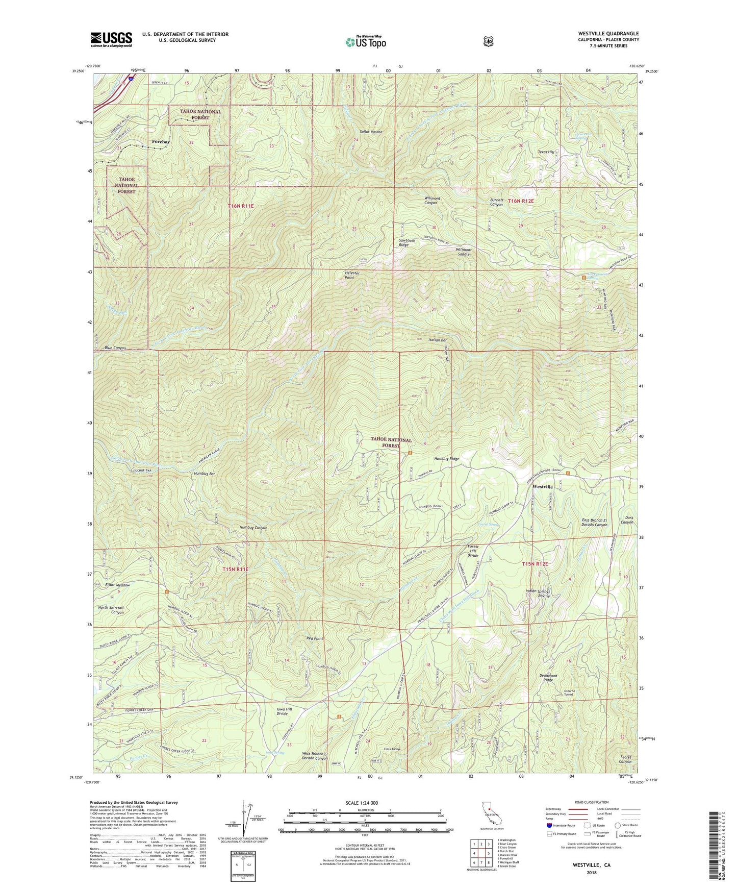
2022 topographic map quadrangle Westville in the state of California. Scale: 1:24000. Based on the newly updated USGS 7.5' US Topo map series, this map is in the following counties: Placer. The map contains contour data, water features, and other items you are used to seeing on USGS maps, but also has updated roads and other features. This is the next generation of topographic maps. Printed on high-quality waterproof paper with UV fade-resistant inks.
Quads adjacent to this one:
West: Dutch Flat
Northwest: Washington
North: Blue Canyon
Northeast: Cisco Grove
East: Duncan Peak
Southeast: Greek Store
South: Michigan Bluff
Southwest: Foresthill
This map covers the same area as the classic USGS quad with code o39120b6.
Contains the following named places: Alameda Tunnel, American Eagle Mine, American Eagle Trail, Blackhawk Mine, Blue Canyon, Burnett Canyon, Burnett Canyon Trail, Cape Horn Tunnel, China Wall Iowa Hill Ditch, Clara Tunnel, Corral Spring, Damascus, Deadwood Ridge, Dorer Mine, Dorer Ranch, Drum Forebay, Drum Forebay 97-020 Dam, East Fork North Fork North Fork American River, Elliot Meadow, Elliot Ranch, Euchre Bar Trail, Eureka Tunnel, Forebay, Forest Hill Divide, Forks House, Fulda Creek, Goat Spring, Golden River Tunnel, Government Spring, Helester Point, Herman Mine, Honey Tunnel, Humbug Bar, Humbug Canyon, Humbug Creek, Humbug Ridge, Indian Creek, Indian Springs Ravine, Iowa Hill Divide, Italian Bar, Italian Bar Trail, Jarvis Tunnel, Lost Camp Mine, Lynn Mine, Marrs Mine, Maxwell Sawmill, Monumental Creek, Mountain Gate Tunnel, Mumford Bar Trail, North Fork American Wild and Scenic River, Osborne Tunnel, Pioneer Mine, Rawhide, Rawhide Mine, Red Point, Sailor Ravine, Shady Run, Texas Hill, Texas Hill Spring, Westville, Westville Post Office, Willmont Canyon, Willmont Saddle