MyTopo
Crested Butte Colorado US Topo Map
Couldn't load pickup availability
Also explore the Crested Butte Forest Service Topo of this same quad for updated USFS data
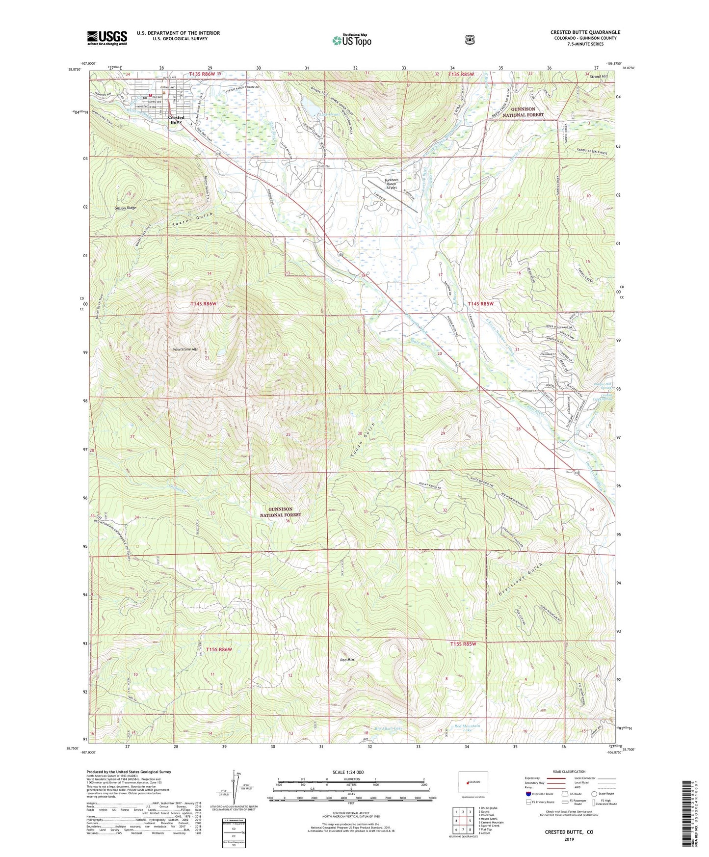
2023 topographic map quadrangle Crested Butte in the state of Colorado. Scale: 1:24000. Based on the newly updated USGS 7.5' US Topo map series, this map is in the following counties: Gunnison. The map contains contour data, water features, and other items you are used to seeing on USGS maps, but also has updated roads and other features. This is the next generation of topographic maps. Printed on high-quality waterproof paper with UV fade-resistant inks.
Quads adjacent to this one:
West: Mount Axtell
Northwest: Oh-be-joyful
North: Gothic
Northeast: Pearl Pass
East: Cement Mountain
Southeast: Almont
South: Flat Top
Southwest: Squirrel Creek
This map covers the same area as the classic USGS quad with code o38106g8.
Contains the following named places: Baxter Gulch, Big Alkali Lake, Buckhorn Ranch Airport, Buckley Mine, Bulkley Mine, Cement Creek, Cement Creek Spring, Chamber of Commerce Visitor Center, Cold Spring Ranch, Crested Butte, Crested Butte Division, Crested Butte Fire Protection District, Crested Butte High School, Crested Butte Marshal's Office, Crested Butte Mountain Heritage Museum, Crested Butte Post Office, Crested Butte Teen Center, Crested Butte Town Office, Crested Butte Town Park, Dillsworth Ditch, East River Number 2 Ditch, Farris Creek, Halazon Ditch, Imobersteg Ditch, K D Mine, KBUT-FM (Crested Butte), Lake Grant, Old Rock Community Library, Oversteeg Gulch, Queen of All Saints Catholic Church, Ranger Hot Spring, Red Mountain, Red Mountain Lake, Saint Patricks Catholic Church, Skyland Camp, Slate River, Squaw Gulch, Strand Hill, Totem Pole Park, Town of Crested Butte, Town of Crested Butte Marshalls Office-Stone Jail, Union Congregational Church, Verzuh Ditch, Verzuh Young Bafand Ditch, Whetstone Mountain