MyTopo
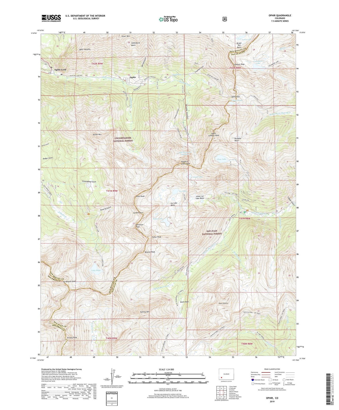
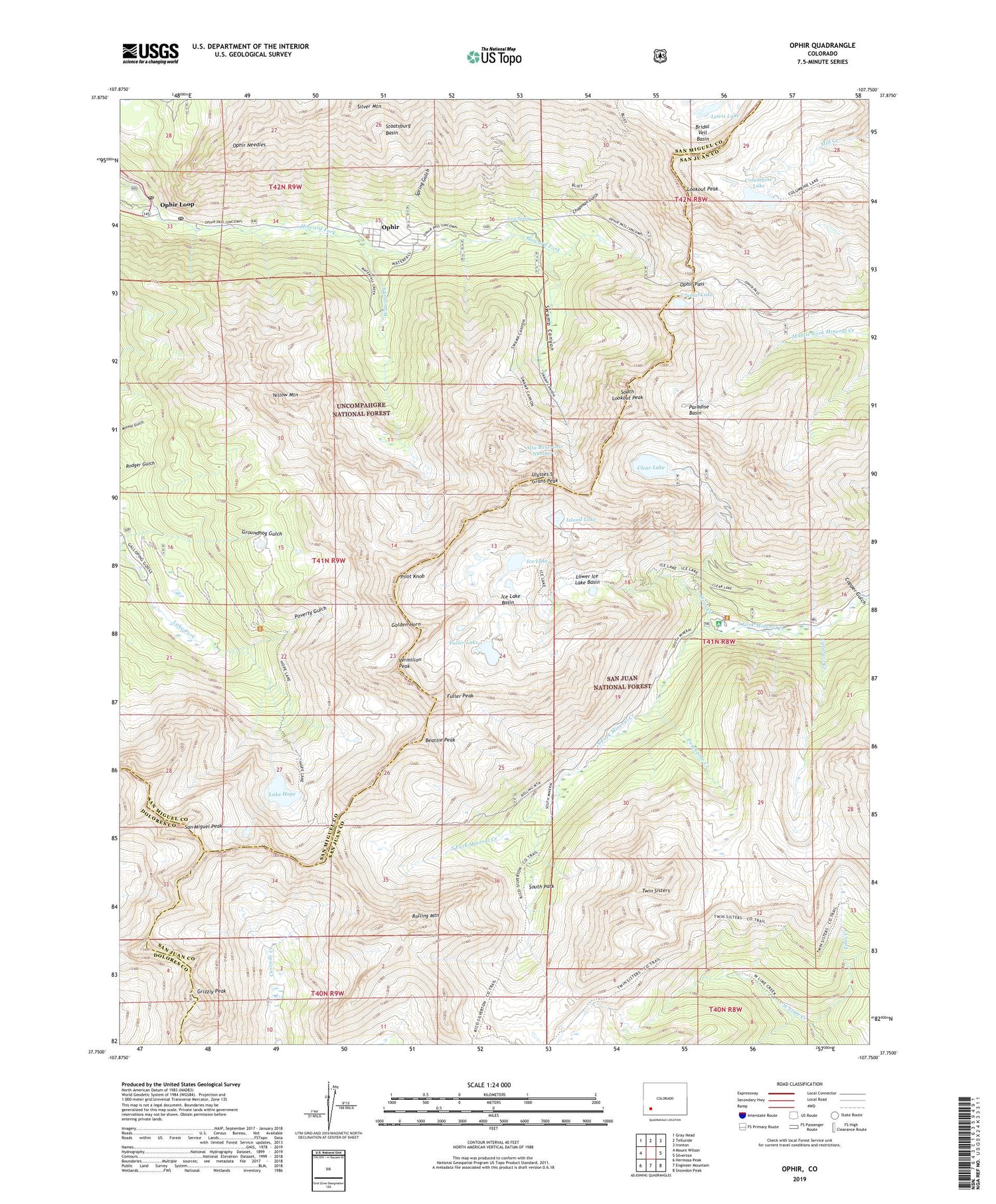
Ophir Colorado US Topo Map
Couldn't load pickup availability
Also explore the Ophir Forest Service Topo of this same quad for updated USFS data
2022 topographic map quadrangle Ophir in the state of Colorado. Scale: 1:24000. Based on the newly updated USGS 7.5' US Topo map series, this map is in the following counties: San Miguel, San Juan, Dolores. The map contains contour data, water features, and other items you are used to seeing on USGS maps, but also has updated roads and other features. This is the next generation of topographic maps. Printed on high-quality waterproof paper with UV fade-resistant inks.
Quads adjacent to this one:
West: Mount Wilson
Northwest: Gray Head
North: Telluride
Northeast: Ironton
East: Silverton
Southeast: Snowdon Peak
South: Engineer Mountain
Southwest: Hermosa Peak
This map covers the same area as the classic USGS quad with code o37107g7.
Contains the following named places: Alta Number 1 Dam, Alta Reservoir Number 1, American Frenchman Mine, Attica Mine, Badger Mine, Bandora Mine, Beattie Peak, Big Three Mine, Bridal Veil Dam, Burbank Mine, Calumet Mine, Carbonero Mine, Cataract Creek, Chapman Gulch, Clear Creek, Clear Lake, Columbine Lake, Copper Gulch, Creve Coeur Mine, Crown Point Mine, Crystal Lake, Deadwood Mine, Diamond Mine, Favorite Tunnel Mine, Fuller Lake, Fuller Peak, Gertrude Mine, Gold King Mine, Gold Run Placer, Golden Gate Mine, Golden Horn, Grandview Mine, Grizzly Peak, Groundhog Gulch, Hattie Group Mine, Highline Mine, Honduras Mine, Ice Lake, Ice Lake Basin, Ida Shaft Mine, Illinois Mine, Iron Spring, Iron Springs Group Mine, Island Lake, Kinney Tunnel Mine, Lake Hope, Lake Hope Dam, Last Home Mine, Lewis Lake, Little Eva Mine, Little Joe Crosscut Mine, Lookout Peak, Lower Ice Lake Basin, Lucy Mine, Mohawk Mine, Montana Vein Mine, Nevada Mine, New Dominion Mine, Ophir, Ophir Loop, Ophir Loop Tram, Ophir Mine, Ophir Needles, Ophir Pass, Ophir Post Office, Ophir Tunnel Mine, O'Reily Mine, Orlando Ditch, Osceola Mine, Paradise Basin, Pike County Mine, Pilot Knob, Pioneer Mine, Porcupine Creek, Poverty Gulch, Rolling Mountain, Rolling Mountain Mine, Royal Group Mine, Saint James Mine, San Juan Mine, San Miguel Peak, Santa Cruz Mine, Sarah Mine, Shamus O'Brien Mine, Shoemaker Mine, Silver Bar Mine, Silver Bell Mine, Silver Tip Mine, South Lookout Peak, South Mineral Campground, South Park, Spring Gulch, Staatsburg Basin, Suffolk Mine, Swamp Canyon, Town of Ophir, Turkey King Mine, Twin Sisters, Ulysses S Grant Peak, Upper Mill Creek Mine, Vagabond Mine, Van Mine, Vera Mine, Vermilion Peak, Waco Mine, Waterfall Creek, Webster Mine, West Lime Creek, Winnebago Mine, Woodie Mine, Yellow Mountain, Zambodga Mine