MyTopo
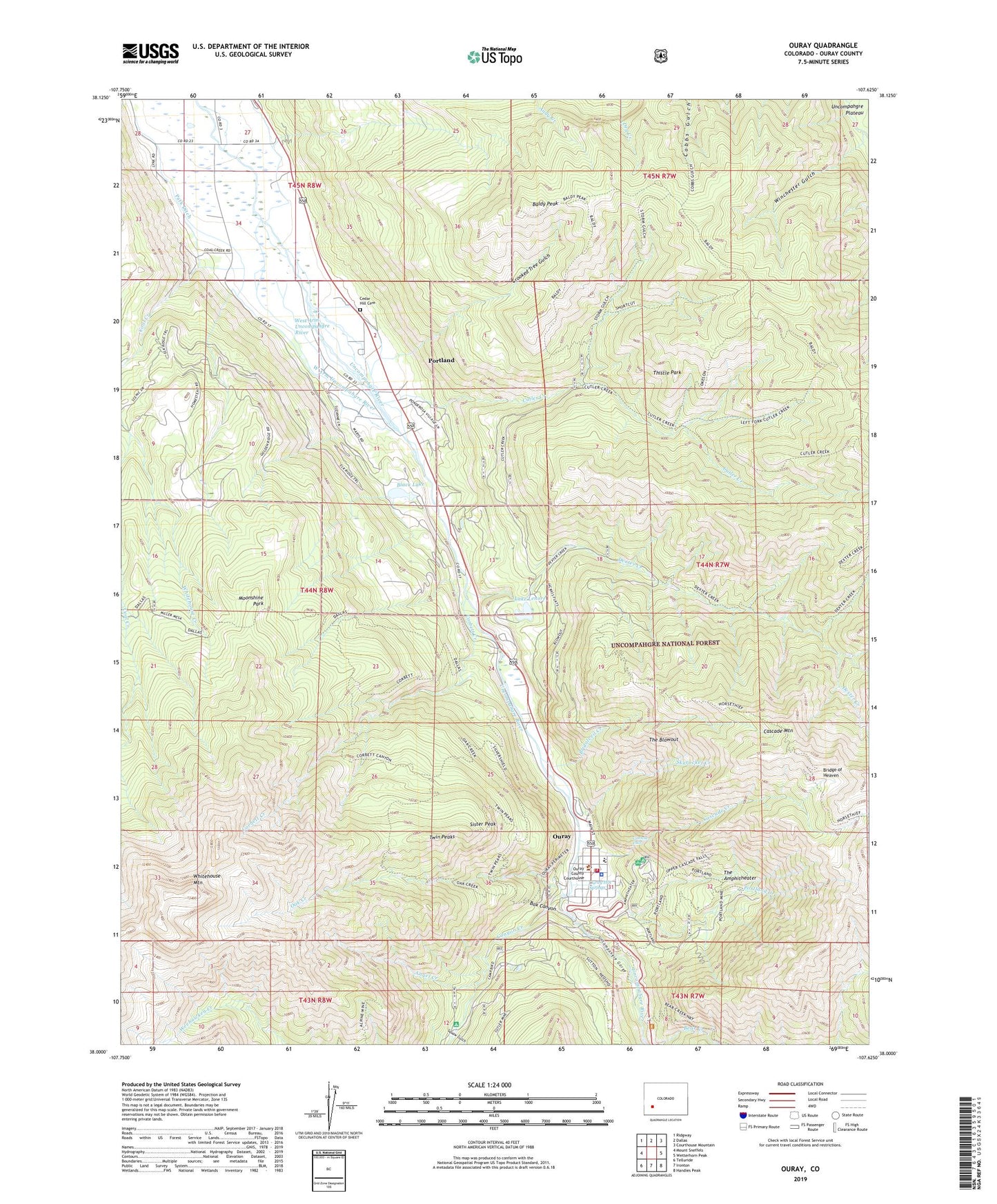
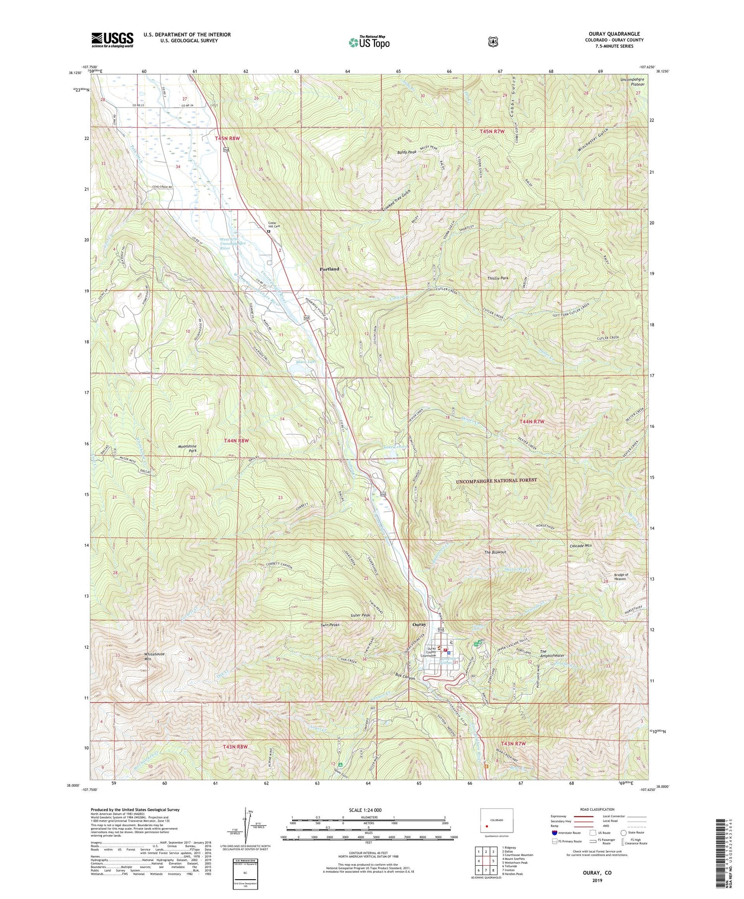
Ouray Colorado US Topo Map
Couldn't load pickup availability
Also explore the Ouray Forest Service Topo of this same quad for updated USFS data
2023 topographic map quadrangle Ouray in the state of Colorado. Scale: 1:24000. Based on the newly updated USGS 7.5' US Topo map series, this map is in the following counties: Ouray. The map contains contour data, water features, and other items you are used to seeing on USGS maps, but also has updated roads and other features. This is the next generation of topographic maps. Printed on high-quality waterproof paper with UV fade-resistant inks.
Quads adjacent to this one:
West: Mount Sneffels
Northwest: Ridgway
North: Dallas
Northeast: Courthouse Mountain
East: Wetterhorn Peak
Southeast: Handies Peak
South: Ironton
Southwest: Telluride
This map covers the same area as the classic USGS quad with code o38107a6.
Contains the following named places: Almadi Mine, Alpine Mine, Amador Mine, American Lead and Zinc Mill, American Nettie Mine, American-Nettie Mine, Amphitheater Campground, Angel Creek, Bachelor Mine, Baldy Peak, Black Lake, Boston Sunday Mine, Box Canyon, Bridalveil Creek, Bridge of Heaven, Canyon Creek, Cascade Creek, Cascade Falls, Cascade Mountain, Cedar Hill Cemetery, Chief Ouray Mine, Chipeta Mine, City of Ouray, Coal Creek, Corbett Creek, Crooked Tree Gulch, Cutler Creek, Cutler Mine, Dad Town Mine, Dalpaz Ranch, Dexter Creek, Donald Mine, El Mahdi Mine, Elkhorn Ranch, Erickson Ranch, Granger Mine, Happy Jack Mine, Horsethief Trail, Hummingbird Mine, Jonathan Mine, KURA-FM (Ouray), Lake Lenore, Little Gem Mine, Memphis Mine, Mineral Farm, Mineral Farm Mine, Moonshine Park, Nasby Mine, Neodesha Mine, News Boy Mine, Oak Creek, Old Maid Mine, Ouray, Ouray County Sheriff's Office, Ouray Hot Springs, Ouray Police Department, Ouray Post Office, Ouray Volunteer Fire Department, Park Ditch, Park Placer Mine, Ponderosa Heliport, Pony Express Mine, Portland, Portland Census Designated Place, Portland Creek, Portland Mine, Prince Lode Claims Mine, Radium Springs Swimming Pool, Rock of the Ages Mine, Rotary Park, Schofield Mine, Senorita Mine, Sequin Mine, Seven-thirty Mine, Sieberg Mine, Silvershield Mill, Sister Peak, Skyrocket Creek, Speedwell Mine, Squaw Gulch, Storm Gulch, Syracuse Mine, The Amphitheater, The Blowout, Thistle Park, Twin Peaks, Uncompahgre Gorge, Wanakah Mine, Wedge Mine, West Arm Uncompahgre River, West View Mine, Whippoorwill Mine, Whitehouse Creek, Whitehouse Mountain, Winchester Gulch