
MyTopo
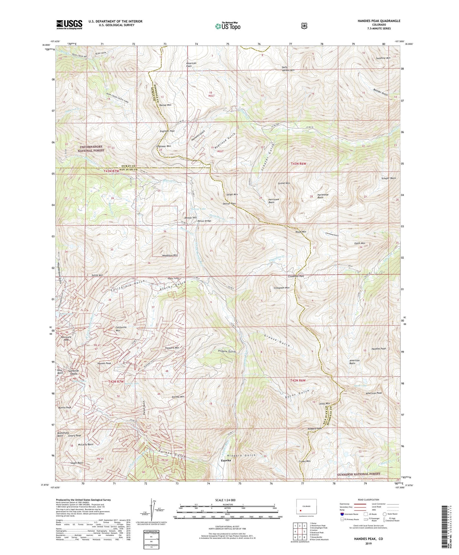
Handies Peak Colorado US Topo Map
Couldn't load pickup availability
Also explore the Handies Peak Forest Service Topo of this same quad for updated USFS data
2022 topographic map quadrangle Handies Peak in the state of Colorado. Scale: 1:24000. Based on the newly updated USGS 7.5' US Topo map series, this map is in the following counties: San Juan, Hinsdale, Ouray. The map contains contour data, water features, and other items you are used to seeing on USGS maps, but also has updated roads and other features. This is the next generation of topographic maps. Printed on high-quality waterproof paper with UV fade-resistant inks.
Quads adjacent to this one:
West: Ironton
Northwest: Ouray
North: Wetterhorn Peak
Northeast: Uncompahgre Peak
East: Redcloud Peak
Southeast: Pole Creek Mountain
South: Howardsville
Southwest: Silverton
This map covers the same area as the classic USGS quad with code o37107h5.
Contains the following named places: Adelia Mine, Alaska Number Two Mine, American Basin, American Flats, American Peak, Animas Forks, Animas Forks Mine, Annie Crook Mine, Annie Wood Mine, Auburn Group Mine, Aztec Mine, Bagley Mine, Bagley Tunnel, Barnes Tunnel Mine, Bear Creek Trail, Belcher Tunnel Number One Mine, Belle Creole Mine, Ben Butler Mine, Ben Franklin Mine, Bill Young Group Mine, Blacksmith Mine, Blanchard Placer, Bon Homme Mine, Bonanza King Mine, Bonanza Mine, Bonita Peak, Boston Mine, Brazilian Mine, British Queen Mine, Burns Gulch, Burrows Creek, Burrows Group Mine, California Gulch, California Mountain, Cinnamon Creek, Cinnamon Mountain, Cinnamon Pass, Columbus Mine, Como Consolidated Mine, Contention Mine, Crown Mountain, Custer Mine, Darley Mountain, Denver Bridge, Denver Hill, Denver Lake, Denver Pass, Detroit Hollister Mine, Dewey Mine, Dewitt Mine, Dolly Varden Mine, Dolly Varden Mountain, Early Bird Mine, Edith Mountain, Emery Peak, Endless Chain Mine, Engineer Mountain, Engineer Pass, Eureka, Eureka Gulch, Eureka Mountain, Evening Star Mine, Ezra R Mine, Forest Queen Mine, Fredericka Group Mine, Frisco Tunnel Mine, George Washington Mine, Golconda Mine, Gold Prince Mine, Golden Fleece Mine, Goodwin Mine, Gravel Mountain, Great American Mine, Grouse Gulch, Handies Peak, Hanson Peak, Hermes Group Mine, Hidden Treasure Mine, Horseshoe Basin, Horseshoe Creek, Hough Mine, Houghton Mountain, Hurricane Basin, Hurricane Peak, Illinois Boy Mine, Independence Mine, Indian Chief Mine, Jones Mountain, Klondyke Group Mine, Kohinoor Mine, Lake Como, Lake Emma, Little Ida Mine, London Mine, Lucky Jack Mine, Maid of the Mist Mine, Mammoth Mine, Mastodon Mine, McCarty Basin, Midway Mine, Mineral Point, Miners Creek, Mohawk Mine, Molly Mine, Montezuma Number One Mine, Monticello Mine, Mountain Eagle Mine, Mountain Queen Mine, Niagara Gulch, Niagara Peak, North Fork Animas River, Oro-fino Tunnels Mine, Oyama Mine, Palmetto Gulch, Palmyra Mine, Parson Gulch, Parson Lake, Picayne Gulch, Picket Mine, Placer Gulch, Plain Streak Mine, Red Cloud Mine, Redcloud Gulch, Rollo Mine, Rose Cabin, Ross Basin Mine, San Antonio Mine, San Juan Chief Mine, San Juan Queen Mine, Santiago Mine, Schafer Basin, Schafer Gulch, Scotia Mine, Seigal Mountain, Sewell Mine, Silver Chord Mine, Silver Coin Mine, Silver Queen Mine, Silver Wing Mine, Sixteen-to-one Mine, Slagle Basin, Sloan Lake, Sound Democrat Mine, South Fork Animas River, Sunnyside Mine, Sunnyside Saddle, Syracuse Pride Mine, Tempest Mine, Terry Tunnel Mine, Toltec Mine, Tom Moore Mine, Treasure Mountain, Treasure Mountain Mine, Tuttle Mountain, Uncle Sam Mine, Uncompahgre Chief Mine, Union Mine, Vermillion Tunnel Mine, Washington Mine, West Fork Animas River, White Crow Mine, Wood Mountain, Zuni Group Mine


