MyTopo
Avon Connecticut US Topo Map
Couldn't load pickup availability
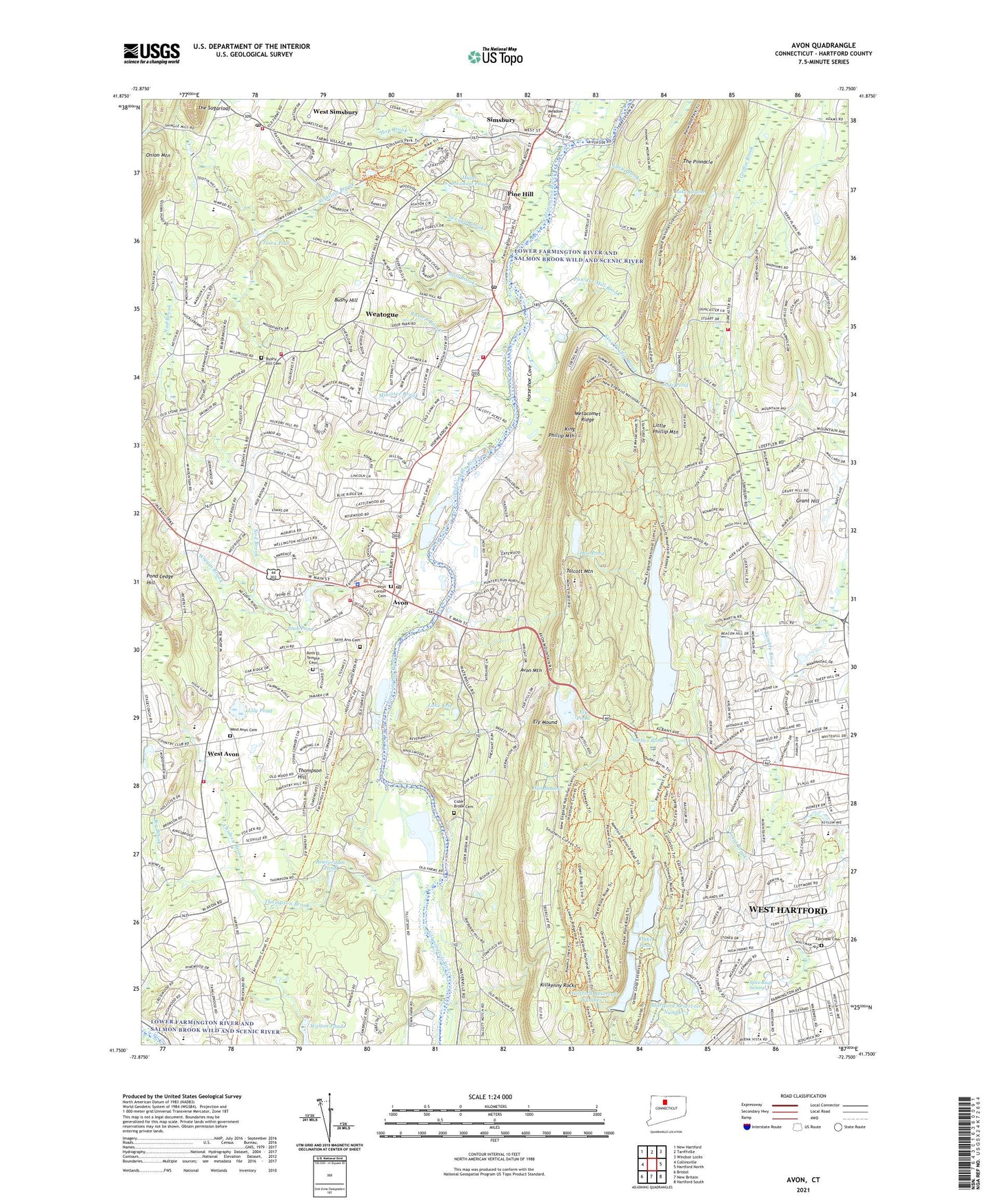
2024 topographic map quadrangle Avon in the state of Connecticut. Scale: 1:24000. Based on the newly updated USGS 7.5' US Topo map series, this map is in the following counties: Hartford. The map contains contour data, water features, and other items you are used to seeing on USGS maps, but also has updated roads and other features. This is the next generation of topographic maps. Printed on high-quality waterproof paper with UV fade-resistant inks.
Quads adjacent to this one:
West: Collinsville
Northwest: New Hartford
North: Tariffville
Northeast: Windsor Locks
East: Hartford North
Southeast: Hartford South
South: New Britain
Southwest: Bristol
This map covers the same area as the classic USGS quad with code o41072g7.
Contains the following named places: Alsop Corner, Avon, Avon Center Cemetery, Avon Congregational Church, Avon Free Public Library, Avon Historical Society Building, Avon Middle School, Avon Mountain, Avon Municipal Complex, Avon Museum, Avon Old Farms Elementary School, Avon Park North, Avon Park South, Avon Police Department, Avon Post Office, Avon Senior High School, Avon Town Hall, Avon Volunteer Fire Department Company 1, Avon Volunteer Fire Department Company 3, Barber Corner, Beaverdam Pond, Bell Compo Golf Course, Beth El Temple, Beth El Temple Jewish Cemetery, Big Brook, Bloomfield Fire Department Company 2, Braeburn School, Bugbee Reservoir, Bugbee Reservoir Dam, Bushy Hill, Bushy Hill Cemetery, Caldor Plaza Shopping Center, Case Corner, Chidsey Brook, Christ Episcopal Church of Avon, Cider Brook Cemetery, Cliffside Country Club, Cold Spring Reservoir, Cold Springs Dam, Congregation Agudas Achim, Continental Army Hospital State Monument, Crowleys Corner, Dyke Pond, Eisenhower Park, Ely Mound, Ely Pond, Ensign Bickford Dam, Ensign Bickford Pond, Ethel Walker Elementary School, Fairview Cemetery, Farmington Fire Marshal's Office, Farmington High School, Farmington Valley Art Center, Farmington Valley Mall Shopping Center, Fernridge Park, Fisher Meadows Recreation Area, Flagg Road United Church, Floyd Bugbee School, Foote Corners, Gale Pond, Gale Pond Dam, Golf Club of Avon, Grant Hill, Grimes Brook, Hart Meadow, Hartford Reservoir 6 East Dam, Hartford Reservoir 6 South Dam, Hartford Reservoir 6 Southeast Dam, Hartford Reservoir Number 1 Dam, Hartford Reservoir Number 2, Hartford Reservoir Number 2 Dam, Hartford Reservoir Number 3, Hartford Reservoir Number 3 Dam, Hartford Reservoir Number 5, Hartford Reservoir Number 5 Dam, Hartford Reservoir Number 6, Hazel Meadow Pond, Hoe Pond, Hop Brook, Horseshoe Cove, Killkenny Rocks, King Phillip Brook, King Phillip Mountain, Lake Erie, Lake Louise, LaSallette Novitiate, Latimer Lane Elementary School, Lily Pond, Little Phillip Mountain, Lucy Brook, MacDonald Memorial Park, Massacoe State Forest, Metacomet Trail, Minister Brook, Mooneys Woods, Newton Brainard Forest, Nod Brook, Nod Brook Mall Shopping Center, Nod Brook State Wildlife Area, Norfeldt Elementary School, Northwest Catholic High School, Old Avon Village, Penwood State Park, Pine Grove Elementary School, Pine Grove Historic District, Pine Grove School Historic District, Pine Hill, Plaza 44 Shopping Center, Pond Ledge Hill, Powder Forest Business Park, Powder Mill Brook, Recreation Association Winding Trails Camp, Renbrook School, Richard W Dunne Library, Rochambeau Campsite, Russell Brook, Saint Ann's Cemetery, Saint Anns Church, Scoville Park and Ballfield, Second Brook, Sedgwick Middle School, Shuvah Yisrael Messianic, Simsbury High School, Simsbury Public Library, Simsbury State Wildlife Area, Simsbury United Methodist Church, Simsbury Volunteer Ambulance Association, Simsbury Volunteer Fire Company Bushy Hill Station, Simsbury Volunteer Fire Company Weatogue Station, Simsbury Volunteer Fire Company West Simsbury Station, Solomon Schecter School, South School, Sperry Park, Spice Bush Swamp, Still Brook, Stratton Brook, Stratton Brook State Park, Stub Pond, Stub Pond Dam, Sunset Plaza Shopping Center, Sycamore Hills Recreation Area, Talcott Dam, Talcott Mountain, Talcott Mountain Academy of Science and Mathematics, Talcott Mountain State Park, Talcott Reservoir, Talcott Reservoir Diversion Dike, Talcott Reservoir Main Dam, The Church of Jesus Christ of Latter Day Saints, The Cobb School, The Pinnacle, The Sugarloaf, Thompson Brook, Thompson Hill, Tootin' Hills, Tootin Hills Elementary School, Tower Business Park, Town of Avon, Town of Simsbury, Town of West Hartford, Town Pool, Towpath Elementary School, Tri-Town Shopping Plaza Shopping Center, Trout Brook, Tumble Brook Country Club, Valley Community Baptist Church, Veterans Memorial Rink, Walton Pond, Wampanoag Country Club, WCCC-AM (West Hartford), WCCC-FM (Hartford), Weatogue, Weatogue Census Designated Place, Weatogue Park, Weatogue Post Office, WEDH-TV (Hartford), Welles Pond, West Avon, West Avon Cemetery, West Avon Congregational Church, West Hartford Census Designated Place, West Simsbury, West Simsbury Post Office, Westmoor Park, WFSB-TV (Hartford), WHCT-TV (Hartford), Whitings Corner, Wiggin Brook, William H Hall High School, WTIC-AM (Hartford), WTIC-FM (Hartford), WWUH-FM (West Hartford), ZIP Codes: 06001, 06089, 06092, 06107, 06117