MyTopo
Essex Connecticut US Topo Map
Couldn't load pickup availability
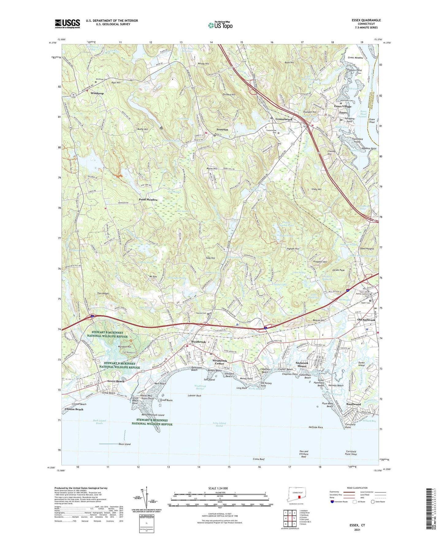
2024 topographic map quadrangle Essex in the state of Connecticut. Scale: 1:24000. Based on the newly updated USGS 7.5' US Topo map series, this map is in the following counties: Middlesex, New London. The map contains contour data, water features, and other items you are used to seeing on USGS maps, but also has updated roads and other features. This is the next generation of topographic maps. Printed on high-quality waterproof paper with UV fade-resistant inks.
Quads adjacent to this one:
West: Clinton
Northwest: Haddam
North: Deep River
Northeast: Hamburg
East: Old Lyme
Southeast: Orient
Southwest: Clinton OE S
This map covers the same area as the classic USGS quad with code o41072c4.
Contains the following named places: Acton Public Library, All Saints Episcopal Church, Ames Shopping Center, Back River, Beacon Hill, Birch Millpond, Birch Millpond Dam, Book Hill, Brockway Island, Bushy Hill, Bushy Hill Pond, Camp Pequot, Cedar Swamp, Centerbrook, Centerbrook Cemetery, Centerbrook Congregational Church, Centerbrook Post Office, Chalker Beach, Chalkers Millpond, Chapman, Chapman Beach, Chapman Point, Chapman Strand, Chapmans Pond, Cheney Hill, Clark Memorial Field, Clinton Beach, Cold Spring, Cold Spring Brook, Comstock Pond, Comstock Pond Dam, Connecticut Auto Mall, Connecticut River Museum, Connecticut State Police Troop F - Westbrook, Cornfield Park, Cornfield Point, Cornfield Point Shoal, Cranberry Pond, Crane Reef, Crystal Lake, Crystal Lake Town Park, Custom Industrial Park, Cypress Cemetery, Daisy Ingraham School, Dee Pond, Deep River Fire Department Winthrop Street Station, Duck Island, Duck Island Breakwaters, Duck Island Roads, Dunks Island, Eightmile River, Elm Street Industrial Park, Elm Street Shopping Center, Ely Landing, Emmanuel Baptist Church, Essex, Essex Ambulance Association, Essex Elementary School, Essex Fire Engine Company 1 Headquarters, Essex Fire Engine Company 2, Essex Island Marina, Essex Library Association, Essex Plaza Shopping Center, Essex Post Office, Essex Reef Light, Essex Saybrook Antique Village Shopping Center, Essex Shoal, Essex Shoal Channel, Essex Square, Essex Town Dock, Essex Town Hall, Essex Town Park, Essex Village Census Designated Place, Falls River, Falls River Pond, First Baptist Church, Fishing Brook, Foxboro Point, Gatchen Creek, Great Hammock Beach, Great Meadow, Great Rocks, Grove Beach, Grove Beach Point, Hagar Creek, Halftide Rock, Hammock Dock, Harveys Beach, Hawks Nest, Haydens Point, Hen and Chickens Reef, Hills Academy, Hollycroft Foundation, Incarnation Camp, Indiantown Beach, Indiantown Harbor, Ingham Hill, Ingham Ponds, Interstate 95 Tourist Information Center, Ivoryton, Ivoryton Library Association, Ivoryton Playhouse, Ivoryton Post Office, Jacobs Peak, John Winthrop Junior High School, Johnson Pond, Johnson Pond Dam, Kathleen E Goodwin Elementary School, Kelsey Hill, Knollwood, Lake Rockview, Lobster Rock, Long Rock, Lord Pond, Main Street School, Mares Hill, McVeagh Pond, Menunketesuck Island, Menunketesuck River, Messerschmidt Pond, Messerschmidt Pond Dam, Middle Beach, Middle Cove, Mill Meadows, Mill Pond, Mill Pond Dam, Mine Swamp, Money Point, Mount Tom, Mud Creek, Mud River, Murdock Hill, Museum of Fife and Drum, North Cove, Obed Heights, Old Kelsey Point, Old Saybrook, Old Saybrook Chamber of Commerce, Old Saybrook Fire Department Company 1, Old Saybrook Fire Marshal's Office, Old Saybrook Historical Society Building, Old Saybrook Police Department, Old Saybrook Police Heliport, Old Saybrook Post Office, Old Saybrook Senior High School, Old Saybrook Shopping Center, Old Saybrook South Green, Old Saybrook Town Green, Old Saybrook Town Hall, Orchard Hill, Ortners Pond, Oxford Academy, Oyster River, Patchogue River, Pequot Swamp, Pequot Swamp Pond, Pilots Point, Pine Orchard, Plane Brook, Plattwood Park, Plum Bank Beach, Plum Bank Creek, Pond Meadow, Post Hill, Potopaug Point, Pratt House, Prospect Hill, Quotonset Beach, Rintoul Pond, Riverview Cemetery, Saint Johns Roman Catholic Cemetery, Salt Island, Salt Meadow National Wildlife Refuge, Salt Works Bay, Saybrook Manor, Saybrook Manor Census Designated Place, Saybrook Station, Shoreline Clinic Heliport, Sokol Hall, South Cove, Spring Lot Brook, Stannard Beach, Stumpet Hill, Sunset Pond, Thatchbed Island, The Ledges, The Oyster River Shopping Center, Tiffany Brook, Toby Hill, Town Line Center Shopping Center, Town of Deep River, Town of Essex, Town of Old Saybrook, Town of Westbrook, Towne Center Plaza Shopping Center, Trask Town Park, Trout Brook, Upper Cemetery, Valley Regional High School, Vincent Pond, Viney Hill, Viney Hill Brook, Ward Brook, West Beach, Westbrook, Westbrook Center Census Designated Place, Westbrook Emergency Medical Services, Westbrook Fire Department Headquarters, Westbrook Fire Department Station 2, Westbrook Fire Marshal's Office, Westbrook Harbor, Westbrook High School, Westbrook Historical Society Building, Westbrook Industrial Park, Westbrook Information Center, Westbrook Middle School, Westbrook Police Department, Westbrook Post Office, Westbrook Public Library, Westbrook Town Hall, Willard Bay, Winthrop, Winthrop Cemetery, Winthrop Country Club, WLIS-AM (Old Saybrook), Worthington Pond, Wrights Pond, Wrights Pond Dam, Youth and Family Services Office, ZIP Codes: 06409, 06417, 06426, 06442, 06475, 06498