MyTopo
Clinton Connecticut US Topo Map
Couldn't load pickup availability
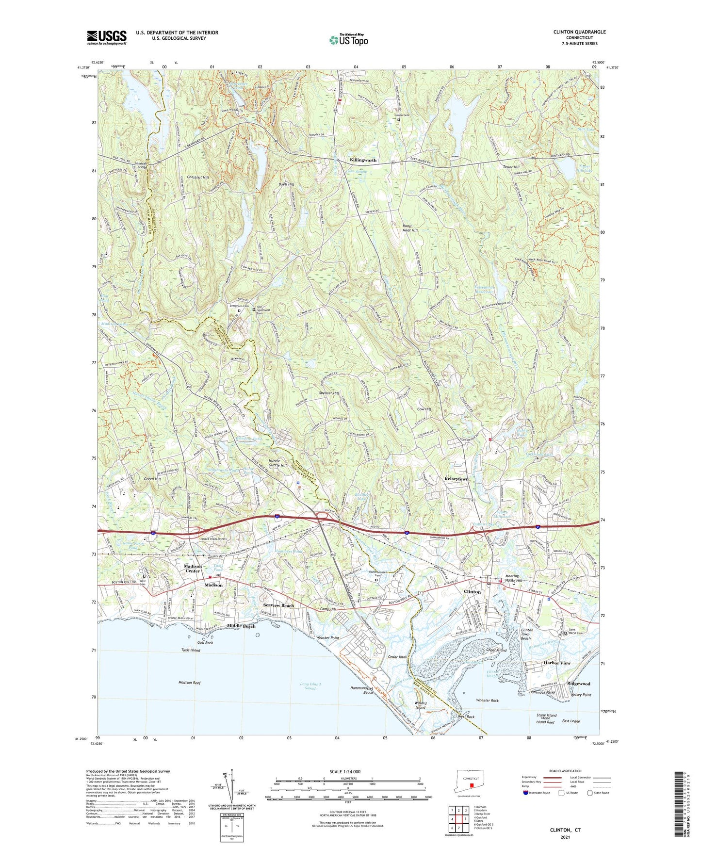
2024 topographic map quadrangle Clinton in the state of Connecticut. Scale: 1:24000. Based on the newly updated USGS 7.5' US Topo map series, this map is in the following counties: Middlesex, New Haven. The map contains contour data, water features, and other items you are used to seeing on USGS maps, but also has updated roads and other features. This is the next generation of topographic maps. Printed on high-quality waterproof paper with UV fade-resistant inks.
Quads adjacent to this one:
West: Guilford
Northwest: Durham
North: Haddam
Northeast: Deep River
East: Essex
South: Clinton OE S
Southwest: Guilford OE S
This map covers the same area as the classic USGS quad with code o41072c5.
Contains the following named places: Abraham Pierson School, Academy School, Allis-Bushnell House and Museum, Boulder Lake, Boulder Lake Dam, Buell Hill, Bushy Pond, Camp Hadar, Camp Hill, Camp Laurelwood, Captain Elisha White House Museum, Cedar Island, Cedar Knoll, Cedar Swamp, Chamaud Vineyards, Chatfield Hollow Brook, Chatfield Hollow State Park, Chestnut Hill, Church of the Open Door, Clinton, Clinton Beach, Clinton Breakwater, Clinton Census Designated Place, Clinton Chamber of Commerce, Clinton Commons Shopping Center, Clinton Crossing Factory Outlets Shopping Center, Clinton Harbor, Clinton Historical Society Building, Clinton Manor Shopping Center, Clinton Plaza Shopping Center, Clinton Police Department, Clinton Post Office, Clinton Shopping Parkade Shopping Center, Clinton Town Beach, Clinton Town Garage, Clinton Town Hall, Clinton United Methodist Church, Clinton Volunteer Fire Department Station 1 Headquarters, Clinton Volunteer Fire Department Station 2, Cow Hill, Cow Hill Red School, Dardanells, Deacon John Grave House Museum, Deer Lake, Deer Lake Camp, Deer Lake Dam, Duck Island Roads, Dudley Creek, E C Scranton Memorial Library, East Ledge, East Wharf, Episcopal Church of the Holy Advent, Evergreen Cemetery, Fence Creek, First Church of Christ Congregation, First Congregational Church, Flanders, Fort Constitution, Foster Pond, Fosters Pond Dam, Game Farm Pond, Green Hill, Griswold Airport, Grove School, Gull Rock, Hammock Point, Hammock River, Hammonasset Beach, Hammonasset Cemetery, Hammonasset Natural Area Preserve, Hammonasset Reservoir Dam, Hammonasset River, Hammonasset River Town Dock, Hammonasset State Park, Hand High School, Harbor View, Heft Brook, Henry Carter Hull Library, Hog Pond Brook, Horse Pond, Hummers Pond, Huzzle Guzzle Brook, Huzzle Guzzle Hill, Indian Lake, Indian Lake Dam, Indian River, Island Avenue School, J Milton Jeffrey School, Jared Eliot Middle School, Kelsey Point, Kelseytown, Kelseytown Reservoir, Kelseytown Reservoir Dam, Killingworth, Killingworth Ambulance Association, Killingworth Congregational Church, Killingworth Reservoir, Killingworth Reservoir Dam, Killingworth Volunteer Fire Company Station 1 Headquarters, Lafayette Green, Lake Hammonasset, Lake View, Lewin G Joel Junior School, Liberty Green Plaza Shopping Center, Lockwood Lake, Lockwood Lake Dam, Lord Corner, Lutheran Church of Madison, Madison, Madison Ambulance Association, Madison Center Census Designated Place, Madison Country Club, Madison Fire Marshal's Office, Madison Green, Madison Green Historic District, Madison Historical Society Building, Madison Hose Company 1, Madison Lakes, Madison Military Academy, Madison Police Department, Madison Post Office, Madison Reef, Madison Shopping Plaza Shopping Center, Meeting House Hill, Meigs Point Nature Center, Middle Beach, Mill District School House, Morgan High School, Neck River, Ninevah, Ninevah Bridge, Nutmeg Center Shopping Center, Oil Mill Brook, Old Southwest Cemetery, Ridgewood, Roast Meat Hill, Saint Margaret Roman Catholic Church, Saint Marys Cemetery, Saint Marys Church of the Visitation, Sandy Point, Schreeder Pond, Schreeder Pond Dam, Schumanns Pond, Seaview Beach, Spencer Hill, Spruce Corner, Stanton House Museum, Star Lake, Stone Island, Stone Island Reef, Temple Beth Tikvah, The Morgan High School, Toms Creek, Tower Hill, Tower Hill Lake, Tower Hill Lake Dam, Town of Clinton, Tuxis Island, Tuxis Pond, Union Cemetery, Upper Millpond, Upper Millpond Dam, Waterside, Waterside Green Park, Webster Point, West Cemetery, West Rock, West Wharf, Whedons Pond, Wheeler Rock, Willard Island, Woods, ZIP Codes: 06413, 06419, 06443