MyTopo
Haddam Connecticut US Topo Map
Couldn't load pickup availability
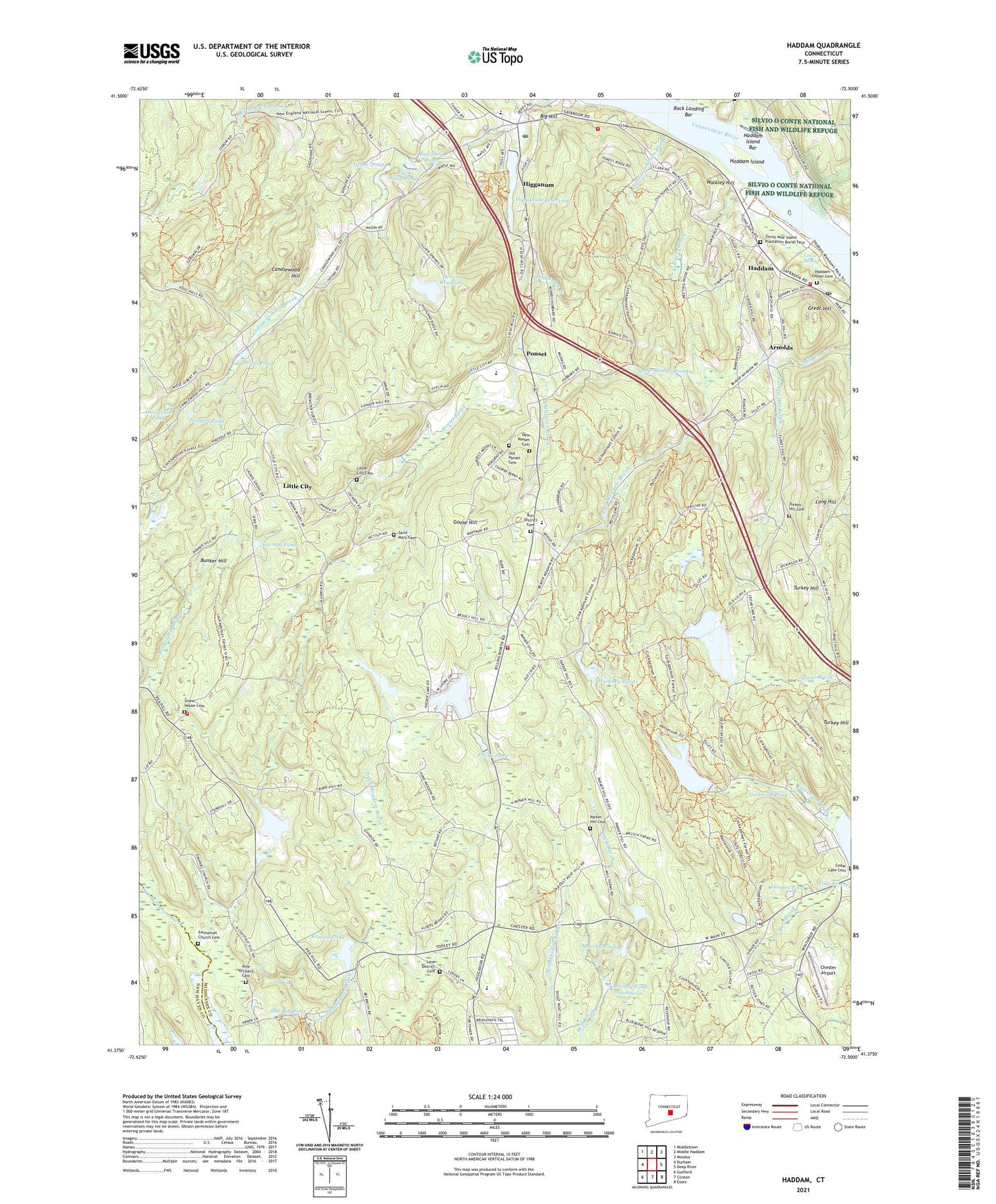
2024 topographic map quadrangle Haddam in the state of Connecticut. Scale: 1:24000. Based on the newly updated USGS 7.5' US Topo map series, this map is in the following counties: Middlesex, New Haven. The map contains contour data, water features, and other items you are used to seeing on USGS maps, but also has updated roads and other features. This is the next generation of topographic maps. Printed on high-quality waterproof paper with UV fade-resistant inks.
Quads adjacent to this one:
West: Durham
Northwest: Middletown
North: Middle Haddam
Northeast: Moodus
East: Deep River
Southeast: Essex
South: Clinton
Southwest: Guilford
This map covers the same area as the classic USGS quad with code o41072d5.
Contains the following named places: Arnolds, Beaver Meadow Brook, Bell Shop Pond, Bible Rock Brook, Big Hill, Black Shop Pond, Brainerd Academy, Bunker Hill, Burr District Cemetery, Burr District Elementary School, Candlewood Hill, Candlewood Hill Brook, Cedar Lake, Cedar Lake Cemetery, Chester Airport, Chester Fire Department Station 2, Cockaponset State Forest, Emmanuel Church, Emmanuel Church Cemetery, Fricks Pond, Gillette Quarry, Golden Ball Tavern, Goose Hill, Great Hill, Griswold Pond, Hackney Pond, Haddam, Haddam Center Cemetery, Haddam Center Historic District, Haddam Elementary School, Haddam Island, Haddam Island Bar, Haddam Island State Park, Haddam Meadows State Park, Haddam Post Office, Haddam Town Hall, Haddam Volunteer Ambulance Service, Haddam Volunteer Fire Department Station 1 Headquarters, Haddam Volunteer Fire Department Station 2, Haddam Volunteer Fire Department Station 3, Haddam-Killingworth Middle-High School, Hidden Lake, Hidden Lake Dam, Higganum, Higganum Census Designated Place, Higganum Congregational Church, Higganum Post Office, Higganum Reservoir, Higganum Reservoir Dam, Higganum Reservoir State Park, Higganum United Methodist Church, Horseshoe Pond, Killingworth Volunteer Fire Company Station 2, Kriegers Brook, Kroopa Pond, Kroopa Pond Dam, Lampes Pond, Lane District Cemetery, Little City, Little City Cemetery, Long Hill, Lower Swamp, Meeting House Green, Middlesex County, Murray Pond Number 2, Murray Pond Number 2 Dam, Murray Ponds, New Ponset Cemetery, Old Mill Pond, Old Ponset Cemetery, Old Rock Landing Cemetery, Palmers Pond, Parker Hill Cemetery, Pattaconk Reservoir, Pattaconk Reservoir Dam, Pine Orchard Cemetery, Pole Bridge Brook, Pond Meadow Brook, Ponset, Ponset Brook, Ponset Episcopal Church, Priess Pond, Red Store Landing, Rock Landing, Rock Landing Bar, Saint Peters Church, Saltpeter Brook, Sawmill Pond, Scovill Reservoir, Scovill Reservoir Dam, Smith Landing, Stone House Cemetery, Swain Johnson Brook, Thankful Arnold House, Thirty Mile Island Plantation Burial Yard, Town of Haddam, Town of Killingworth, Turkey Hill, Turkey Hill Brook, Turkey Hill Cemetery, Turkey Hill Reservoir, Upper Pond, Upper Pond Dam, Valley Bible Evangelical Church, Walkley Hill, Warners Quarry Dock, West Haddam, ZIP Codes: 06438, 06441