MyTopo
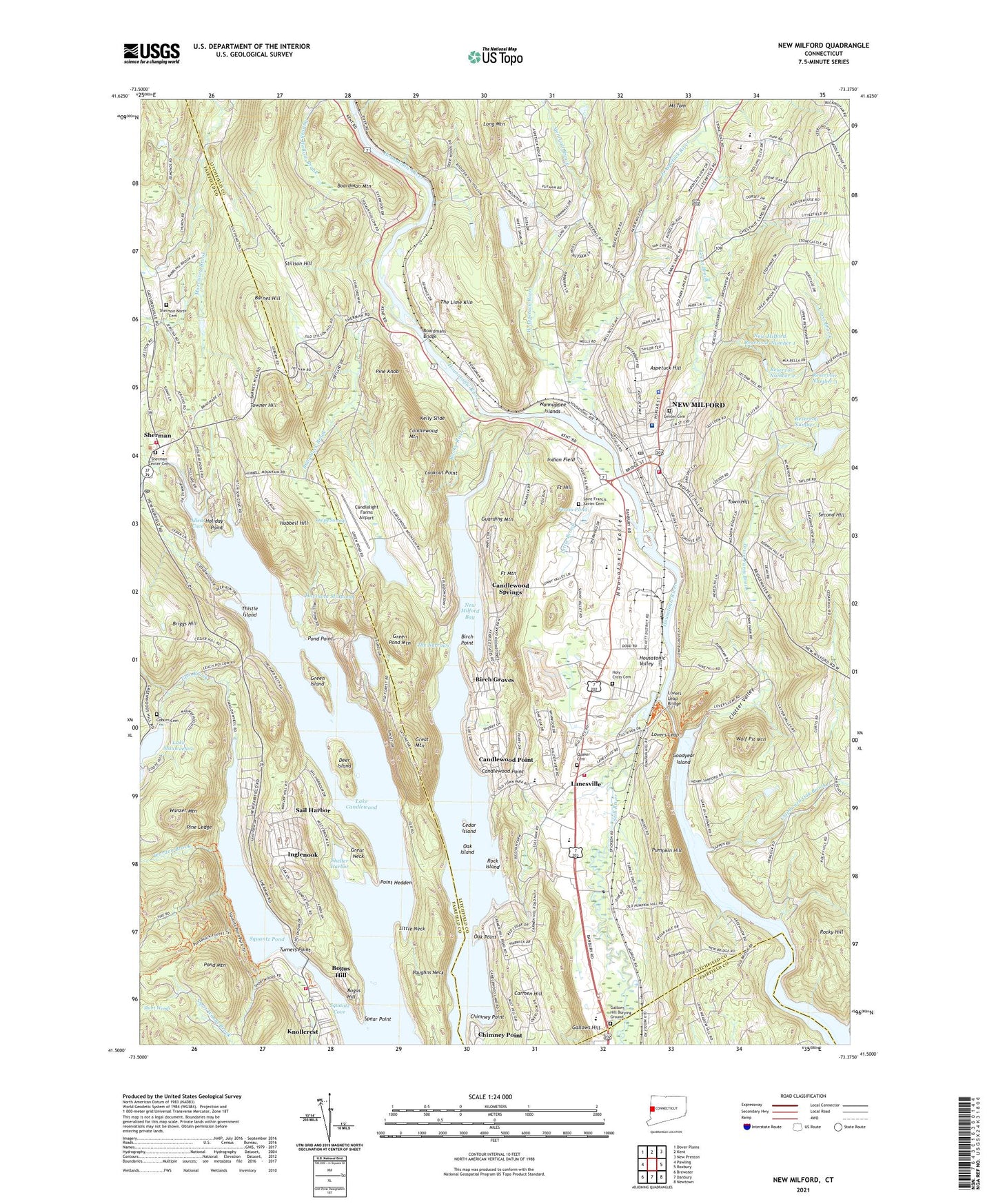
New Milford Connecticut US Topo Map
Couldn't load pickup availability
2024 topographic map quadrangle New Milford in the state of Connecticut. Scale: 1:24000. Based on the newly updated USGS 7.5' US Topo map series, this map is in the following counties: Litchfield, Fairfield. The map contains contour data, water features, and other items you are used to seeing on USGS maps, but also has updated roads and other features. This is the next generation of topographic maps. Printed on high-quality waterproof paper with UV fade-resistant inks.
Quads adjacent to this one:
West: Pawling
Northwest: Dover Plains
North: Kent
Northeast: New Preston
East: Roxbury
Southeast: Newtown
South: Danbury
Southwest: Brewster
This map covers the same area as the classic USGS quad with code o41073e4.
Contains the following named places: Addis Park, Allens Cove, Aspetuck Hill, Aspetuck Plain, Atchison Cove, Baldwin Park, Barnes Hill, Birch Groves, Birch Point, Bleachery Dam, Boardman Bridge, Boardman Mountain, Boardman School, Boardmans Bridge, Bogus Hill, Bogus Hill Census Designated Place, Briggs Hill, Bullymuck Brook, Camp Allen, Camp Ludington, Camp Mauwehu, Candlelight Farms Airport, Candlelight Heliport, Candlewood Lookout Tower, Candlewood Mountain, Candlewood Point, Candlewood Springs, Candlewood Trail, Candlewood Trails, Candlewood Valley Country Club, Canterbury School, Carmen Hill, Cedar Island, Center Cemetery, Chimney Point, Chimney Point Census Designated Place, Clapboard Oak Brook, Clatter Valley, Clatter Valley Park, Coburn Cemetery, Colonial Park, Cross Brook, Day Pond, Day Pond Dam, Deer Island, Docktors Field, East Aspetuck River, Ferris Pond, Finest Super Center Shopping Center, Fort Hill, Fort Mountain, Gallows Hill, Gallows Hill Burying Ground, Glen Brook, Goodyear Island, Great Brook, Great Mountain, Great Mountain Pond, Great Neck, Green Island, Green Pond, Green Pond Dam, Green Pond Mountain, Guarding Mountain, Haviland Millpond, Haviland Millpond Dam, Hill and Plain School, Hitchcock Mill Brook, Holiday Point, Holy Cross Cemetery, Housatonic River Reservoir, Housatonic Valley, Hubbell Hill, Hurds Corner, Indian Field, Inglenook, Inglenook Census Designated Place, John Pettibone Elementary School, Joyceland, Kelly Slide, Knollcrest Census Designated Place, Ladner Pond, Ladner Pond Dam, Lake Candlewood, Lake Candlewood Dam, Lake Candlewood Dike Number 2, Lake Mauweehoo, Lake Mauweehoo Dam, Lakeside Woods, Lakeside Woods Census Designated Place, Lanesville, Little Brook, Little Neck, Lookout Point, Lores Plaza Shopping Center, Lovers Leap, Lovers Leap Bridge, Lovers Leap State Park, Lynn Deming Park, Maplewood Industrial Park, Mead Corners, Merryall Brook, Mount Tom, New Milford, New Milford Bay, New Milford Census Designated Place, New Milford Center Historic District, New Milford Community Ambulance, New Milford Fire Marshal's Office, New Milford High School, New Milford Historical Society Museum, New Milford Hospital, New Milford Hospital Health Sciences Library, New Milford Police Department, New Milford Post Office, New Milford Public Library, New Milford Reservoir Number 1, New Milford Reservoir Number 2 Dam, New Milford Reservoir Number 3 Dam, New Milford Reservoir Number 4 Dam, New Milford Shopping Plaza Shopping Center, New Milford Town Hall, New Milford Volunteer Fire Department, Northville Elementary School, Oak Island, Oak Point, Park Lane, Pine Knob, Pine Ledge, Point Hedden, Pond Mountain, Pond Point, Pootatuck State Forest, Pumpkin Hill, Quaker Cemetery, Quipy Swamp, Reservoir Number 2, Reservoir Number 3, Reservoir Number 4, Rock Island, Rocky Hill, Rocky River, Sail Harbor, Sail Harbor Census Designated Place, Saint Francis Xavier Cemetery, Sawmill Brook, Shelter Harbor, Sherman, Sherman Census Designated Place, Sherman Center Cemetery, Sherman Church, Sherman Fire Marshal's Office, Sherman Library, Sherman North Cemetery, Sherman Post Office, Sherman School, Sherman Town Park, Sherman Volunteer Fire Department, Short Woods, Spear Point, Squantz Cove, Squantz Engine Company, Squantz Pond, Squantz Pond State Park, Still River, Stillson Hill, The Lime Kiln, The Narrows, Thistle Island, Tollgate Brook, Town Farm Brook, Town Hill, Town of New Milford, Town of Sherman, Towner Hill, Turners Point, Vaughns Neck, Wannuppee Islands, Wanzer Mountain, Water Witch Hose Company 1 Lanesville Station, Water Witch Hose Company 2 Grove Station, Wellsville, West Aspetuck River, Wolf Pit Mountain, Worden Brook, ZIP Codes: 06776, 06784