MyTopo
Danbury Connecticut US Topo Map
Couldn't load pickup availability
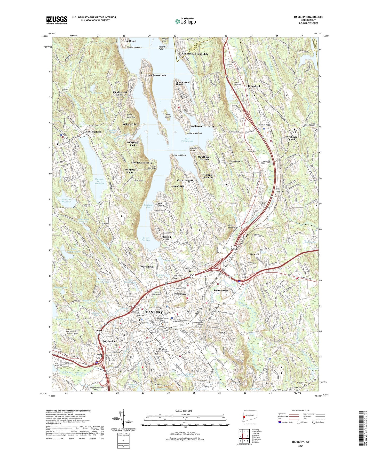
2024 topographic map quadrangle Danbury in the state of Connecticut. Scale: 1:24000. Based on the newly updated USGS 7.5' US Topo map series, this map is in the following counties: Fairfield, Litchfield. The map contains contour data, water features, and other items you are used to seeing on USGS maps, but also has updated roads and other features. This is the next generation of topographic maps. Printed on high-quality waterproof paper with UV fade-resistant inks.
Quads adjacent to this one:
West: Brewster
Northwest: Pawling
North: New Milford
Northeast: Roxbury
East: Newtown
Southeast: Botsford
South: Bethel
Southwest: Peach Lake
This map covers the same area as the classic USGS quad with code o41073d4.
Contains the following named places: Abbott Tech School, Aqua Vista, Arrowhead Point, Ball Pond Brook, Barn Plain Bridge, Bates Brook, Bear Mountain, Bear Mountain Reservation, Beaver Brook Mountain, Beaverbrook, Beckettville, Berkshire Shopping Center, Bethel High School, BIP Heliport, Bound Swamp, Broadview Middle School, Brook Center Shopping Center, Brookfield, Brookfield Center, Brookfield Center Census Designated Place, Brookfield Center Post Office, Brookfield Craft Center, Brookfield Fire Marshal's Office, Brookfield Golf Course, Brookfield High School, Brookfield Historical Society Building, Brookfield Junction, Brookfield Library, Brookfield Office Park, Brookfield Park Shopping Center, Brookfield Post Office, Brookfield Town Office, Cadndlewood Lake Golf and Country Club, Caldor Shopping Center, Candleview Ridge, Candlewood Boat and Beach Club, Candlewood Isle, Candlewood Isle Census Designated Place, Candlewood Knolls, Candlewood Knolls Census Designated Place, Candlewood Lake Club, Candlewood Lake Club Census Designated Place, Candlewood Orchards, Candlewood Orchards Census Designated Place, Candlewood Pines, Candlewood Plaza Shopping Center, Candlewood Shores, Candlewood Shores Census Designated Place, Cedar Heights, Center Elementary School, Central Cemetery, Charles Ives Center for the Performing Arts, Chatterton Point, Chimney Heights Shopping Center, Citizens Volunteer Hose Company 6, City of Danbury, Colonial Square Shopping Center, Commerce Park, Connecticut Department of Justice Centralized Library, Danbury, Danbury Bay, Danbury Fair Shopping Mall Shopping Center, Danbury Fairgrounds, Danbury High School, Danbury Hospital, Danbury Hospital Health Science Library, Danbury Hospital Heliport, Danbury Law Library, Danbury Museum and Historical Society, Danbury Museum and Historical Society Research Library, Danbury Public Library, Danbury Railroad Museum, Danbury Scott-Fanton Museum, Danbury Shopping Center, Danbury Town Park, Deer Hill, Dibbles Brook, Dickens Pond, Disbrow Pond, Doyles Pond, Driftwood Point, East Brook, East Lake Brook, East Lake Reservoir, East Lake Reservoir Dam, East Swamp, East Swamp Brook, Elmwood Cemetery, Fairfield County Courthouse, Fairwood Shopping Center, Forest Lake, Forest Lake Dam, Frank A Berry School, Germantown, Great Plain Cemetery, Great Plain School, Hatters Park, Hawthorne Terrace, Hayestown, Hayestown Avenue School, Hollywyle Park, Hop Brook, Hubb Shopping Center, Huckleberry Hill, Huckleberry Hill Elementary School, Immaculate High School, Immanuel Lutheran Cemetery, Immanuel Lutheran School, Joyce Corner, Kellners Pond, Kellogg Point, Kellogg Point Census Designated Place, Kenosia Trotting Park, King Lake, King Street Intermediate School, King Street Primary School, Kissen Brook, Knollcrest, Kohanza Brook, Lake Candlewood Dike, Lake Wackawana, Lattins Landing, Laure Hill Cemetery, Lees Pond Brook, Limekiln Brook, Lions Park, Locust Avenue School, Long Meadow Hill Junior High School, Lower Kohanza Dam, Lower Kohanza Lake, Lower Pine Cove, Main Street Historic District, Main Street Park, Main Street Post Office, Mann Brook, Marcus Hall, Margerie Lake Reservoir, Margerie Manor, Meckauer Park, Meeting House Hill School, Mercers Pond, Mercers Pond Dam, Merwin Brook, Military Museum of Southern New England, Mill Plain Cemetery, Mill Plain Swamp, Mill Ridge Intermediate School, Miry Brook, Morris Avenue School, Mountain End, Mountain View Cemetery, Never Sink Point, New Fairfield, New Fairfield Cemetery, New Fairfield Free Public Library, New Fairfield Post Office, New Fairfield Shopping Center, New Fairfield Town Hall, New Hope Christian School, New Street School, North Street Shopping Center, Nutmeg Square Shopping Center, Old Grays Bridge, Old Main Street Cemetery, Old Mill Pond, Orchard Industrial Park, Orchard Point, Padanaram Brook, Padanaram Reservoir, Padanaram Reservoir Dam, Park Avenue School, Parks Pond Brook, Pembroke Cemetery, Pembroke School, Peter Piper School, Pine Island, Pleasant Acres, Plumtrees Plaza Shopping Center, Plumtrees School, Pocono Point, Ridgewood Country Club, Roberts Avenue School, Rogers Park, Rogers Park Middle School, Rogers Park Pond, Rogers Pond, Route 6 Mailroom Post Office, Route 6 Shopping Center, Ruth A Haas Library, Sacred Heart School, Saint Gregorys School, Saint Josephs School, Saint Peters Cemetery, Saint Peters School, Saint Platons Orthodox Cemetery, Shelter Rock, Shelter Rock School, Sherman Bridge, Short Woods Brook, Silvermine Industrial Park, Snug Harbor, South Street School, Stadley Rough School, Stony Hill, Stony Hill Brook, Sweet Cake Mountain, Sympaug Brook, Ta'agan Point, Town Hill, Town of Brookfield, Town of Danbury, Town of New Fairfield, Town Park, Turtle Pond, United Jewish Center Cemetery, Upper Kohanza Dam, Upper Kohanza Lake, West Brook, West Lake Reservoir Dam, Western Connecticut State University, Western Connecticut State University Westside Campus, WFAR-FM (Danbury), Whisconier Middle School, White Turkey Plaza Shopping Center, Wildmans Landing, Williams Park, WINE-AM (Brookfield), Wolf Pit Brook, Wooster Cemetery, Wooster Street Cemetery, WRKI-FM (Brookfield), WXCI-FM (Danbury), ZIP Codes: 06804, 06811, 06812