MyTopo
Stafford Springs Connecticut US Topo Map
Couldn't load pickup availability
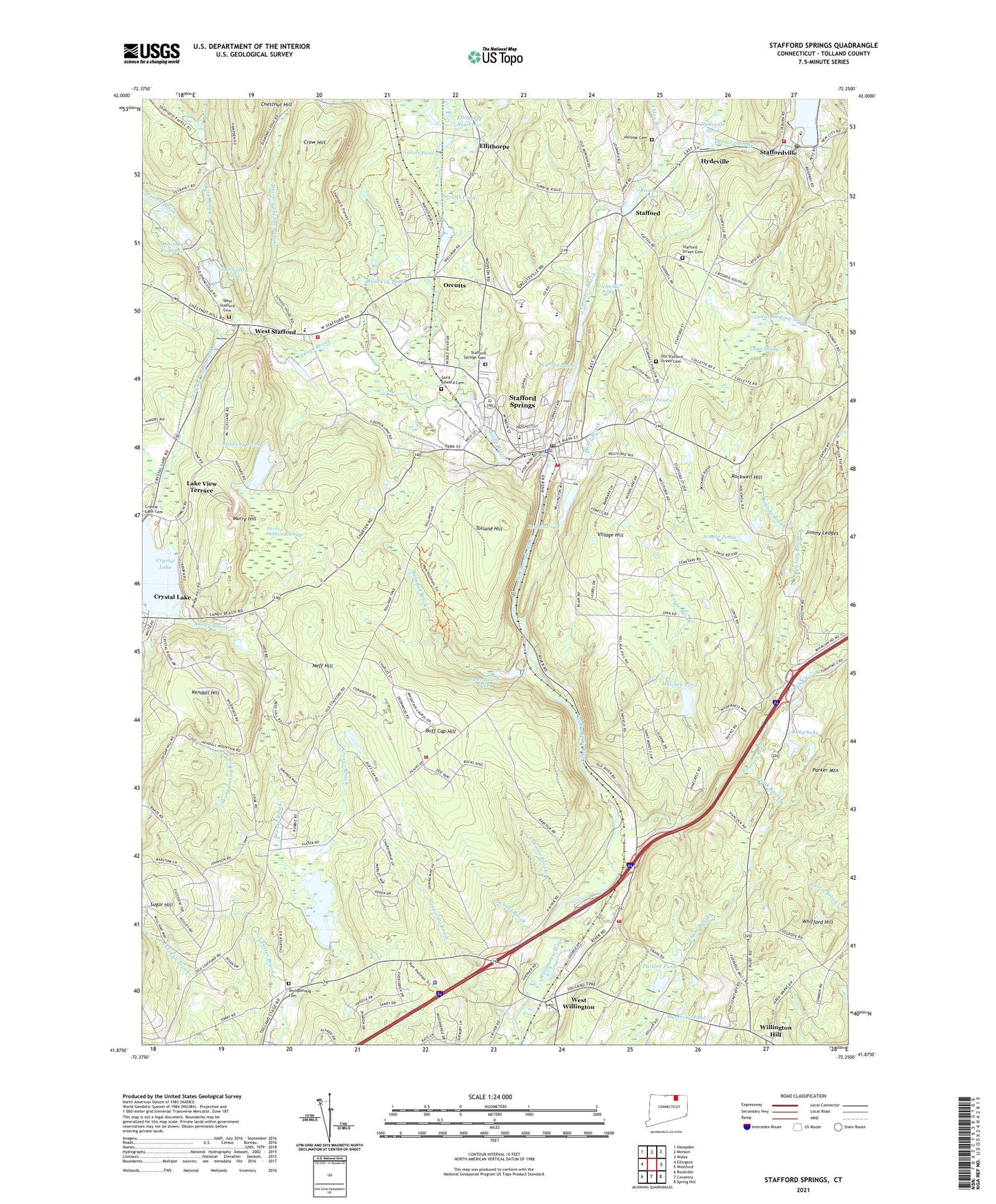
2024 topographic map quadrangle Stafford Springs in the state of Connecticut. Scale: 1:24000. Based on the newly updated USGS 7.5' US Topo map series, this map is in the following counties: Tolland. The map contains contour data, water features, and other items you are used to seeing on USGS maps, but also has updated roads and other features. This is the next generation of topographic maps. Printed on high-quality waterproof paper with UV fade-resistant inks.
Quads adjacent to this one:
West: Ellington
Northwest: Hampden
North: Monson
Northeast: Wales
East: Westford
Southeast: Spring Hill
South: Coventry
Southwest: Rockville
This map covers the same area as the classic USGS quad with code o41072h3.
Contains the following named places: Aborn Brook, Alden Brook, Arnold Ponds, Baker Brook, Bonemill Brook, Bradway Dam, Bradway Pond, Bradway Pond Dam, Brandy Brook, Brooks Brook, Buff Cap Hill, Cedar Swamp, Charter Brook, Connecticut State Police Troop C - Tolland, Crow Hill, Crystal Lake, Crystal Lake Brook, Crystal Lake Dam, Dennis Pond, Dennis Pond Dam, Deversky Pond, Devils Hopyard Swamp, Diamond Ledge Brook, Edson Brook, Ellis Brook, Ellis Brook Reservoir, Ellis Dam, Ellithorpe, Ellithorpe Dam, Ellithorpe Reservoir, Foster Pond, Frink Brook, Furnace Brook, Ginholt Pond, Glenville Pond, Glenville Pond Dam, Grapeville Brook, Grover Brook, Halchek Pond, Halchek Pond Dam, Hatch Brook, Hillside Cemetery, Hydeville, Hydeville Pond, Hydeville Pond Dam, Jimmy Ledges, Keene Brook, Kendall Hill, Kent Hollow Dam, Labonte Brook, Lake View Terrace, McIntyres Brook, Memorial Hall, Middle River, Murry Hill, Neff Hill, Nye-Holman State Forest, Old Stafford Street Cemetery, Orcutts, Orcutts Pond, Orcutts Pond Dam, Parizek Pond, Parizek Pond Dam, Parker Mountain, Patten Brook, Rhode Island Millponds, Rhode Island Ponds Dam, Riverside Pond, Riverside Pond Dam, Roaring Brook, Rockwell Hill, Ruby Brook, Ruby Lake, Saint Edward Cemetery, School Brook, Shenipsit Dam, Shenipsit Reservoir, Skungamaug Cemetery, Skungamaug Marsh, Springs Dam, Springs Pond, Stafford, Stafford Ambulance Association, Stafford Fire Department 1 Station 145, Stafford Fire Department 1 Station 245, Stafford Police Department, Stafford Springs, Stafford Springs Cemetery, Stafford Springs Census Designated Place, Stafford Street Cemetery, Staffordville, Staffordville Post Office, Staffordville Reservoir Dam, Stoughton Brook, Sugar Hill, Sun Valley Lake, Sun Valley Lake Dam, Sweetheart Lake, Sweetheart Lake Dam, Swift Airport, Tolland Fire Department Station 440, Tolland Hill, Town of Stafford, Town of Tolland, Town of Willington, Village Hill, Warren Pond, Warren Pond Dam, West Stafford, West Stafford Cemetery, West Stafford Fire Department Station 44, West Willington, Whifford Hill, Whitney Dam, Whitney Reservoir, Willington Fire Department 1 Station 113, Willington Hill, ZIP Codes: 06076, 06084, 06279