MyTopo
Brunswick West Georgia US Topo Map
Couldn't load pickup availability
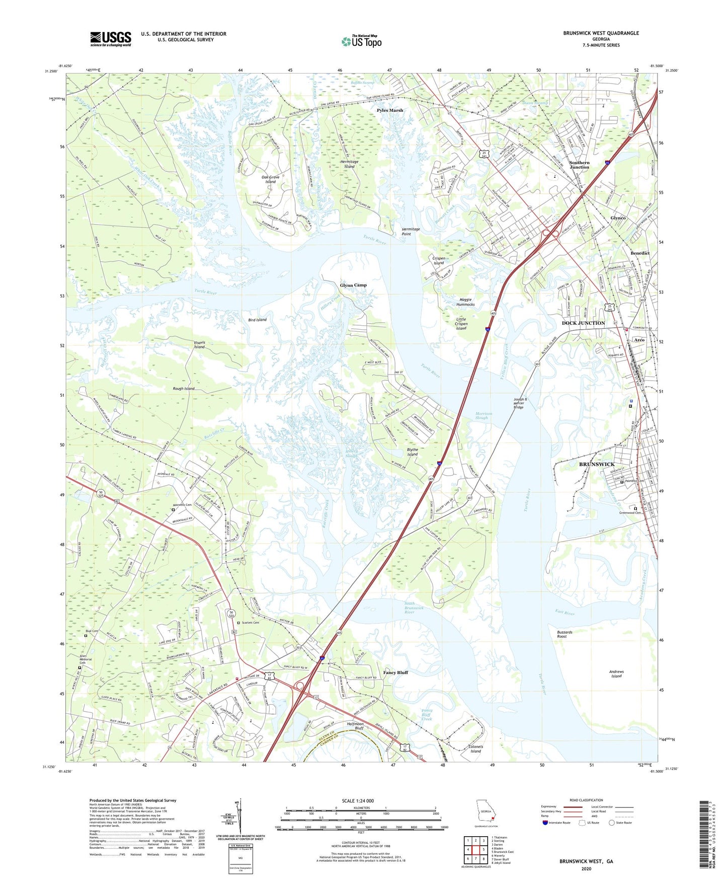
2024 topographic map quadrangle Brunswick West in the state of Georgia. Scale: 1:24000. Based on the newly updated USGS 7.5' US Topo map series, this map is in the following counties: Glynn, Camden. The map contains contour data, water features, and other items you are used to seeing on USGS maps, but also has updated roads and other features. This is the next generation of topographic maps. Printed on high-quality waterproof paper with UV fade-resistant inks.
Quads adjacent to this one:
West: Bladen
Northwest: Thalmann
North: Sterling
Northeast: Darien
East: Brunswick East
Southeast: Jekyll Island
South: Dover Bluff
Southwest: Waverly
This map covers the same area as the classic USGS quad with code o31081b5.
Contains the following named places: Academy Creek, Allen Memorial Cemetery, Andrews Island, Antioch Church, Arco, Arco Baptist Church, Arco Park, Arco School, Arco United Methodist Church, Atlantic Village Mobile Home Park, Ballard Community Building, Ballard Elementary School, Ballard Park, Benedict, Bethel Church, Bird Island, Blue Cemetery, Blythe Island, Blythe Island Church, Blythe Island County Park, Blythe Island Park, Brunswick Academy Creek Water Pollution Control Plant, Brunswick Church of God, Brunswick Landing Marina, Brunswick Primitive Baptist Church, Brunswick West Shopping Center, Buffalo Creek, Buffalo River, Burnett Creek, Buzzards Roost, Camp Tolochee, Christian Renewal Academy, Church of God, Clover Heights, Cornerstone Baptist Church, Cowpen Creek, Cox, Crispen Island, Dankel Chapel, Deerwood, Dillard Creek, Dixon Swamp, Dock Junction, Dock Junction Census Designated Place, Driftwood Mobile Home Park, Ellis Point, Emanuel Church, Emmanuel Christian School, Family Life Assembly of God Church, Fancy Bluff, Fancy Bluff Creek, Fancy Bluff Park, Fellowship Methodist Church, First African Church, Fourth Street School, Galilee Church, Gibson Creek, Glendale Gardens, Glenwood Estates, Glynco, Glyndale, Glyndale Church, Glyndale Elementary School, Glynn Camp, Glynn County Detention Center, Glynn County Fire Department Station 1, Glynn County Fire Department Station 6, Glynn County Sheriff's Office, Glynn Heights, Golden Isles Christian Church, Golden Isles Church of God, Golden Isles Elementary School, Gordon Heights, Greenland Church, Greenwood Cemetery, Greer School, Halfmoon Bluff, Hermitage Island, Hermitage Point, High Hill Lake, Highland Park, Hillery Creek, Hillery Slough, Hopewell Creek, Joseph B Mercer Bridge, Kingdom Hall of Jehovahs Witnesses, Lake Side Church, Little Buffalo Creek, Little Crispen Island, Maggie Hummocks, Marshes of Glynn Baptist Church, Maxwells Cemetery, Morrison Slough, Northwood Estates, Oak Bluff, Oak Grove Island, Oak Grove Island Golf and Country Club, Open Bible Church, Outlets Limited Mall Shopping Center, Palmetto Cemetery, Parade Rest, Parkwood, Pine Ridge, Pine Ridge Baptist Church, Pinehurst, Postal Plus Contract Postal Unit, Pyles Marsh, Ratcliffe Creek, Revival Church of Jesus Christ, Ridgewood Plantation, Rough Island, Satilla Marsh Elementary School, Satilla Shores, Scarlett Cemetery, Seldon Park, Shady Acres, Shady Acres Mobile Home Park, South Brunswick River, Southern Junction, Springfield Church, Springhill Church, Taylors Chapel, Timber Landing, Trinity Church, Turtle River Park, Visavis Island, Way of the Cross Church, WGIG-AM (Brunswick), White Oak Creek, WPIQ-AM (Brunswick), WXMK-FM (Dock Junction), Yellow Bluff Creek, ZIP Code: 31523