MyTopo
Darien Georgia US Topo Map
Couldn't load pickup availability
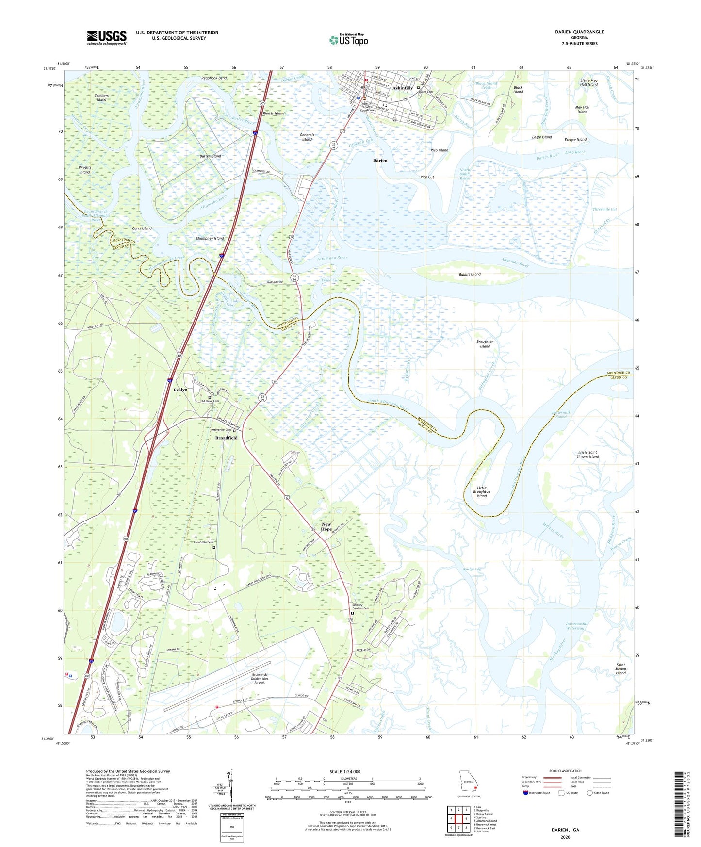
2024 topographic map quadrangle Darien in the state of Georgia. Scale: 1:24000. Based on the newly updated USGS 7.5' US Topo map series, this map is in the following counties: Glynn, McIntosh. The map contains contour data, water features, and other items you are used to seeing on USGS maps, but also has updated roads and other features. This is the next generation of topographic maps. Printed on high-quality waterproof paper with UV fade-resistant inks.
Quads adjacent to this one:
West: Sterling
Northwest: Cox
North: Ridgeville
Northeast: Doboy Sound
East: Altamaha Sound
Southeast: Sea Island
South: Brunswick East
Southwest: Brunswick West
This map covers the same area as the classic USGS quad with code o31081c4.
Contains the following named places: Altamaha Plantation, Bel-Air, Bible Baptist Church, Black Island, Black Island Creek, Boys Estate, Broadfield, Broughton Island, Brunswick Golden Isles Airport, Brunswick-Altamaha Canal, Butler Cemetery, Butler Island, Butler River, Buttermilk Sound, Cambers Island, Carrs Island, Catfish Creek, Cathead Creek, Champney Island, Champney River, City of Darien, Columbus Square, Darien, Darien Creek, Darien Police Department, Darien Post Office, Darien Public School, Darien Volunteer Fire Department, Eagle Island, Elizafield Plantation, Escape Island, Evelyn, Faith Church, First African Baptist Church, First Baptist Church, First Methodist Church, First Presbyterian Church, Fort King George State Historic Site, Freedman Cemetery, Fridaycap Creek, Generals Cut, Generals Island, Georgia State Patrol Troop I Post 23 Brunswick, Glynn County Fire Department Station 5, Glynn County Fire Department Station 8, Glynn County Police Department, Grace Baptist Church, Grant Chapel Presbyterian Church, Greer Elementary School, Hammersmith Creek, Hofwyl, Hopeton Plantation, Ida Hilton Free Library, Indian Cemetery, Jefferson Square, Lighthouse Baptist Church, Little Broughton Island, Little May Hall Island, Long Reach, Marshes-of-Mackay, May Hall Creek, May Hall Island, McIntosh County Courthouse, Mcintosh County Middle School, Memory Gardens Cemetery, Needwood Church, Needwood Middle School, New Hope, New Hope Creek, New Hope Mobile Home Park, North End, North-South Reach, Oak Grove Intermediate School, Oglethorpe Manor, Oglethorpe Square, Old Slave Cemetery, Petersville Cemetery, Pico Cut, Pico Island, Pine Street Christian School, Piney Island, Rabbit Island, Reaphook Bend, Rhetts Island, Saint Andrews Episcopal Church, Saint Cyprians Church, Saint Johns Baptist Church, South Altamaha River, Threemile Cut, Vernon Baptist Church, Vernon Square, Vernon Square-Columbus Square Historic District, Wallys Leg, Wilson Creek, Wood Cut