MyTopo
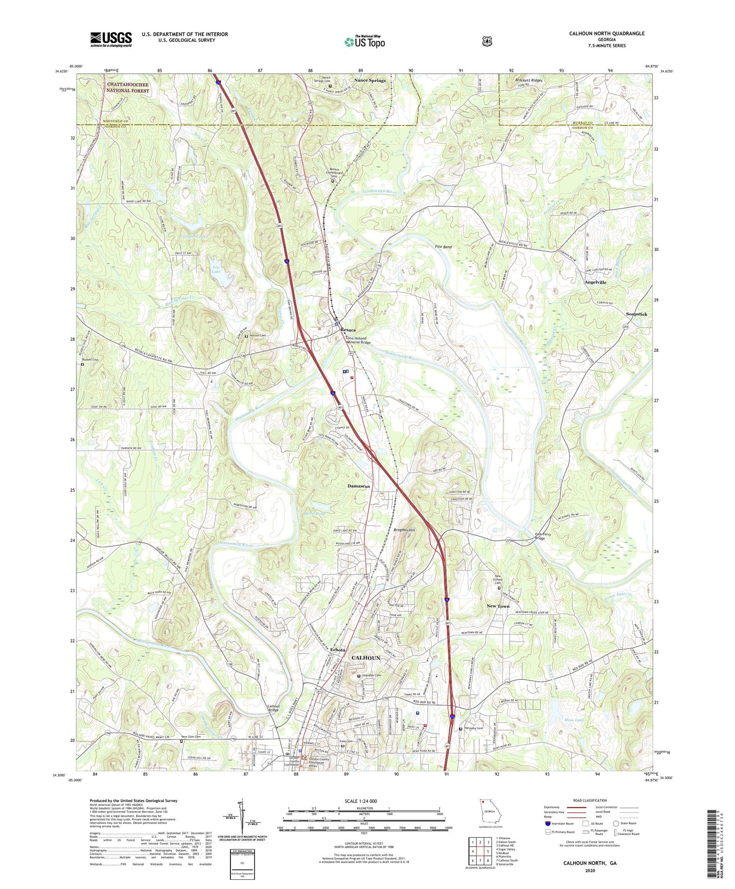
Calhoun North Georgia US Topo Map
Couldn't load pickup availability
Also explore the Calhoun North Forest Service Topo of this same quad for updated USFS data
2024 topographic map quadrangle Calhoun North in the state of Georgia. Scale: 1:24000. Based on the newly updated USGS 7.5' US Topo map series, this map is in the following counties: Gordon, Whitfield, Murray. The map contains contour data, water features, and other items you are used to seeing on USGS maps, but also has updated roads and other features. This is the next generation of topographic maps. Printed on high-quality waterproof paper with UV fade-resistant inks.
Quads adjacent to this one:
West: Sugar Valley
Northwest: Villanow
North: Dalton South
Northeast: Calhoun NE
East: Redbud
Southeast: Sonoraville
South: Calhoun South
Southwest: Plainville
This map covers the same area as the classic USGS quad with code o34084e8.
Contains the following named places: Angelville, Ashwood Church, Ashworth Middle School, Bethlehem Church, Blue Springs Creek, Brogdon Hill, Calhoun, Calhoun Academy, Calhoun Bridge, Calhoun City Hall, Calhoun Downtown Historic District, Calhoun Ferry, Calhoun Fire Department Station 3, Calhoun High School, Calhoun Learning Center, Calhoun North Industrial Park, Calhoun Police Department, Calhoun Post Office, Calhoun-Gordon County Library, Camp Creek, Chandler Cemetery, Cherokee Indian Memorial, Clem Holland Memorial Bridge, Conasauga River, Coosawattee River, Corinth Church, Crane Eater Creek, Damascus, Damascus Baptist Church, David Pond, Dead Mans Branch, Dry Creek, Eastside Elementary School, Echota, Echota Baptist Church, Fain Cemetery, Faith Tabernacle, First Baptist Church of Calhoun, Fite Bend, Fites Ferry, Fork Ferry Bridge, Fricks Ferry, Gideon Church, Gordon Central High School, Gordon County, Gordon County Courthouse, Gordon County Fire and Rescue Department Station 5, Gordon County Health Center, Gordon County Jail, Gordon County Sheriff's Office, Gordon Hospital, Graham Creek, Gus Moore Airport, Hall Memorial Church, Harmony Cemetery, Harmony Church, Horton Cemetery, Jesus Church, Lands Ferry, Langford Lake, Langford Lake Dam, Lee Lake, Lee Lake Dam, Lick Creek, Moss Lake, Moss Lake Dam, Mount Zion Church, Nance Springs, Nance Springs Cemetery, New Echota Cemetery, New Echota Church, New Echota Historical Site, New Town, New Town Church, New Zion Baptist Church, New Zion Cemetery, Newtown Ferry, North Georgia Seminary, Oothkalooga Creek, Polecat Creek, Printup School, Resaca, Resaca Cemetery, Resaca Church, Resaca Confederate Cemetery, Resaca Ferry, Resaca Police Department, Resaca Post Office, Resaca School, Riverview Baptist Church, Rowland Hill School, Russell Cemetery, Russell Church, Saint James Espiscopal Church, Soapstick, Stephens School, Tolbert Elementary School, Town Creek, Town of Resaca, Water Valley, Zack Airport, ZIP Code: 30735