MyTopo
Chestatee Georgia US Topo Map
Couldn't load pickup availability
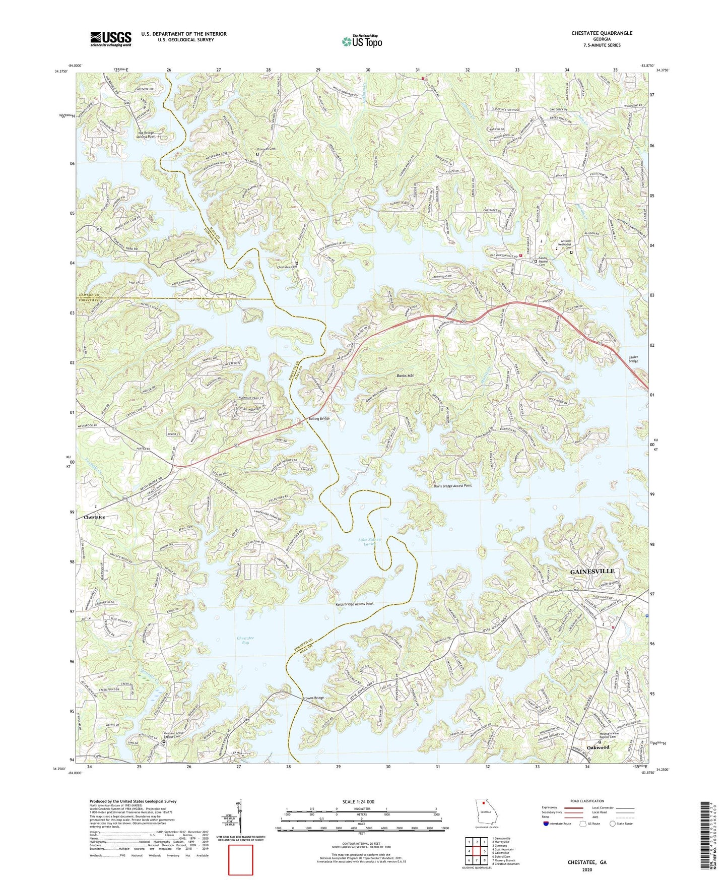
2024 topographic map quadrangle Chestatee in the state of Georgia. Scale: 1:24000. Based on the newly updated USGS 7.5' US Topo map series, this map is in the following counties: Hall, Forsyth, Dawson. The map contains contour data, water features, and other items you are used to seeing on USGS maps, but also has updated roads and other features. This is the next generation of topographic maps. Printed on high-quality waterproof paper with UV fade-resistant inks.
Quads adjacent to this one:
West: Coal Mountain
Northwest: Dawsonville
North: Murrayville
Northeast: Clermont
East: Gainesville
Southeast: Chestnut Mountain
South: Flowery Branch
Southwest: Buford Dam
This map covers the same area as the classic USGS quad with code o34083c8.
Contains the following named places: Absalom, Antioch Campground, Antioch Church, Antioch Methodist Cemetery, Balus Creek, Balus Creek Access Point, Banks Mountain, Barnes, Beach Haven Heights, Bethel Tabernacle, Bolding Bridge, Bolling Bridge, Bolling Mill Access Point, Browns Bridge, Cameron Point, Canaan Church, Cherokee Hills, Cherokee Trail, Chestatee, Chestatee Bay, Chestatee Cemetery, Chestatee Church, Chestatee Elementary School, Chestatee High School, Chestatee Middle School, Chestatee North, Chestatee River, Cool Springs Access Point, Crown Point, Davis Bridge Access Point, Duckett Mill Access Point, Fox Trace, Fran Mar Heights, Gainesville Church, Gainesville Park Access Point, Goddards Old Ford, Hall County Fire Station 13, Hall County Fire Station 4, High Hill School, Holiday Heights, Holiday Hills, Johnson Creek, Johnson Creek Access Point, Keith Bridge, Keith Bridge Access Point, Keith Ferry, Lake Farm, Lake Ranch, Lanier Bridge, Lanier Church, Lanier Northwest, Latham Creek, Latham Creek Access Point, Latham Creek Heliport, Little Hall Park, Long Hollow Access Point, Looper Lake, Maple Forge, Martin Creek, Mayfield Church, McEver, McEver Elementary School, Mill Ridge, Moore, Mountain View, Mountain View Access Point, Mountain View Baptist Cemetery, Mountain View Church, Mundys Point, New Hope Church, New Hope United Methodist Church Cemetery, Nix Bridge Access Point, North Georgia Detention Center, Open Door Church, Pine Forest, Pine Haven, Pine Hills, Pinecrest Heights, Pleasant Grove Baptist Cemetery, Pleasant Grove Church, Pleasant Hill Church, Point View Landing, Prospect Cemetery, Prospect Church, Reed, River Forks Park, Robinson Access Point, Rocky Bottom Ford, Sardis Baptist Cemetery, Sardis Church, Sardis Creek, Sardis Creek Access Point, Sardis Elementary School, Sardis School, Sardis Shores, Serene Shores, Shallow Ford, Sidney on Lanier, Simpson Access Point, South Hall Church, Springdale, Springdale Forest, Summer Point, Tanner, Taylor Creek, Thompson Creek, Trudy, Twin Rivers, Upper Latham Creek Access Point, Venture Cove, Vickers, War Hill Park, Weatherford, Westview, White, Whitmire, Wildcat Creek Access Point, WKZD-AM (Murrayville), Wolfs Head, Wooley Ford, ZIP Codes: 30504, 30506