MyTopo
Kennesaw Georgia US Topo Map
Couldn't load pickup availability
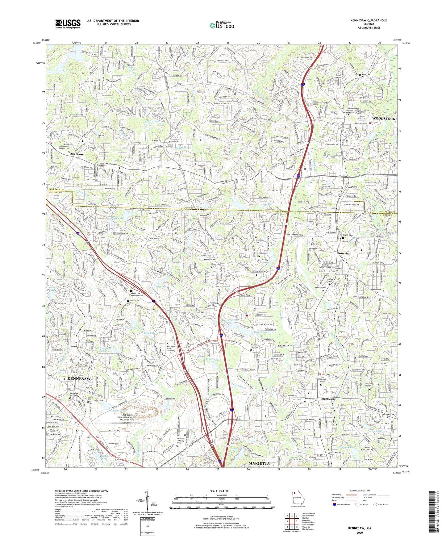
2024 topographic map quadrangle Kennesaw in the state of Georgia. Scale: 1:24000. Based on the newly updated USGS 7.5' US Topo map series, this map is in the following counties: Cobb, Cherokee. The map contains contour data, water features, and other items you are used to seeing on USGS maps, but also has updated roads and other features. This is the next generation of topographic maps. Printed on high-quality waterproof paper with UV fade-resistant inks.
Quads adjacent to this one:
West: Acworth
Northwest: Allatoona Dam
North: South Canton
Northeast: Canton
East: Mountain Park
Southeast: Sandy Springs
South: Marietta
Southwest: Lost Mountain
This map covers the same area as the classic USGS quad with code o34084a5.
Contains the following named places: Abington Green, Adams Park, Addison Heights, Allatoona Pass, Arden Lake, Ashley Forest, Audubon Forest, Baker Elementary School, Barrett Crosssing Shopping Center, Bascomb Commercial Park, Bascombs Springs, Bazeman Lake, Bell Industrial Park, Bells Ferry Elementary School, Bells Ferry Landing Shopping Center, Bells Ferry Park, Bells Ferry Place, Bell-Star Mine, Big Shanty Elementary School, Big Shanty Village Historic District, Blackwell Cemetery, Blackwell Chase, Blackwell Elementary School, Blackwell Square Shopping Center, Bozeman Lake Dam, Breeze Hill Estates, Brookwood Estates, Buice Lake, Buice Lake Dam, Cambria Hills, Camp Kiwanis, Canterberry Park, Cardinal Woods, Chalker Elementary School, Chapman Intermediate School, Charlotte F Lockhart Academy, Chastains Lakes, Chattahoochee Technical College Woodstock Campus, Cherokee Commons Shopping Center, Cherokee Estates, Cherokee Forest, Cherokee Mobile Home Park, Cherokee South, Cherokee Street Historic District, Chestnut Hill, City of Kennesaw, City of Woodstock, Clark Lake, Clark Lake Dam, Cobb County International Airport-McCollum Field, Cobb Place Manor, Cobb Place Shopping Center, Colony Woods, Cross Creek, Crossroads Village Shopping Center, Daniell Middle School, Dawson Cemetery, Deerfield, Dixie Industrial Park, Dixie Speedway, Dobbs Estates, Duncans Lake, Duncans Lake Dam, E T Booth Middle School, East Chastain Lake, East Chastain Lake Dam, Eastgate Mobile Home Park, Edwards - Attaway Cemetery, Ellison Lake, Enon Cemetery, Etowah High School, Falcon Hills, Farmland Lake, Farmland Lake Dam, First Baptist Christian School, Fowler Cemetery, Franklin - Hamilton Cemetery, Frey Lake, Furtah Preparatory School, Gibson Acres, Giles Crossing, Glenell, Gresham Cemetery, Hamby Place, Henderson Cemetery, Heritage Farms, Heritage Place, Hickory Forest, Hinton Cemetery, Independence Walk, Indian Valley Estates, Jamerson Forest, Joshua Landing, Kell High School, Kellogg Creek, Kellogg Creek Day Use Area, Kellogg Creek North, Kennesaw, Kennesaw Charter School, Kennesaw City Cemetery, Kennesaw Crossing Shopping Center, Kennesaw Quarry, Kennesaw State University, Kennesaw State University Census Designated Place, Kennesaw Station Shopping Center, Kincaid Elementary School, Kingridge Estates, Kingridge North, Kingridge West, Kings Crossing, Lafayette Academy, Lake Forest, Lake Latimer, Lake Pointe, Lakeside Hills, Land of Lakes, Lansdowne, Latimer Cemetery, Laura Lake, Laura Lake Dam, Little Noonday Creek, Market Square Shopping Center, Martha J Moore Transitional Learning Center, McCleskey Middle School, Mctract Lake Dam, Mill Creek, Motes Hill, Mount Arbor Cemetery, Mount Zion Methodist Cemetery, Nelson Lake, New Chastain Corners Shopping Center, Nicholson Elementary School, Noonday, Noonday Cemetery, Noonday Christian Academy, Noonday Creek Park, Noonday Creek Structure Number 15 Dam, Noonday Creek Structure Number 16 Dam, Noonday Creek Structure Number 17 Dam, Noonday Creek Structure Number Four Dam, Noonday Creek Structure Number Nine Dam, North Bridge Trace, North Cobb Industrial Park, North Main Street Historic District, Northridge Estates, Nowlin Estates, Nowlin Station, Oak Creek Estates, Oak Grove, Oak Grove Cemetery, Oak Grove Elementary School, Oak Grove Estates, Old Ebenezer Cemetery, Old Noonday Cemetery, Old Sandy Plains Cemetery, Outlets Limited Mall Shopping Center, Parkway Business Center, Parkwood Commons, Pathways Academy, Payne Campground, Payne Public Use Area, Pine Hill, Pine Valley Farms, Pinetree Country Club, Pinetree Country Club Dam, Pinetree Country Club Lake, Ponder Cemetery, Posey Branch, Powell Station, Primrose School of Wade Green, Ridgewood Estates, Roberts Cemetery, Rolling Hills Memory Gardens Cemetery, Rubes Creek, Saint Catherine of Siena Catholic School, Sardis Cemetery, Savanna Place, Shadowbrook, Shadowood Mobile Home Park, Shallowford Forest, Shaw Park, Sherwood Forest, Shiloh Cemetery, Shiloh Hills Christian School, Shiloh Square Shopping Center, Skyridge, South Cherokee Industrial Park, Southfork, Spring Valley Mobile Home Park, Springfield, Stir Up Manor, Stockwood Estates, Sturbridge, Summers Street Historic District, Sumpter Ridge, Tate Cemetery, Tate Creek, Teem Lake, Teem Lake Dam, The Arbors, The Crossroads, The Woodlands, The Woods at Colony Crossing, Timberlake North, Town Center at Cobb Shopping Center, Town Center Prado Shopping Center, Town Center Village Shopping Center, Towncenter Mall, Towne Lake Square Shopping Center, Tyson Estates, Village Green, Wade Green Crossing Shopping Center, West Chastain Lake, West Chastain Lake Dam, Westside Office Center, Wiggly Lake, Wiggly Lake Dam, Willow Creek, Wood Glen, Woodstock, Woodstock Commons Shopping Center, Woodstock Division, Woodstock Elementary School, Woodstock High School, Woodstock Hospital, Woodstock Place Shopping Center, Woodstock Square Shopping Center, Woodstock Station, Woodstock Village Shopping Center, Woodwind Station, Wooten Lake, Wooten Lake Dam, ZIP Codes: 30066, 30144, 30189