MyTopo
Canton Georgia US Topo Map
Couldn't load pickup availability
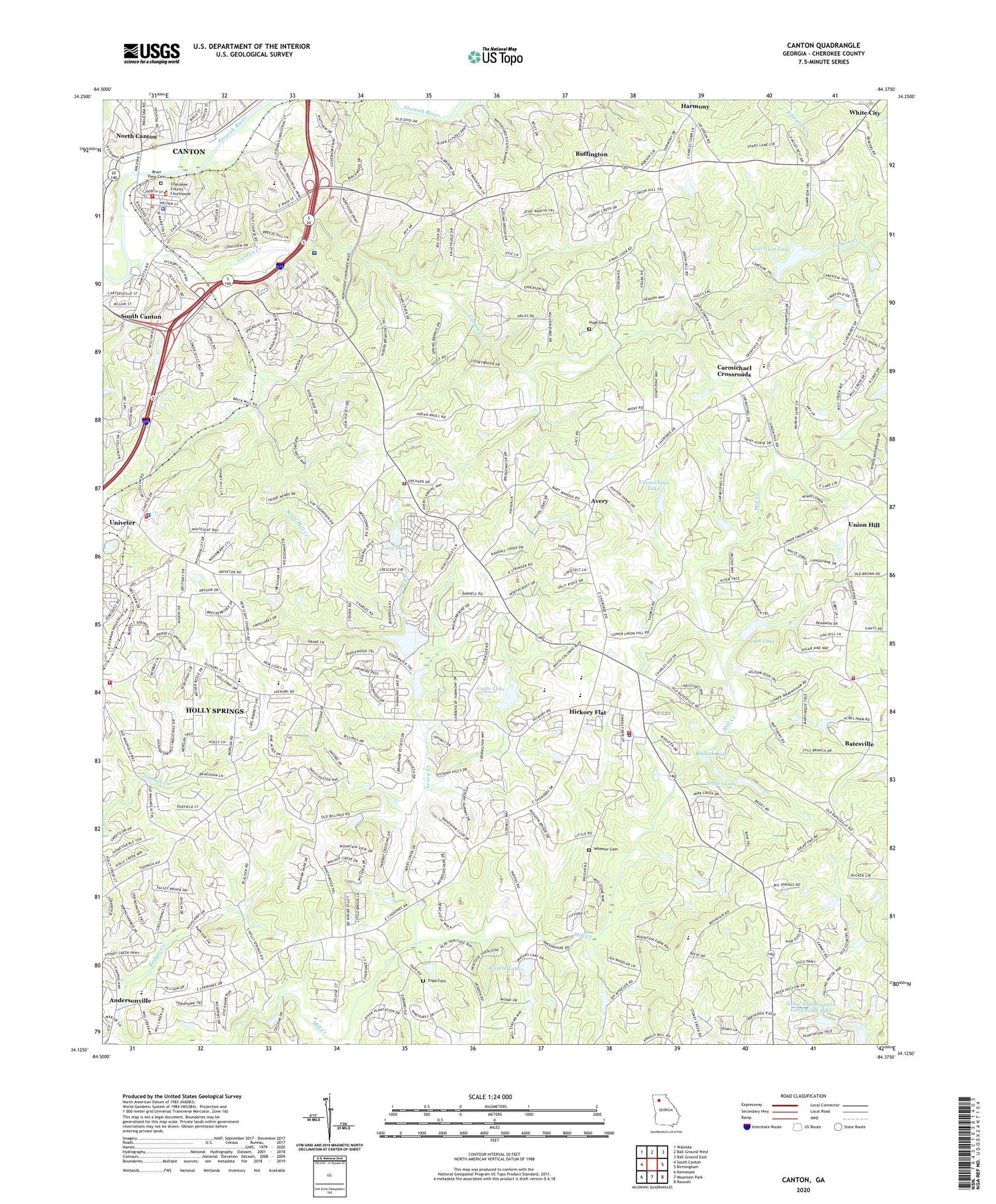
2024 topographic map quadrangle Canton in the state of Georgia. Scale: 1:24000. Based on the newly updated USGS 7.5' US Topo map series, this map is in the following counties: Cherokee. The map contains contour data, water features, and other items you are used to seeing on USGS maps, but also has updated roads and other features. This is the next generation of topographic maps. Printed on high-quality waterproof paper with UV fade-resistant inks.
Quads adjacent to this one:
West: South Canton
Northwest: Waleska
North: Ball Ground West
Northeast: Ball Ground East
East: Birmingham
Southeast: Roswell
South: Mountain Park
Southwest: Kennesaw
This map covers the same area as the classic USGS quad with code o34084b4.
Contains the following named places: Andersonville, Antioch Church, Avery, Avery Creek, Avery Elementary School, Batesville, Big Springs Church, Blalock Lake, Blalock Lake Dam, Bradshaw Lake, Bradshaw Lake Dam, Brown Park, Buffington, Buffington Church, Buffington Elementary School, Cagle Lake, Canton, Canton City Hall, Canton Commerical Historic District, Canton Country Club, Canton Creek, Canton Fire Department Station 16, Canton Grammar School, Canton High School, Canton Historic District, Canton Mill Commons Shopping Center, Canton Police Department, Canton Public School, Canton Village Shopping Center, Carmichael Crossroads, Carmichael Lake, Carmichael Lake Dam, Cherokee County, Cherokee County Administration Building, Cherokee County Adult Detention Center, Cherokee County Board of Education, Cherokee County Courthouse, Cherokee County Fire and Rescue, Cherokee County Fire Station 8, Cherokee County Marshal's Office, Cherokee County Public Safety Building, Cherokee County Sheriff East Precinct, Cherokee County Sheriff's Office - Hickory Flat Precinct, Cherokee County Sheriff's Office Headquarters, Cherokee Estates Lake Dam, Church of God, City of Canton, City of Holly Springs, Dean Rusk Middle School, First Baptist Church, First Methodist Episcopal Church South, Garrison Lake, Georgia Station Patrol Post 28 Police Station, Great Southeastern Land Fund Lake, Gymnastics Recreation Center, Harmon Field, Harmony, Hasty Elementary School, Hickory Flat, Hickory Flat Church of God, Hickory Flat Elementary School, Hickory Flat Fire Department Station 23, Hickory Flat Fire Department Station 3, Hickory Flat Fire Department Station 32, Hickory Flat Village Shopping Center, Hickory Grove Shopping Center, Holly Springs Division, Holly Springs Elementary School, Indian Knoll Baptist Church, Johnston Elementary School, Kenney Askew County Park, Lacy Lake, Lacy Lake Dam, Lusk Lake, Mill Canton Creek Structure Number 10 Dam, Mill Canton Creek Structure Number 12 Dam, Mill Canton Creek Structure Number Four Dam, Mill Canton Creek Structure Number Seven Dam, Mill Canton Creek Structure Number Six Dam, Mill Creek Church, Mount Helen Church, Mount Zion Baptist Church, Mountain Road Elementary School, New Covenant Church, New Hope Church, New Light Church, North Canton, Northside Hospital Cherokee Campus, Philadelphia Church, Promised Land Church, Pugh Cemetery, R T Jones Memorial Hospital, River View Cemetery, Riverdale School, Riverplace Shopping Center, Riverstone Mill Shopping Center, Saint Paul Cemetery, Scott Mill Creek, Sellers Lake, Sellers Lake Dam, Sequoyah High School, Shady Hook Shopping Center, Shiloh Methodist Church, Stringer Airport, Tripp Cemetery, Union Arbor Church, Union Hill, Waters Lake, Waters Lake Dam, Wheeler Cemetery, White City, Word of Life Church, Zion Baptist Church, ZIP Code: 30115