MyTopo
Kingsland Georgia US Topo Map
Couldn't load pickup availability
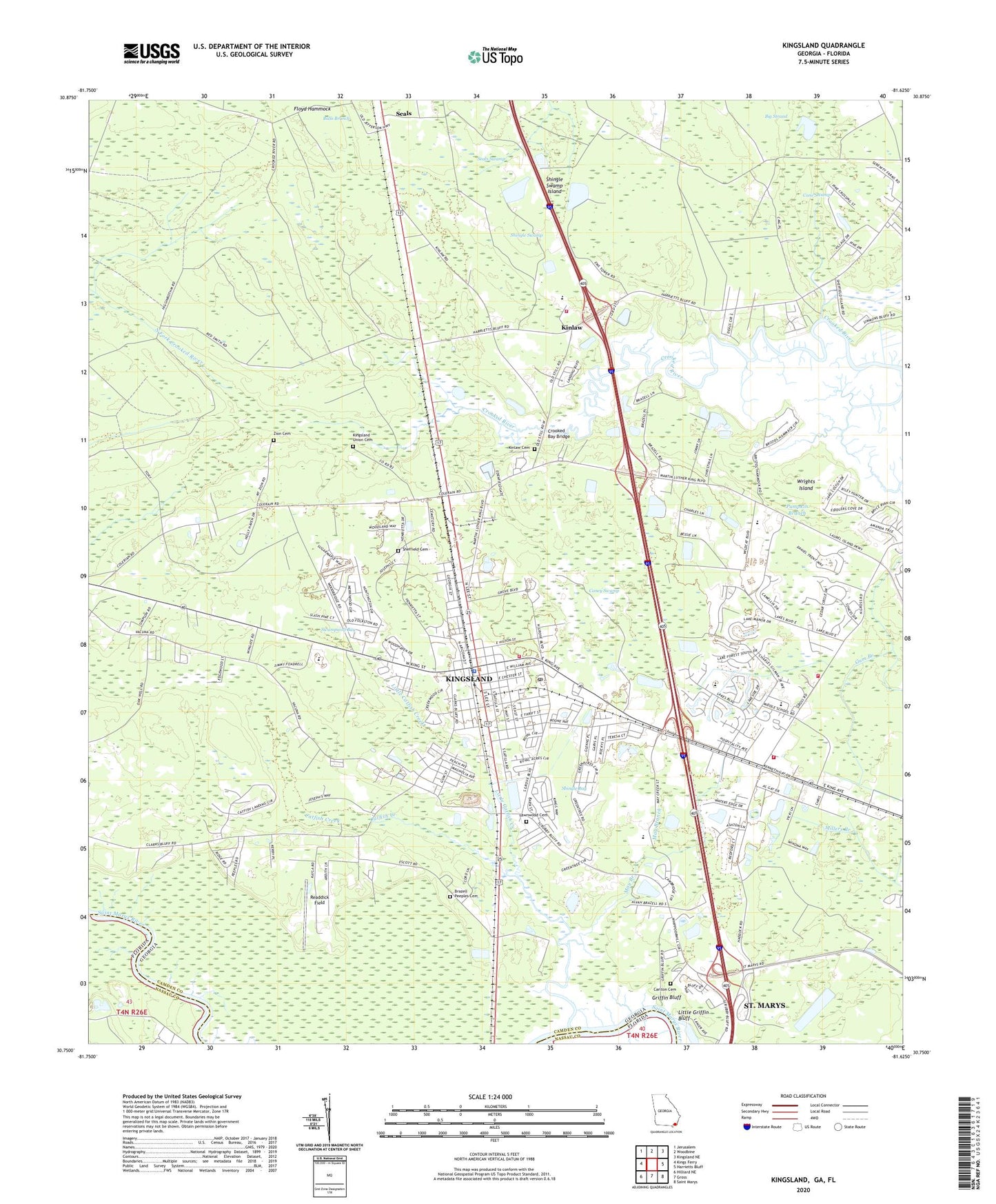
2024 topographic map quadrangle Kingsland in the state of Georgia. Scale: 1:24000. Based on the newly updated USGS 7.5' US Topo map series, this map is in the following counties: Camden, Nassau. The map contains contour data, water features, and other items you are used to seeing on USGS maps, but also has updated roads and other features. This is the next generation of topographic maps. Printed on high-quality waterproof paper with UV fade-resistant inks.
Quads adjacent to this one:
West: Kings Ferry
Northwest: Jerusalem
North: Woodbine
Northeast: Kingsland NE
East: Harrietts Bluff
Southeast: Saint Marys
South: Gross
Southwest: Hilliard NE
This map covers the same area as the classic USGS quad with code o30081g6.
Contains the following named places: Big Strand, Brazell Peeples Cemetery, Bristol Hammock, Camden Corners Shopping Center, Camden County Fire / Rescue Station 13, Camden County Fire / Rescue Station 14, Camden County Fire Rescue Station 10, Camden County Fire Rescue Station 3, Camden County Fire Rescue Station 4, Camden County Fire Rescue Station 5, Camden County High School, Camden County High School Ninth Grade Center, Camden County Public Library, Camden Free Will Baptist Church, Camden Middle School, Camden Point Mobile Home Park, Camden Woods Shopping Center, Caney Branch, Caney Swamp, Carlton Cemetery, Carnegie Chapel, Catfish Acres, Catfish Creek, Coastal Academy, Creekwood, Crooked Bay Bridge, David L Rainer Elementary School, Deals Landing, Deer Run, Evergreen Church, Fawnwood, First African Baptist Church, First Baptist Church of Kingsland, First United Pentecostal Church, Floyd Hammock, Forest Ridge, Friendship Baptist Church, Greentree, Greenville School, Griffin Bluff, Gross Still, Harrietts Bluff Village, Hidden Treasures Assembly of God Church, Kingsland, Kingsland City Hall, Kingsland Elementary School, Kingsland First United Methodist Church, Kingsland Police Department, Kingsland Post Office, Kingsland Shopping Center, Kingsland Union Cemetery, Kingsland Water Pollution Control Plant, Kinlaw, Kinlaw Cemetery, Lawnwood Cemetery, Little Catfish Creek, Little Griffin Bluff, Longwood Plantation, Mamie Lou Gross Elementary School, Martin Glen, Matilda Harris Elementary School, May Branch, May Creek, New Wave of Glory Church, North Fork Crooked River, Oakwood Homes Mobile Home Park, Palmetto Pines Mobile Home Park, Pumpkin Branch, Readdick Field, Ruhamah School, Saint Paul African Methodist Episcopal Church, Scotchville School, Scrubby Bluff School, Seals, Seals Swamp, Sheffield Cemetery, Shingle Bay, Shingle Swamp, Shingle Swamp Island, Southern Pines Mobile Home Park, Swampwolf Bay, Terra Haute, The Lakes, The Meadows, Vacuna, WHJX-FM (Brunswick), WIOI-FM (Brunswick), WKBX-FM (Kingsland), Wolfbay, Woodhaven, Woodland Mobile Home Estates, Wrights Island, Wrights Plantation, Zion Cemetery, Zion Church, ZIP Code: 31548