
MyTopo
La Grange Georgia US Topo Map
Couldn't load pickup availability
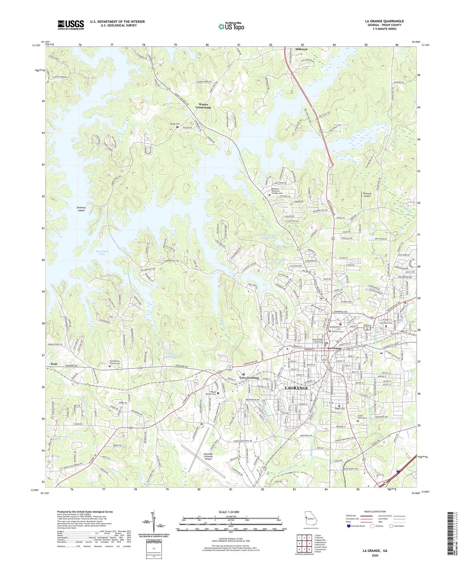
2024 topographic map quadrangle La Grange in the state of Georgia. Scale: 1:24000. Based on the newly updated USGS 7.5' US Topo map series, this map is in the following counties: Troup. The map contains contour data, water features, and other items you are used to seeing on USGS maps, but also has updated roads and other features. This is the next generation of topographic maps. Printed on high-quality waterproof paper with UV fade-resistant inks.
Quads adjacent to this one:
West: Abbottsford
Northwest: Glenn
North: Hillcrest
Northeast: Hogansville
East: Mountville
Southeast: Hilyer
South: Cannonville
Southwest: Lanett North
This map covers the same area as the classic USGS quad with code o33085a1.
Contains the following named places: American Legion Golf Club, Arbor Grove Baptist Church, Ashling Place, Ayres Memorial Church, Beaver Cove, Beech Creek, Bellevue, Berta Weathersbee Elementary School, Bethel Methodist Church, Broad Street Historic District, Brookstone Estates, Brookwood, Callaway Auditorium, Callaway Center, Callaway Lake, Callaway Lake Dam, Callaway Memorial Tower, Callaway Park, Callaway Stadium, Cameron Cove, Camp Smith, Cannon Street Elementary School, Central Baptist Church, Church of Christ, Church of God, City of LaGrange, Clark Recreation Area, Coleman Library, Concord Church, Congregational Bethel, Creek Ridge, Dallas Church, Dallas Street Community Building, Dawson Street Christian School, Dix Store, Dixie Community Center, Dixie Creek, Dixie Methodist Church, Dunson Baptist Church, Dunson Methodist Church, Dunson Mills School, Eagles Rest, East Depot Street School, East La Grange Baptist Church, East La Grange Christian Church, East Vernon Church Cemetery, East Vernon Missionary Baptist Church, East View Cemetery, Ethel W Kight Library, Ethel W Kight Magnet School, Fernwood, First Baptist Church, First Methodist Church, First Presbyterian Church, First Presbyterian Montessori School, First Primitive Baptist Church, First United Methodist School, Foxcroft, Franklin Forest Elementary School, Franklin Road Church, Granger Park, Greenwich Woods Estates, Harwell Avenue School, Highland Marina Recreation Area, Highlands Country Club, Hill Street Junior High School, Hillcrest Elementary School, Hillside Congregational Christian Church, Hillview Cemetery, Holiness Church, Hollis Hand Elementary School, Holly Hill, Hutchins Lake Dam, Jackson Creek, Jackson Street Holiness Church, Jones Street School, Kelly School, La Grange, La Grange Boys Junior High School, La Grange City Hall, La Grange Memorial Library, La Grange Waterworks, Lafayette Christian School, LaGrange Academy, LaGrange College, LaGrange Division, Lagrange Fire Department Station 2, Lagrange Fire Department Station 3, LaGrange High School, LaGrange Police Department, LaGrange Post Office, LaGrange-Callaway Airport, Lake Forest Hills, Lake West Point Estates, Lees Crossing, Lees Crossing Shopping Center, Leete Hill Memorial Methodist Episcopal Church, Louise Anderson Manget Hall, McGee Bridge Recreation Area, Meadowlands, Moody Cemetery, Moss Creek, Mount Beulah Baptist Church, Mount Beulah Cemetery, Mount Beulah School, Newnan Development Dam North, Newnan Development Dam South, Newnan Development Lake North, Newnan Development Lake South, North Ridge, Oakside Christian School, Oakside Church, Ogletree Park, Pentecostal Holiness Church, Pepperell Park, Pilgrims Rest Church, Pinehaven Estates, Piney Hills, Piney Hills Lake, Piney Woods Lake, Pitts Hall, Restlawn Memorial Gardens Cemetery, Richards Airport, Richardson Chapel Christian Methodist Episcopal Church, Rising Grove Church, Riverview, Riverwood, Rockwell Estates, Rogers Cemetery, Saint Elizabeth Mission School, Saint Johns Methodist Church, Saint Marks Episcopal Church, Saint Peters Catholic Church, Samuel C Dobbs Hall, Sassafrass Hills, Second Baptist Church, Seventh Day Adventist Church, Shadowlawn Cemetery, Sherwood Lake, Shoal Creek, Shoal Creek Church, Smith Hall, Smyrna Church, Solomon Grove Baptist Church, Sound Doctrine Christian Academy, South View Cemetery, Southwest La Grange Baptist Church, Southwest School, Spring Valley, Stallings, Sturbridge, Sunny Point, Sunny Point Recreation Area, Sunnyside Church, Swanson Island, Tatum School, Teaver Hill, Teavers Store, The Crossings, The Crossroads, Thomastown School, Trinity Methodist Church, Troup County, Troup County Courthouse, Troup County High School, Troup County Marshal's Office, Union Street Baptist Church, United Congregational Christian Church, United Pentecostal Church, Unity Baptist Church, Unity Elementary School, Unity Methodist Church, Unity Park, Valley Grove Baptist Church, View Pointe, Ward Chapel, Ware Street Baptist Church, Wares Crossroads, Warren Temple Methodist Episcopal Church, Waterford Place, Wellstar West Georgia Medical Center, West Georgia Cancer Clinic, West Georgia Medical Center Heliport, West Georgia Technical College, West Side Magnet School, West Wind, West Wyngate, Western Heights Church, Wheelers Store, Whitesville Road Elementary School, Whitesville Road Middle School, Whitesville Street Methodist Church, Wildwood, William Banks Library, William H Turner Hall, Willow Crest Lake, Willowcrest, WLAG-AM (La Grange), Wolf Creek, Woodfield, WTRP-AM (La Grange), Yellowjacket Creek, Yellowjacket Creek Recreation Area, Young Acres, Youngs Pond, Zion Hill Baptist Church, ZIP Code: 30240


