MyTopo
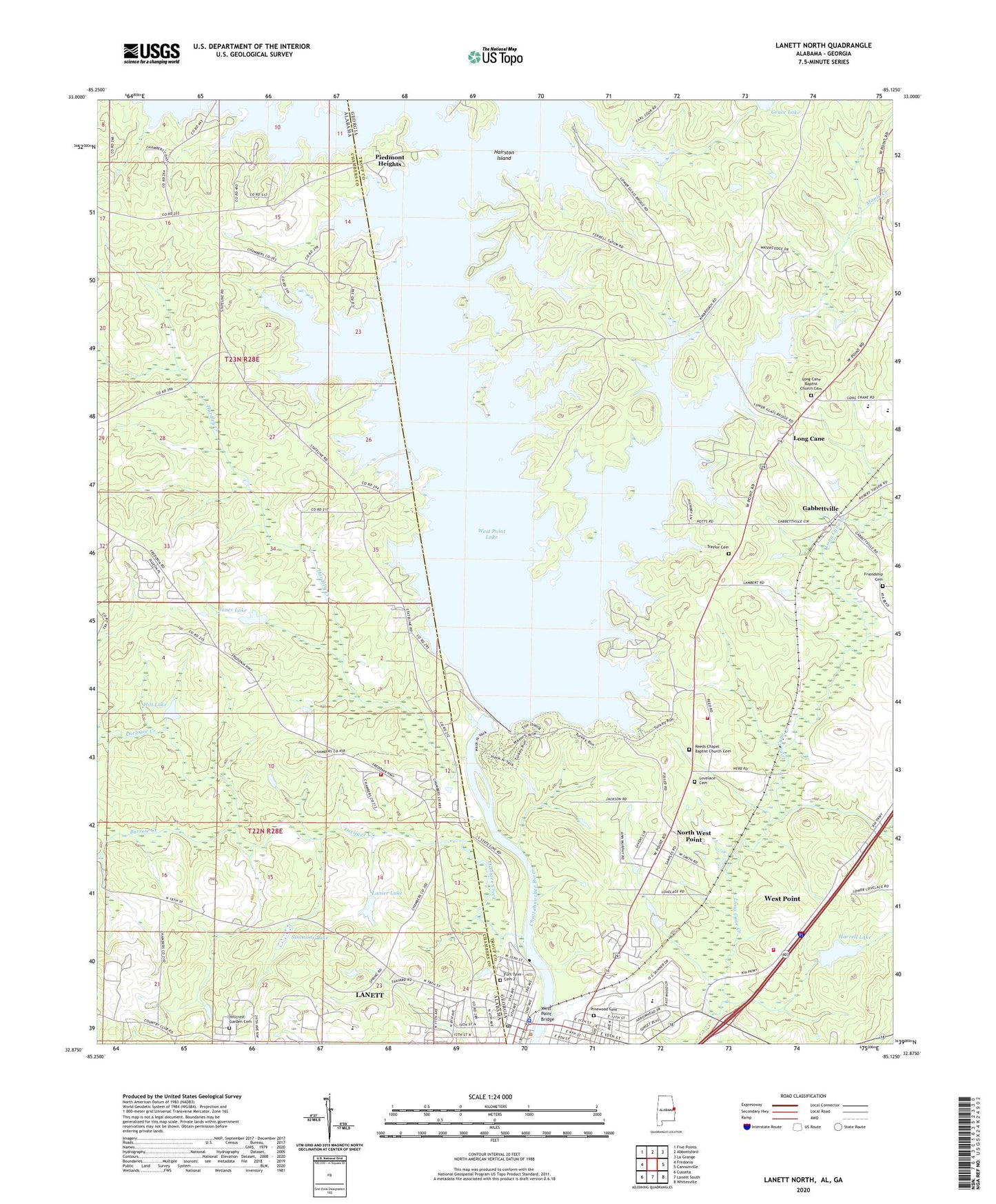
Lanett North Alabama US Topo Map
Couldn't load pickup availability
2024 topographic map quadrangle Lanett North in the states of Georgia, Alabama. Scale: 1:24000. Based on the newly updated USGS 7.5' US Topo map series, this map is in the following counties: Chambers, Troup. The map contains contour data, water features, and other items you are used to seeing on USGS maps, but also has updated roads and other features. This is the next generation of topographic maps. Printed on high-quality waterproof paper with UV fade-resistant inks.
Quads adjacent to this one:
West: Fredonia
Northwest: Five Points
North: Abbottsford
Northeast: La Grange
East: Cannonville
Southeast: Whitesville
South: Lanett South
Southwest: Cusseta
Contains the following named places: Amity Park, Barrow Creek, Bethel Church, Bethlehem Baptist Church, Bird Creek Recreation Area, Burnt Village Marina, Burnt Village Park, Center School, City of West Point, Earl Cook Recreation Area, Ebernezer Baptist Church, Emmanuel Chapel Methodist Church, Evening Spring Church, First Baptist Church, First Christian Church, Fort Tyler Cemetery 2, Friendship Cemetery, Friendship Church, Gabbettville, Grace Dam, Grace Lake, Hairston Island, Hardley Creek, Hardley Creek Recreation Area, Harrell Lake, Harrell Lake Dam, Hawkes Childrens Library of West Point, Hill Lake, Hillcrest Garden Cemetery, Jones Dam, Jones Lake, Lakeview Fire and Rescue, Lanier Baptist Church, Lanier Dam, Lanier Lake, Lanier Memorial Church, Long Cane, Long Cane Baptist Church, Long Cane Baptist Church Cemetery, Long Cane Elementary School, Long Cane Methodist Church, Long Cane Middle School, Long Game Recreation Area, Lovelace Cemetery, Maple Creek, Maple Creek Park, North West Point, Oakland Recreation Park, Old Atkinson Crossing, Oseligee Creek, Piedmont Heights, Pine Grove School, Pinewood Cemetery, Potts Road Recreation Area, R Shaefer Heard Park, Reeds Chapel, Reeds Chapel Baptist Church Cemetery, Rocky Point Recreation Area, Rocky Point Recreational Area, Saint John Church, Saint Paul African Methodist Episcopal Church, Saint Paul Church, Sardis Church, Simmons Dam, Simmons Lake, Tenth Street School, Timmons Dam, Timmons Lake, Traylor Cemetery, Troup County Fire Department Station 6, Tyler Estates, Valley Hospital, Veasey Creek Recreation Area, Veasey Park Picnic Area, WCJM-FM (West Point), Webb Dam, Webb Lake, Wehadkee Creek, West Lake Recreation Area, West Over Look Area, West Point, West Point Bridge, West Point City Hall, West Point Dam, West Point Elementary School, West Point Fire Department, West Point First Christian Church, West Point High School, West Point Lake, West Point Police Department, West Point Post Office, West Point Presbyterian Church, West Point Waterworks, WPLV-AM (West Point)