MyTopo
Milstead Georgia US Topo Map
Couldn't load pickup availability
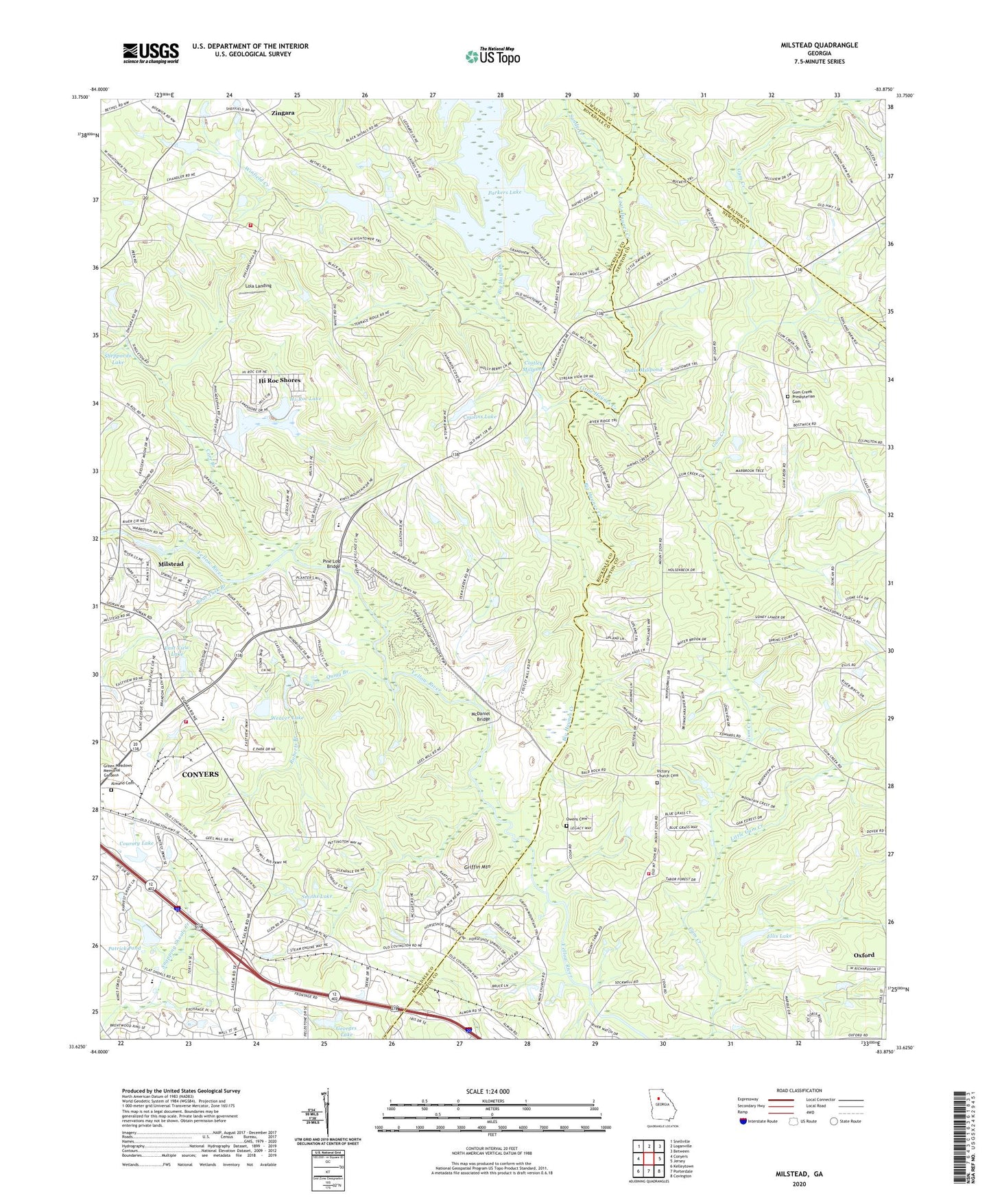
2024 topographic map quadrangle Milstead in the state of Georgia. Scale: 1:24000. Based on the newly updated USGS 7.5' US Topo map series, this map is in the following counties: Rockdale, Newton, Walton. The map contains contour data, water features, and other items you are used to seeing on USGS maps, but also has updated roads and other features. This is the next generation of topographic maps. Printed on high-quality waterproof paper with UV fade-resistant inks.
Quads adjacent to this one:
West: Conyers
Northwest: Snellville
North: Loganville
Northeast: Between
East: Jersey
Southeast: Covington
South: Porterdale
Southwest: Kelleytown
This map covers the same area as the classic USGS quad with code o33083f8.
Contains the following named places: Almand Cemetery, Ashley Grove, Baby Farms Church, Ball Rock Church, Big Haynes Creek, Big Haynes Creek Recreation Area, Boar Tusk Branch, Cambridge Forest, Carr Branch, Cedar Grove Church, Cedar Grove School, Church in the Now, City of Conyers, Conyers Church of God, Conyers Commerce Center, Conyers Plaza Shopping Center, Conyers Waterworks, Costley Mill, Costley Millpond, Coursey Lake, Coursey Lake Dam, Cousins Lake, Cousins Lake Dam, Dial Mill, Dials Millpond, Double Springs Church, East View Lake, East View Lake Dam, Ellis Lake, Fieldstone Plaza Shopping Center, First Shady Grove Baptist Church, Flat Shoals Elementary School, Gee Mill, Gees Mill Business Park, Georges Lake, Georges Lake Dam, Georgia International Horse Park, Gethsemane Baptist Church, Griffin Mountain, Gum Creek Church, Gum Creek Presbyterian Cemetery, Hi Roc Shores, Hightower Forest, Hightower Indian Trail Monument, Hightower Trail Elementary School, Hi-Roc Community Church, Hi-Roc Lake, Hi-Roc Lake Dam, Horseshoe Springs, Hyde Chapel, Jack Turner Dam, Lake Brooks, Lake Brooks Dam, Lakeside Baptist Church, Little Gum Creek, Little Haynes Creek, Lola Landing, McDaniel Bridge, Milstead, Milstead Baptist Church, Milstead Census Designated Place, Milstead Crossing Shopping Center, Milstead United Methodist Church, Mount Olive Baptist Church, Mount Tabor Church, Mount Zion Church, Newton County Fire Station 9, North Conyers Farms, North Rockdale Baptist Church, North Rockdale Division, Oakland School, Owens Cemetery, Park 20 East Industrial Park, Parkers Lake, Patrick Pond, Peachtree Academy Main Campus, Pentecost Church, Philadelphia Church, Pine Log Bridge, Pine Log Park, Princeton, Quigg Branch, Randy Poynter Lake, Roberts Branch, Rock Mill Fish Hatchery, Rockdale County Animal Shelter, Rockdale County Fire Department Station 1, Rockdale County Fire Department Station 5, Rockdale Lake, Rockdale Lake Dam, Saint Simon's Episcopal Church, Salem Baptist Church, Sandy Creek, Sarasota Commerce Center, Shady Grove School, Sheppards Lake, Sheppards Lake Dam, Smiths Lake, Spring Valley, Summer Hills Church, Tabernacle Church, The Rocks, Twin Haynes Creek, Victory Church Cemetery, Water Oak Church, Weaver Lake, Weaver Lake Dam, Westminster Church, Winfield Creek, Zingara, ZIP Code: 30013