MyTopo
Mulky Gap Georgia US Topo Map
Couldn't load pickup availability
Also explore the Mulky Gap Forest Service Topo of this same quad for updated USFS data
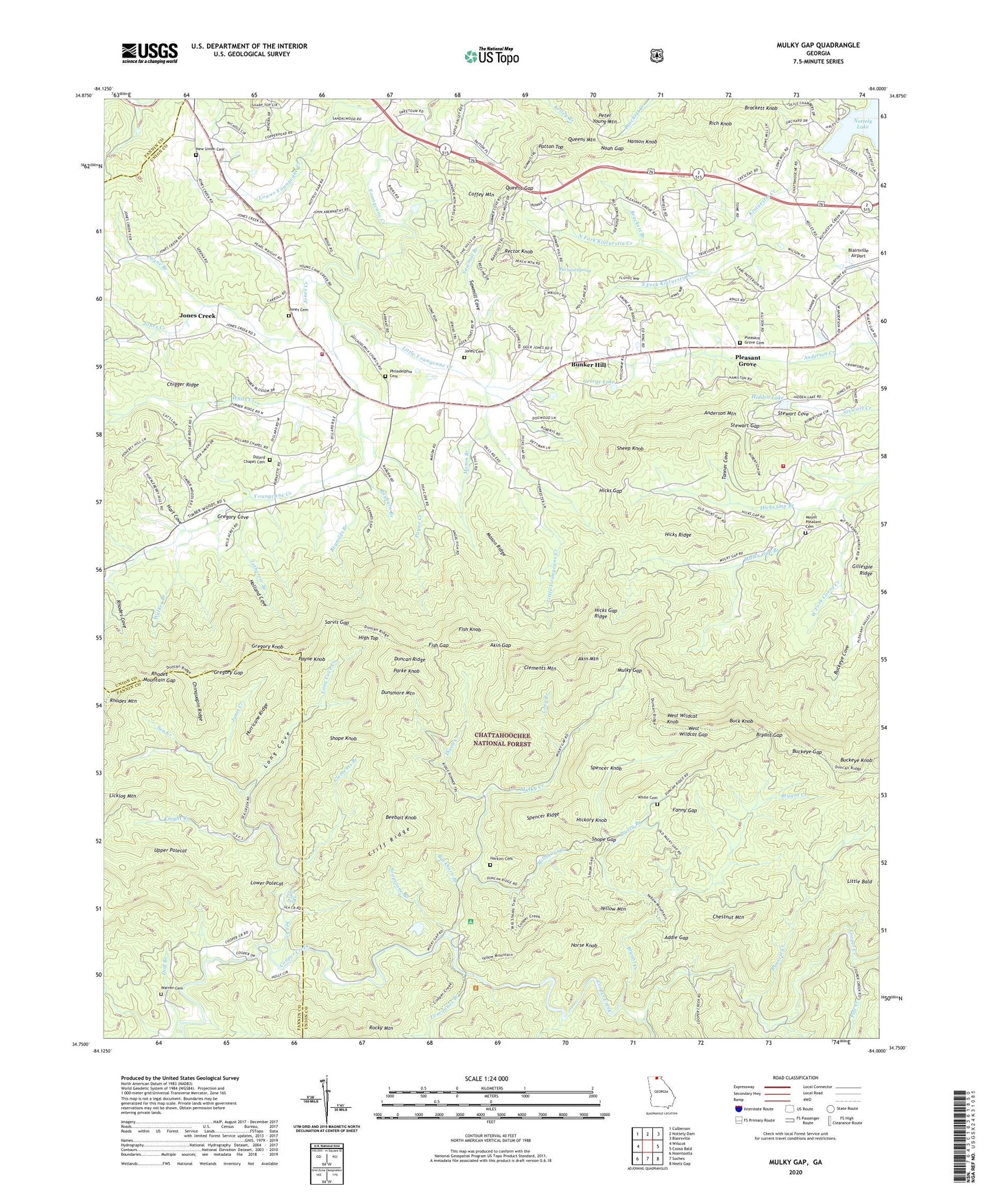
2024 topographic map quadrangle Mulky Gap in the state of Georgia. Scale: 1:24000. Based on the newly updated USGS 7.5' US Topo map series, this map is in the following counties: Union, Fannin. The map contains contour data, water features, and other items you are used to seeing on USGS maps, but also has updated roads and other features. This is the next generation of topographic maps. Printed on high-quality waterproof paper with UV fade-resistant inks.
Quads adjacent to this one:
West: Wilscot
Northwest: Culberson
North: Nottely Dam
Northeast: Blairsville
East: Coosa Bald
Southeast: Neels Gap
South: Suches
Southwest: Noontootla
This map covers the same area as the classic USGS quad with code o34084g1.
Contains the following named places: Addie Gap, Akin Gap, Akin Mountain, Anderson Mountain, Beebait Knob, Brackett Branch, Brackett Knob, Bryant Creek, Bryant Gap, Buck Knob, Buckeye Cove, Buckeye Gap, Buckhorn Branch, Bunker Hill, Bunker Hill Church, Bunker Hill School, Burnett Creek, Camp Ground School, Center Hill School, Chestnut Mountain, Chigger Ridge, Chinquapin Ridge, Clements Branch, Clements Mill, Clements Mountain, Cliff Ridge, Coffey Mountain, Confidence School, Cooper Creek Recreation Site, Cooper Creek Scenic Area, Coopers Creek Wildlife Management Area, Corinth School, Deep Cove Branch, Dillard Chapel, Dillard Chapel Cemetery, Dixon Creek, Duncan Ridge, Duncan Ridge Trail, Dunsmore Mountain, Fanny Gap, Fish Gap, Fish Knob, Flat Creek, Full Gospel Tabernacle, George Lake, George Lake Dam, Gillespie Ridge, Gregory Cove, Gregory Gap, Gregory Knob, Hanson Knob, Harkins Cemetery, Hart Cove, Helton Creek, Hemptown Gap, Hickory Knob, Hicks Gap, Hicks Gap Branch, Hicks Gap Ridge, Hicks Ridge, Hidden Lake, Hidden Lake Dam, High Top, Holland Cove, Horse Knob, Hurricane Ridge, Jones Cemetery, Jones Creek, Kiutuestia Creek, Knight Creek, Little Youngcane Creek, Long Branch, Long Cove, Long Cove Creek, Lower Polecat, Lower Youngcane Creek, Lows Mill, Mason Branch, Mason Ridge, Millshoal Creek, Mount Pleasant Cemetery, Mount Pleasant Church, Mount Pleasant School, Mulky Creek, Mulky Gap, Mulky Gap Branch, Mulky Gap Camping Area, Mulky Recreation Site, New Union Cemetery, New Union Church, New Union School, Noah Gap, North Fork Kiutuestia Creek, Parham Spring, Parke Knob, Patton Top, Payne Branch, Payne Creek, Payne Knob, Philadelphia Cemetery, Philadelphia Church, Pleasant Grove, Pleasant Grove Cemetery, Pleasant Grove Church, Pleasant Grove School, Pretty Branch, Queens Gap, Queens Mountain, Rayburn Branch, Rector Knob, Reynolds Branch, Rhodes Cove, Rhodes Mountain, Rhodes Mountain Gap, Rich Knob, Rogers, Rugby School, Sarvis Gap, Sawmill Branch, Sawmill Cove, Sea Creek, Sea Creek Falls, Sheep Knob, Shope Gap, Shope Knob, Smith Mill, Soapstone Branch, South Fork Kiutuestia Creek, Spencer Knob, Spencer Ridge, Spriggs Chapel School, Stewart Gap, Stillhouse Branch, Tanner Cove, Timber Ridge School, Tom Jones Branch, Totherow Branch, Union County Fire Department Station 2, Union County Fire Department Station 9, Upper Polecat, Victory Church, Walker Branch, Warren Cemetery, Watts Creek, West Wildcat Gap, West Wildcat Knob, White Cemetery, William Branch, Yellow Mountain, Young Cane School, Youngcane, Youngcane School