
MyTopo
New Home Georgia US Topo Map
Couldn't load pickup availability
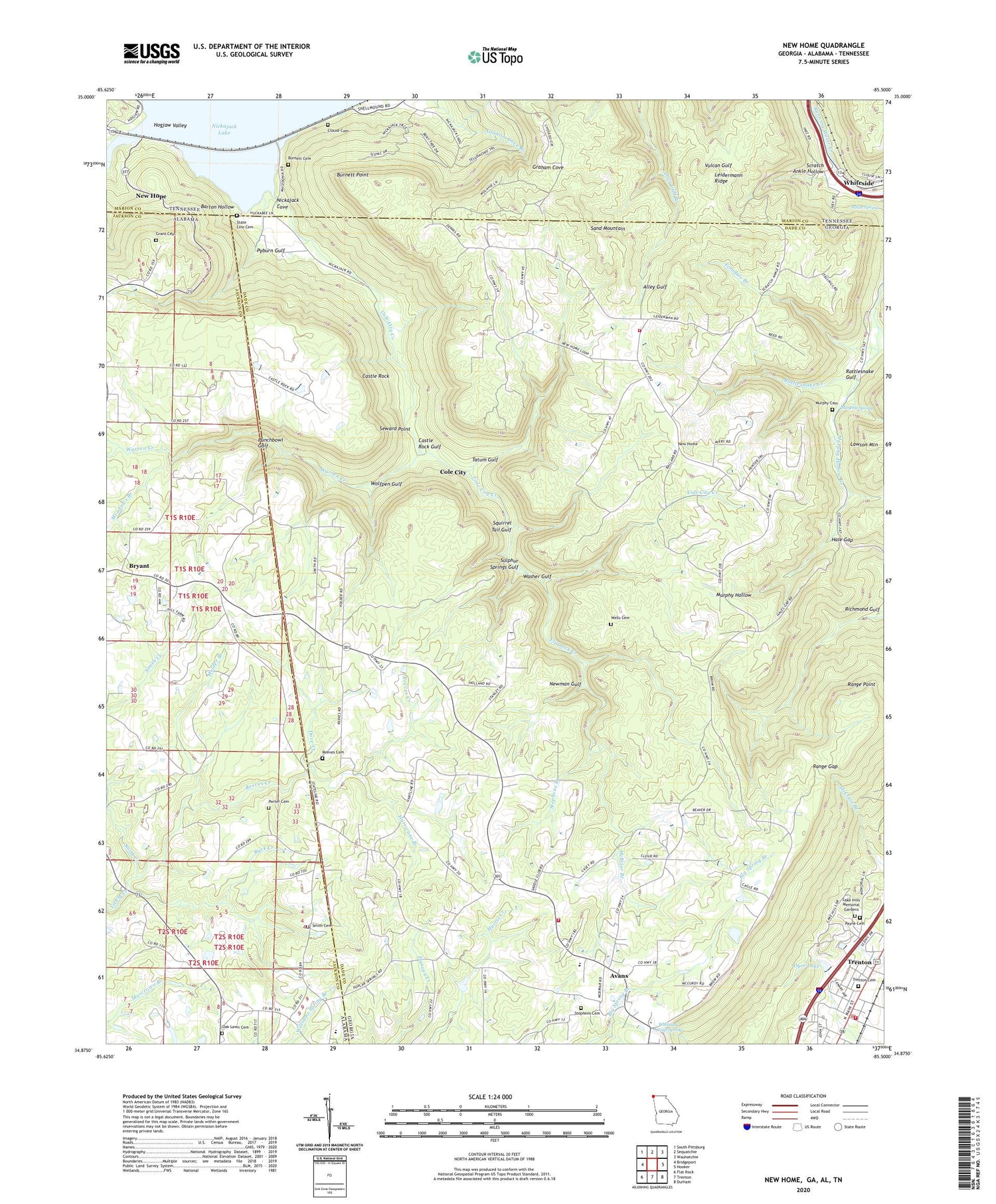
2024 topographic map quadrangle New Home in the states of Georgia, Alabama, Tennessee. Scale: 1:24000. Based on the newly updated USGS 7.5' US Topo map series, this map is in the following counties: Dade, Jackson, Marion. The map contains contour data, water features, and other items you are used to seeing on USGS maps, but also has updated roads and other features. This is the next generation of topographic maps. Printed on high-quality waterproof paper with UV fade-resistant inks.
Quads adjacent to this one:
West: Bridgeport
Northwest: South Pittsburg
North: Sequatchie
Northeast: Wauhatchie
East: Hooker
Southeast: Durham
South: Trenton
Southwest: Flat Rock
Contains the following named places: Avans, Avans Church, Bailey Mine, Barton Hollow, Browns Chapel, Bryant Church, Buck Creek, Burnett Cemetery, Burnett Point, Calvary Baptist Church, Castle Rock, Castle Rock Gulf, Castle Rock Mine, Clouse Cemetery, Cole City, Cole City Creek, Cole City Mine, Dade Mine, Davis Elementary School, Davis Volunteer Fire Department Station 7, Davis-Wells Mine, Dove Creek, Dyer Lake, Dyer Lake Dam, Ebenezer Church, Ferndale Branch, Ferndale Mine, Flatrock Creek, General Church, Getter Lake, Grant Cemetery, Green Mine, Hale Gap, Hill Poultry Farm, Hogjaw Creek, Holder Branch, Holland Mine, Hurricane Branch, Lake Hills Estates Dam, Lake Hills Memorial Gardens, Leidermann Ridge, Macedonia Church, Maple View Public Use Area, Mapleview Campsite, Mars Mine, McBriar Branch, Meadows Branch, Murphy Cemetery, Murphy Hollow School, Murphy Mine, Murphy Spring, New England Mine, New Home, New Home Church, New Home Community Center, New Home Fire Department, New South Mine, New Unity Church, Newman Gulf, Nickajack, Nickajack Cove, Oak Lawn Cemetery, Parker Mine, Pat Obrien Mine, Payne Cemetery, Poplar Springs Church, Poplar Springs School, Porter Cemetery, Punchbowl Gulf, Pyburn Gulf, Racoon Mine, Range Gap, Range Point, Rattlesnake Creek, Rattlesnake Gulf, Rattlesnake Mine, Reeves Cemetery, Reeves Creek, Richmond Gulf, Sand Mountain Division, Scealf School, Scratch Ankle Hollow, Seward Point, Shellmound, Shellmound Station, Smith Cemetery, Smith Creek, Squirrel Tail Gulf, State Line Cemetery, Stephens Branch, Stephens Cemetery, Sulphur Springs Gulf, Tatum Gulf, Tatum Gulf Mine, Trenton Cemetery, Trenton Fire Department, Trenton Police Department, Warren Creek, Washer Gulf, Wells Cemetery, White Spring, Whiteoak Baptist Church, Whiteoak Gap, Whiteoak Gap Spring, Whiteside School, Wolfpen Gulf, Woodlawn Baptist Church, ZIP Code: 30752


