MyTopo
Trenton Georgia US Topo Map
Couldn't load pickup availability
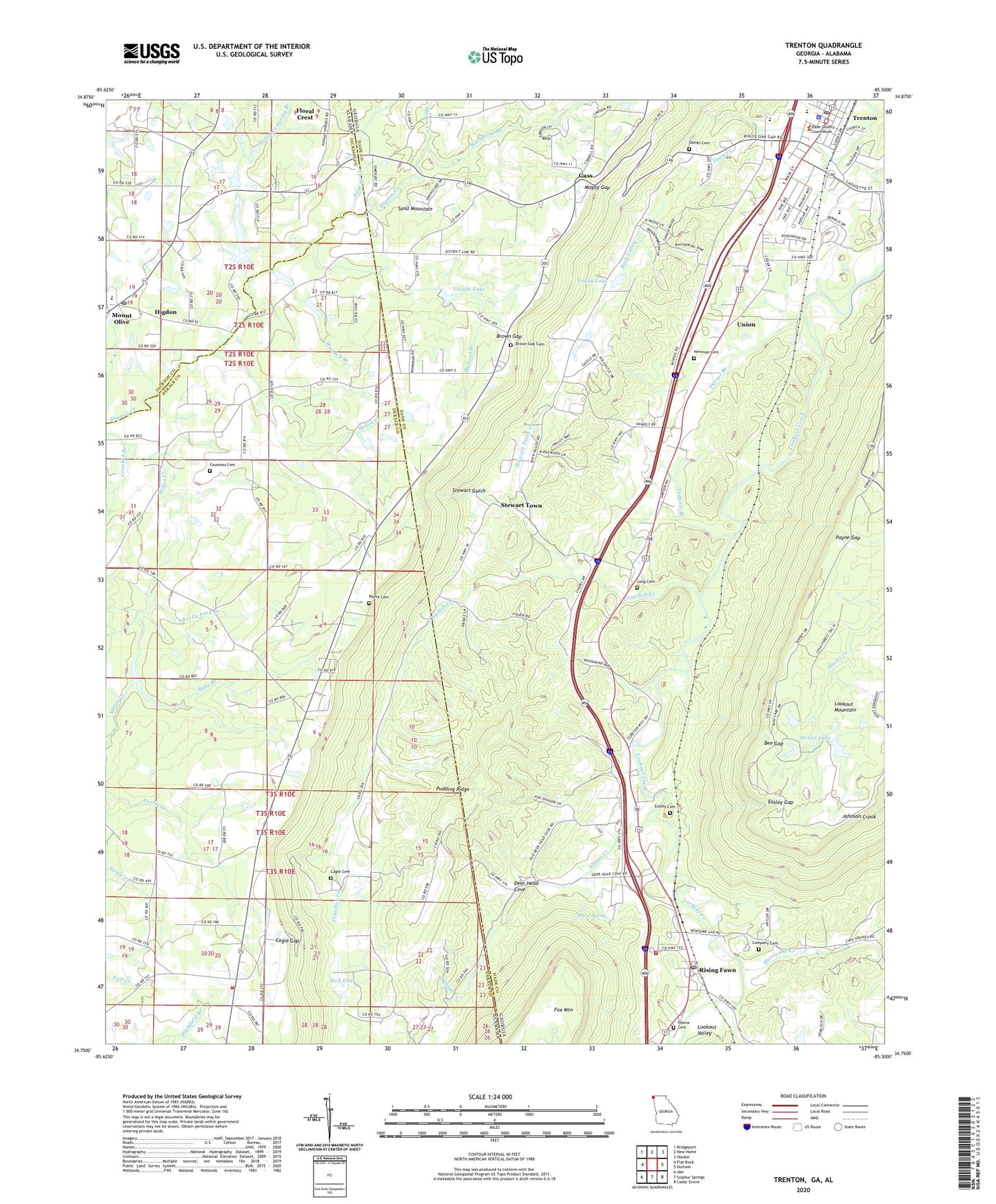
2024 topographic map quadrangle Trenton in the states of Georgia, Alabama. Scale: 1:24000. Based on the newly updated USGS 7.5' US Topo map series, this map is in the following counties: Dade, DeKalb, Jackson. The map contains contour data, water features, and other items you are used to seeing on USGS maps, but also has updated roads and other features. This is the next generation of topographic maps. Printed on high-quality waterproof paper with UV fade-resistant inks.
Quads adjacent to this one:
West: Flat Rock
Northwest: Bridgeport
North: New Home
Northeast: Hooker
East: Durham
Southeast: Cedar Grove
South: Sulphur Springs
Southwest: Ider
This map covers the same area as the classic USGS quad with code o34085g5.
Contains the following named places: Advent Church, Allison Creek, Austin Creek, Back Valley, Bee Gap, Beulah, Big Spring Branch, Brown Gap, Brown Gap Cemetery, Brown Gap Church, Brown Gap School, Bullard Branch, Byrds Chapel, Cagle Cemetery, Cagle Gap, Cartersville, Cartersville Volunteer Fire Department, Cedar Hill, Church of Christ, City of Trenton, Clearview Church, Company Cemetery, Countess Cemetery, Crawfish Creek, Crooked Branch, Dade County, Dade County Courthouse, Dade County Emergency Medical Station 5, Dade County High School, Dade County Jail, Dade County Sheriff's Office, Dade Elementary School, Dade Middle School, Dade Primary School, Daniel Cemetery, Deer Head Church, Deer Head Cove, Deer Head School, Duncan Creek, Easley Cemetery, Easley Gap, East Brow Church, Edgewood Missionary Baptist Church, Eliza, First Baptist Church of Trenton, Floral Crest, Forest Hill Church, Gass, Hanna Cemetery, Harris Chapel, Harris Creek, Haynes Chapel, Haynes Chapel Cemetery, Higdon, Higdon Post Office, Hurricane Creek, Life and Praise Temple, Long Cemetery, Magby Gap, McGee Lake, McGee Lake Dam, Moore Lake, Mount Olive, Mount Olive Church, New Testament Church, Newman Cemetery, North Sand Mountain High School, Northwest Georgia High School, Payne Gap, Pleasant Grove Church, Poplar Spring, Pudding Ridge, Rising Fawn, Rising Fawn Baptist Church, Rising Fawn Church, Rising Fawn Church of God, Rising Fawn Post Office, Rocky Ford Branch, Sally Branch, Sand Mountain Academy, Sand Mountain Church, Sandmont Bible Camp, Shiloh, Shiloh Church, Shiloh Creek, South Dade Fire Department, Stewart Gulch, Stewart Town, Stewart Town Creek, Tadpole Branch, Tatum, Trenton, Trenton Post Office, Trenton United Methodist Church, Turner Branch, Union, United Church of Christ, Vaught Lake, Vaught Lake Dam, Well Flat, White Oak Mine, Williams Spring Branch, Wooten Branch, Young Lake, Young Lake Dam, ZIP Code: 35979