MyTopo
Rome North Georgia US Topo Map
Couldn't load pickup availability
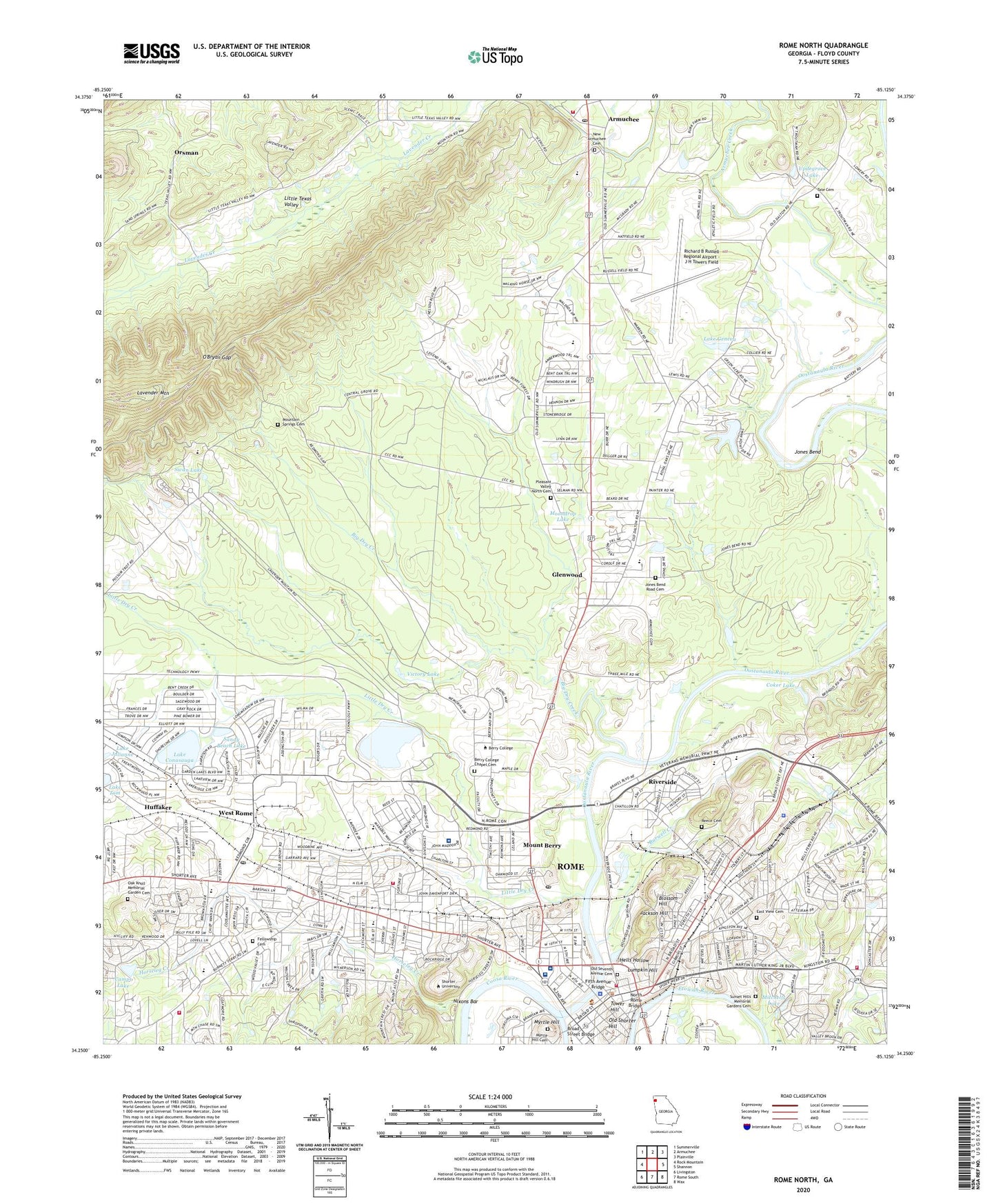
2024 topographic map quadrangle Rome North in the state of Georgia. Scale: 1:24000. Based on the newly updated USGS 7.5' US Topo map series, this map is in the following counties: Floyd. The map contains contour data, water features, and other items you are used to seeing on USGS maps, but also has updated roads and other features. This is the next generation of topographic maps. Printed on high-quality waterproof paper with UV fade-resistant inks.
Quads adjacent to this one:
West: Rock Mountain
Northwest: Summerville
North: Armuchee
Northeast: Plainville
East: Shannon
Southeast: Wax
South: Rome South
Southwest: Livingston
This map covers the same area as the classic USGS quad with code o34085c2.
Contains the following named places: Alto Park Elementary School, Alto Shopping Center, Armuchee Church, Armuchee Elementary School, Armuchee High School, Armuchee Park, Armuchee Post Office, Atteiram Heights, Barretts Mill, Barron Stadium, Berkshire Estates, Berry Academy, Berry College, Berry College Census Designated Place, Berry College Chapel, Berry College Chapel Cemetery, Berry College Wildlife Management Area and Refuge, Between the Rivers Historic District, Big Dry Creek, Blossom Hill, Broad Street Baptist Church, Broad Street Bridge, Brookwood, Burwell Creek, Calvary Baptist Church, Camps Lake, Carnegie Library, Central Church of Christ, Central Grove, Central Grove Methodist Church, Central Grove School, Central Primary School, Cherokee Acres, Chiaha, Chieftains, Chieftains Museum, Church of Christ, Church of God, City of Rome, Coker Lake, Coosa Country Club, Coosa Valley Fairgrounds, Darlington Lower School, DeSoto, DeSoto Homes, Division Street Park, Eagle Park, East Rome High School, East View Cemetery, Elliott Jaycee Field, Elm Street Elementary School, Emanuel Church, Etowah Park, Etowah River, Fair Oaks, Fellowship Baptist Church, Fellowship Cemetery, Fieldwood, Fifth Avenue Baptist Church, Fifth Avenue Bridge, Fifth Avenue Public School, First Baptist Church of Rome, First Christian Church, First Church of Christ Scientist, First Presbyterian Church, First United Methodist Church, Floyd Behavioral Health Center, Floyd County, Floyd County Courthouse, Floyd County Jail, Floyd County Sheriff's Office, Floyd Medical Center, Forrest Monument, Fort Jackson Reservoir, Gala Shopping Center, Garden Lakes, Garden Lakes Baptist Church, Garden Lakes Elementary School, Georgia State Patrol Troop A Post 38 Rome, Glenwood, Glenwood Primary School, Glenwood School, Grace Church, Green Acre, Green Acres Country Club, Harbin Clinic, Hells Hollow, Heritage Park, Hidden Valley, Hillcrest Baptist Church, Holsey Sinai Christian Methodist Episcopal Church, Homewood School, Horseleg Creek, Huffaker, Huffaker Road Baptist Church, Jackson Hill, Jones Bend, Jones Bend Road Cemetery, Jones Mill, Kingdom Hall of Jehovahs Witnesses, Lake Conasauga, Lake Conasauga Dam, Lake Geneva, Lake Tom, Lakemoore Heights, Lavender Mountain, Little Dry Creek, Livingston Library, Lower Avenue A Historic District, Lumpkin Hill, Main Elementary School, Maplewood, Maplewood Park, Martha Berry Museum and Art Gallery, Memorial Library, Metropolitan United Methodist Church, Mitchells Lake, Moondrop Lake, Mount Berry, Mount Berry Contract Postal Unit, Mountain Springs Cemetery, Mountain Springs Church, Myrtle Hill, Myrtle Hill Cemetery, New Armuchee Baptist Church, New Armuchee Cemetery, New Canaan Baptist Church, Nichols Mill, Nixons Bar, Norcross Chapel, North Broad Baptist Church, North Heights Elementary School, North Hills, North Rome, North Rome Bridge, North Rome Christian Learning Center, North Rome Church of God, North Rome School, North Rome United Methodist Church, Northside School, Northwest Georgia Regional Hospital, Oak Hill, Oak Knoll Memorial Garden Cemetery, O'Bryan Gap, Old Seventh Avenue Cemetery, Old Shorter Hill, Oostanaula River, Orsman, Orsman School, Perkins Island, Pleasant Valley Church, Pleasant Valley North Cemetery, Redmond Regional Medical Center, Reece Cemetery, Richard B Russell Regional Airport - J H Towers Field, Riverside, Riverside Park, Riverside School, Riverview Park, Roeph Sholom Synagogue, Rome, Rome - Floyd County Fire Department Station 4, Rome - Floyd County Fire Department Station 5, Rome - Floyd County Fire Department Station 6, Rome - Floyd County Fire Department Station 8, Rome Christian Academy, Rome City Hall, Rome Fire Department Station 1 Headquarters, Rome Freewill Church, Rome High School, Rome Middle School, Rome Police Department, Rome Post Office, Rome Transitional Academy, Saint Marys Roman Catholic Church, Saint Peters Episcopal Church, Sand Springs, Sandy Beach Lake, Sequoia Acres, Shorter Avenue Baptist Church, Shorter College, Shorter Industrial Park, Solid Rock Baptist Church, South Broad Street Historic District, State Mutual Stadium, Summerville Park, Sunset Acres, Sunset Hills Memorial Gardens Cemetery, Swan Lake, Tate Cemetery, Thankful Baptist Church, The Flat Woods, Tolbert Park, Tower Hill, Trinity United Methodist Church, Updegrove Lake, Upper Avenue A Historic District, Victory Lake, Victory Lake Dam, Village Shopping Center, Warren School, Wesley Chapel, West Central Elementary School, West End Baptist Church, West End Elementary School, West End Shopping Center, West Rome, West Rome Baptist Church, West Rome Drive-In, West Rome High School, West Rome Junior High School, West Rome Post Office, West Rome United Methodist Church, Westside Village Shopping Center, Westwood, Widow Fools Ferry, Wilkerson Road Baptist Church, WLAQ-AM (Rome), WRGA-AM (Rome), Wright School, WROM-AM (Rome), WTSH-AM (Rome), ZIP Code: 30149