
MyTopo
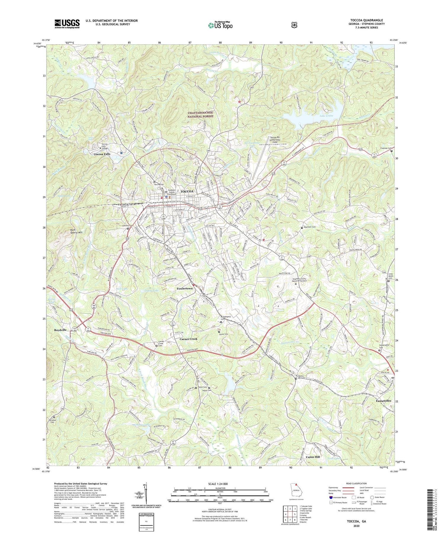
Toccoa Georgia US Topo Map
Couldn't load pickup availability
Also explore the Toccoa Forest Service Topo of this same quad for updated USFS data
2024 topographic map quadrangle Toccoa in the state of Georgia. Scale: 1:24000. Based on the newly updated USGS 7.5' US Topo map series, this map is in the following counties: Stephens. The map contains contour data, water features, and other items you are used to seeing on USGS maps, but also has updated roads and other features. This is the next generation of topographic maps. Printed on high-quality waterproof paper with UV fade-resistant inks.
Quads adjacent to this one:
West: Ayersville
Northwest: Tallulah Falls
Northeast: Holly Springs
East: Avalon
Southeast: Martin
South: Red Hill
Southwest: Lake Russell
This map covers the same area as the classic USGS quad with code o34083e3.
Contains the following named places: Alewine Park, Alliance Church, Autonomy Church, Barnes Lake, Big A Elementary School, Big A Shopping Center, Boydville, Broad River Dam Number 1, Calvary Church, Camp Toccoa, Carnes Creek, Carnes Creek Baptist Church, Carnes Creek Cemetery, Carnes Creek School, City of Toccoa, Collins Lake, Cross Roads Cemetery, Crossroads Church, Currahee Cemetery, Currahee Church, Davis Creek, Dead Man Branch, Denmans Creek, Eastanollee, Eastanollee Post Office, Ebenezer Cemetery, Ebenezer Church, First Baptist Church, First Presbyterian Church, First United Methodist Church, Fowlertown, Freeman Cemetery, Freeman Creek, Freewill Church, Friendship Baptist Church, Georgia State Patrol Troop B Post 7, Gospel Church, Hayes Cemetery, Hayes Crossing, Henderson Falls Park, Hill Street Baptist Church, Lake Louise, Lake Louise Dam, Lakeview Church, Le Tourneau Lake, Le Tourneau Lake Dam, Leo Park, Liberty Elementary School, Liberty Hill Cemetery, Liberty Hill Church, Little Toccoa Creek, Martin-Avalon Division, McMurry Lake, Merritt School, North Fork Broad River, North Fork Broad River Dam Number One, North Fork Broad River Structure 10 Dam, North Fork Broad River Structure Four Dam, North Fork Broad River Structure Three Dam, North Fork Broad River Structure Two Dam, Philadelphia Baptist Church, Philadelphia Cemetery, Pine Grove Church, Rock Quarry Church, Rock Quarry Mountain, Saint James United Methodist Church, Shiloh Church, Smith Lake, Steel Lake, Stephens County, Stephens County Courthouse, Stephens County Crossroads Success Academy, Stephens County Fire Department Station 1, Stephens County Fire Department Station 2, Stephens County Fire Department Station 6, Stephens County High School, Stephens County Hospital, Stephens County Memorial Gardens, Stephens County Middle School, Stephens County Sheriff's Office, Stonecupher Cemetery, Stonecypher Lake, Stowe Cemetery, Taccoa Fire Department Station 11, Taylor Cemetery, Toccoa, Toccoa Cemetery, Toccoa City Hall, Toccoa Creek Church, Toccoa Division, Toccoa Elementary School, Toccoa Falls, Toccoa Falls College, Toccoa Falls Police Department, Toccoa Fire Baptized Holiness Church of God, Toccoa Fire Department Station 10, Toccoa High School, Toccoa Post Office, Toccoa Reservoir, Toccoa RG Letourneau Field, Toccoa Water Reservoir, Toccoa Water Reservoir Dam, Trinity Christian Methodist Episcopal Church, Twin Lakes, Union Hill, Wards Pond, Welcome Church, Whitman Street High School, WLET Radio Tower, WLET-AM (Toccoa), WNEG Radio Tower, WNEG-AM (Toccoa), WNEG-TV (Toccoa), WRAF-FM (Toccoa Falls), Zebuion Church, Zebulon Cemetery, ZIP Codes: 30538, 30577


