MyTopo
Brooks Georgia US Topo Map
Couldn't load pickup availability
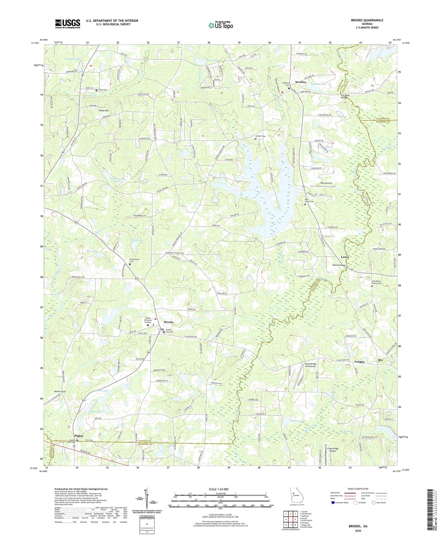
2024 topographic map quadrangle Brooks in the state of Georgia. Scale: 1:24000. Based on the newly updated USGS 7.5' US Topo map series, this map is in the following counties: Fayette, Spalding, Clayton, Coweta. The map contains contour data, water features, and other items you are used to seeing on USGS maps, but also has updated roads and other features. This is the next generation of topographic maps. Printed on high-quality waterproof paper with UV fade-resistant inks.
Quads adjacent to this one:
West: Senoia
Northwest: Tyrone
North: Fayetteville
Northeast: Hampton
East: Griffin North
Southeast: Griffin South
South: Hollonville
Southwest: Haralson
This map covers the same area as the classic USGS quad with code o33084c4.
Contains the following named places: Antioch Baptist Church, Antioch Cemetery, Antioch Creek, Bagwell Bridge, Bakersfield Farms, Bass Lake, Bear Creek, Bear Creek Landing, Brook Bridge Aerodrome, Brooks, Brooks Baptist Church, Brooks City Cemetery, Brooks City Hall, Brooks Division, Brooks Elementary School, Brooks Memorial Gardens, Brooks Post Office, Broom Hall, Burch Lake, Busbins Store, Cambridge Estates, Cedar Ridge Airport, Clover Lake, Clover Lake Dam, County Line Cemetery, County Line Christian Church, Cut Bank Bridge, Digbey, Digbey Church, Dorset Bridge, Dungan Lake, Dungan Lake Dam, Fayette County Fire and Emergency Services Station 5, Fayette County Fire and Emergency Services Station 6, Fayette County Fire and Emergency Services Station 7, Friendship, Friendship Church, Gantt Acres, Goza Dam, Goza Lake, Graves Lake, Graves Lake Dam, Gypsy Woods, Haddock Creek, Heads Creek, Hogg Dam, Hogg Lake, Horton Creek, Jebco Peoperties Lake Dam, Jebco Properties Lake, John Bates Family Cemetery, Jones Cemetery, Jones Hill, Jones Hill Estates, Kelley Lake, Kelley Lake Dam, Kenley Field, Lighthouse Church, Longino School, Lowry, Mallory Lake, Mallory Lake Dam, Mays Chapel, Morgans Mill, Mount Springs School, Mud Bridge, New Salem Church, Oakley Dam, Oakley Lake, Padgett Lake, Padgett Lake Dam, Pine Grove Baptist Church, Pine Grove Cemetery, Pine Grove Church, Porters Ridge, Reaves Bridge, Rio, Rising Star Church, Rust Airstrip, Scarbrough Lake, Scarbrough Lake Dam, Shoal Creek, Stubbs Plantation, The Meadows, Town of Brooks, Town of Woolsey, Valdo, Vaughn, Vaughn Church, Vaughn Division, White Water Church, Whitewater Cemetery, Wildcat Creek, Woolsey, Woolsey Baptist Church, Woolsey Cemetery, Woolsey Creek, Woolsey Creek Plantation, Woolsey Woods, Wyyatt-Grey Lake Dam, ZIP Code: 30205