MyTopo
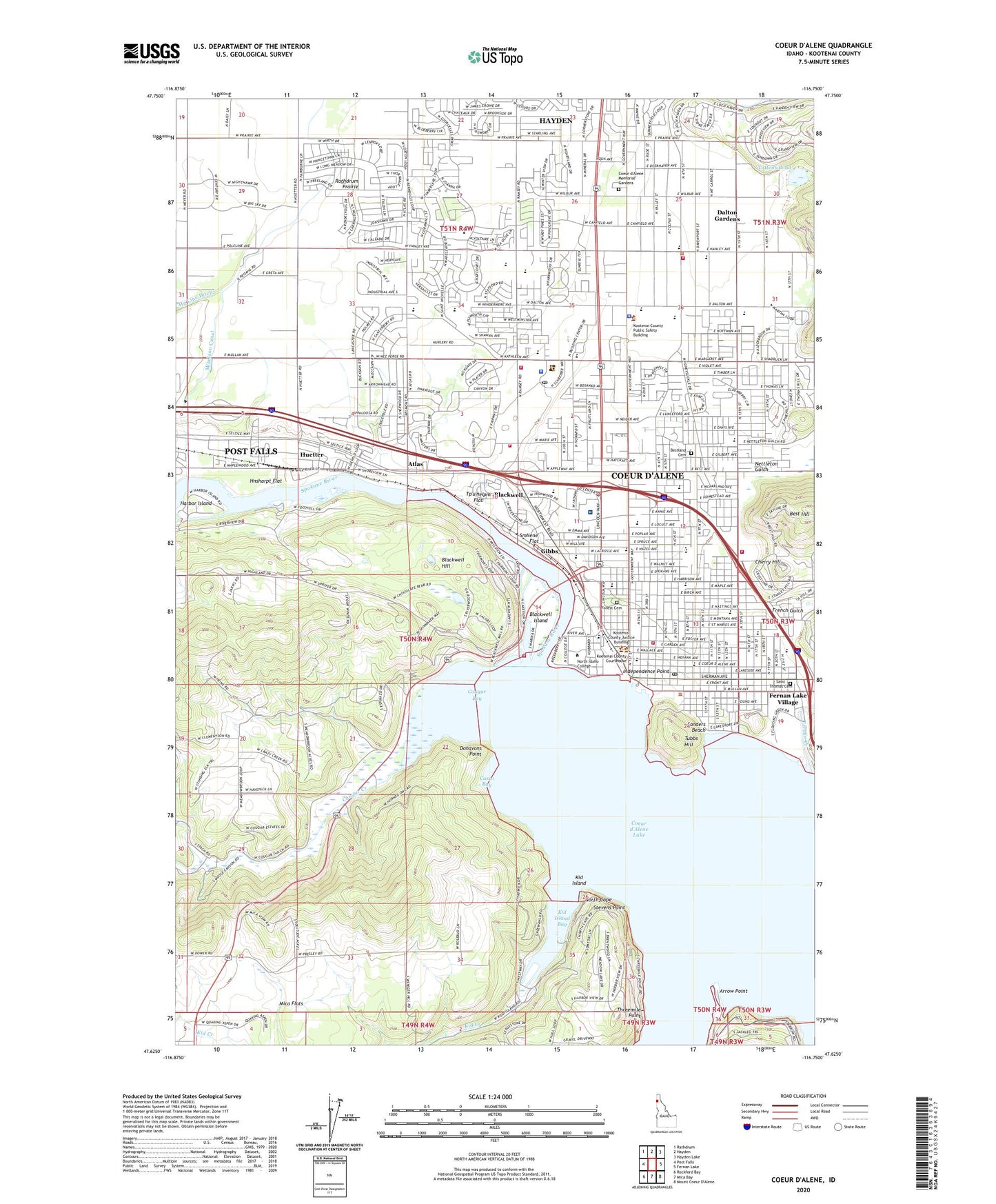
Coeur D'Alene Idaho US Topo Map
Couldn't load pickup availability
Also explore the Coeur D'Alene Forest Service Topo of this same quad for updated USFS data
2024 topographic map quadrangle Coeur D'Alene in the state of Idaho. Scale: 1:24000. Based on the newly updated USGS 7.5' US Topo map series, this map is in the following counties: Kootenai. The map contains contour data, water features, and other items you are used to seeing on USGS maps, but also has updated roads and other features. This is the next generation of topographic maps. Printed on high-quality waterproof paper with UV fade-resistant inks.
Quads adjacent to this one:
West: Post Falls
Northwest: Rathdrum
North: Hayden
Northeast: Hayden Lake
East: Fernan Lake
South: Mica Bay
Southwest: Rockford Bay
This map covers the same area as the classic USGS quad with code o47116f7.
Contains the following named places: Arrow Point, Atlas, Bestland Cemetery, Blackwell, Blackwell Hill, Blackwell Island, Blackwell Slough, Borah Elementary School, Brooks Seaplane Base, Bryan Elementary School, Bureau of Land Management Coeur d'Alene District, Bureau of Land Management Coeur d'Alene Field Office, Canfield Middle School, Casco Bay, Charlottes Webb, Cherry Hill, Christian Center School, City of Coeur d'Alene, City of Dalton Gardens, City of Huetter, Coeur D Alene Carrier Annex Post Office, Coeur d'Alene, Coeur d'Alene Christian School, Coeur d'Alene Division, Coeur d'Alene Fire Department Station 1, Coeur d'Alene Fire Department Station 2, Coeur d'Alene Fire Department Station 3, Coeur d'Alene High School, Coeur D'Alene Mall, Coeur d'Alene Memorial Gardens, Coeur d'Alene Police Department, Coeur d'Alene Post Office, Coeur d'Alene Pre-School Center, Coeur d'Alene Public Golf Course, Coeur D'Alene Resort Heliport, Cougar Bay, Cougar Creek, Dalton Elementary School, Dalton Gardens, Discovery, Donavons Point, Farmers Union, Fernan Creek, Forest Cemetery, Gibbs, Harbor Island, Harding Elementary School, Hnsharpt Flat, Huetter, Huetter Rest Areas, Independence Point, KCDA-FM (Coeur D'Alene), KETB-FM (Coeur D'Alene), Kid Creek, Kid Island, Kid Island Bay, Kootenai County Fire and Rescue Station 4, Kootenai County Fire and Rescue Station 5, Kootenai County Fire and Rescue Station 7, Kootenai County Sheriff's Office, Kootenai Medical Center, Kootenai Medical Center Heliport, Lake City Junior Academy, Lakes Middle School, Mae McEuen Playfield, Memorial Field, Mica Flats, Midtown Shopping Center, Mikelson Canal, Nettleton Gulch, North Cape, North Idaho Cancer Treatment Center, North Idaho College, North Idaho Day Surgery and Laser Center, North Idaho Immediate Care Center, Northview Plaza, Olaf Bustad School, Pine Crest Hospital, Project CDA High School, Ramsey Elementary School, Ramsey Magnet School of Science, Saint Thomas Cemetery, Sanders Beach, Silver Lake Mall, Smllene' Flat, Sorensen Magnet School of the Arts and Humanities, Stepping Stones Learning Center, Stevens Point, Threemile Point, Tottens Pond, Tp'u'nelpm Flat, Tubbs Hill, Winton Elementary School, ZIP Code: 83815