MyTopo
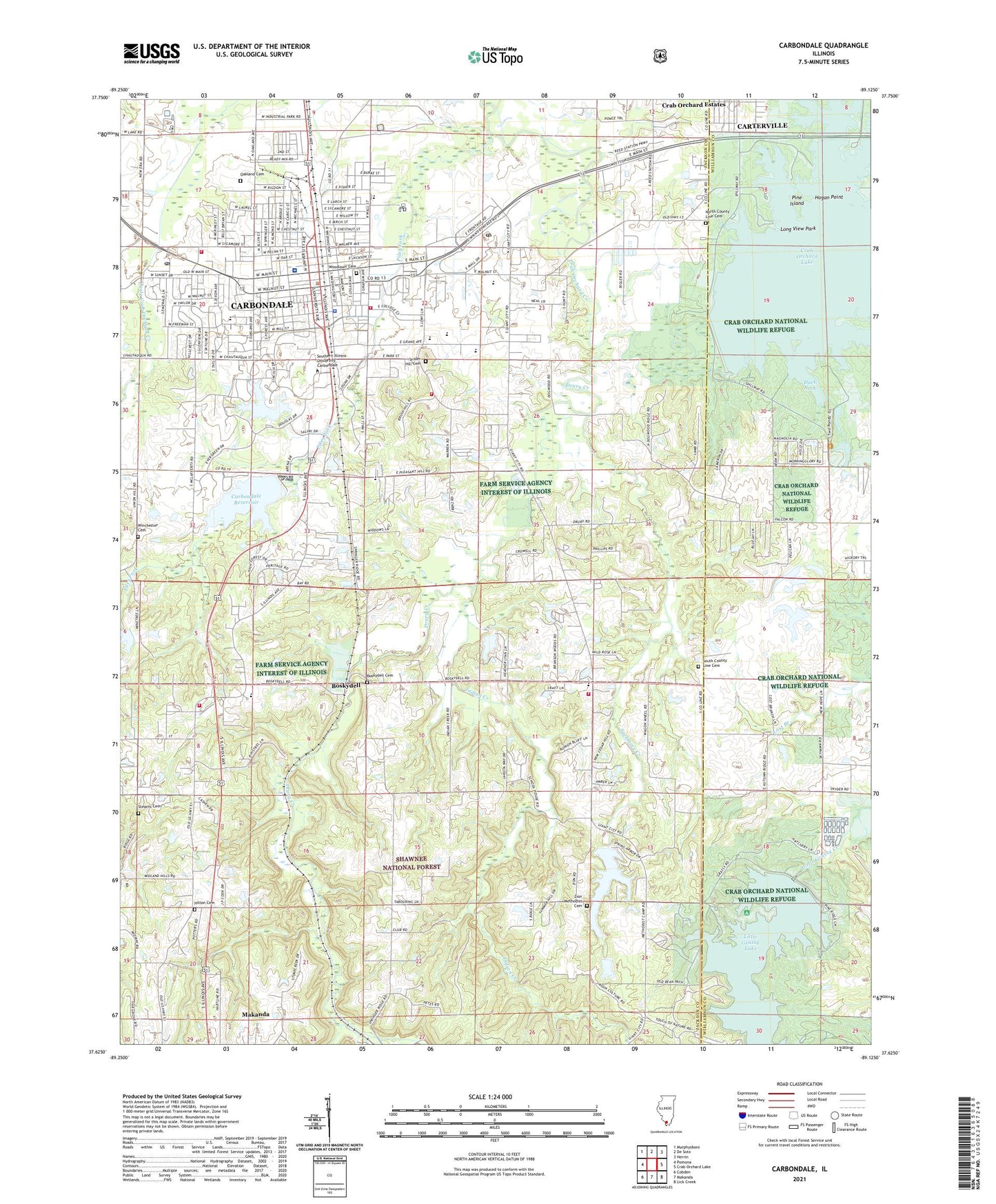
Carbondale Illinois US Topo Map
Couldn't load pickup availability
Also explore the Carbondale Forest Service Topo of this same quad for updated USFS data
2024 topographic map quadrangle Carbondale in the state of Illinois. Scale: 1:24000. Based on the newly updated USGS 7.5' US Topo map series, this map is in the following counties: Jackson, Williamson. The map contains contour data, water features, and other items you are used to seeing on USGS maps, but also has updated roads and other features. This is the next generation of topographic maps. Printed on high-quality waterproof paper with UV fade-resistant inks.
Quads adjacent to this one:
West: Pomona
Northwest: Murphysboro
North: De Soto
Northeast: Herrin
East: Crab Orchard Lake
Southeast: Lick Creek
South: Makanda
Southwest: Cobden
This map covers the same area as the classic USGS quad with code o37089f2.
Contains the following named places: Antioch Church, Attucks Park, Boskydell, Boskydell Cemetery, Brehm Preparatory School, Brierpath School, Camp Carew, Campus Lake, Campus Lake Dam, Carbondale, Carbondale City Hall, Carbondale Community High School Central Campus, Carbondale Community High School East Campus, Carbondale Fire Department Station 1, Carbondale Fire Department Station 2, Carbondale Police Department, Carbondale Post Office, Carbondale Public Library, Carbondale Reservoir, Carbondale Reservoir Dam, Carbondale Township Fire Department, Cedar Point Camp, City of Carbondale, Covered Bridge School, Crab Orchard Dam, Crab Orchard Estates, Crowell School, Doug Lee Park, Downtown Carbondale Post Office, Drury Christian Church, Drury Creek, Duck Neck, Eastgate Shopping Center, Evergreen Park, Evergreen Terrace, First Baptist Church, First United Methodist Church, Freewill Church, Giant City Elementary School, Hastings School, Hilton Cemetery, Hogan Point, Holden Hospital, Indian Creek, Jackson County Ambulance Service, Lakeland Baptist Church, Lakeland Elementary School, Lenus Turley Park, Lewis Elementary School, Lincoln Middle School, Little Grassy Dam, Little Grassy Fish Hatchery, Little Grassy Lake, Long View Park, Makanda Township Volunteer Fire Department Station 1, Makanda Township Volunteer Fire Department Station 2, Marberry Arboretum, Memorial Hospital of Carbondale, Memorial Hospital of Carbondale Heliport, New Hope Church, New Hope School, North County Line Cemetery, North County Line Church, North School, Oakdale Park, Oakland Cemetery, Oakland Field, Parrish Park, Piles Fork, Pine Island, Pine Ridge Camp, Pleasant Hill School, Pomona School, Prairie Creek, Renfro Park, Rock Spring School, Snider Hill Cemetery, South County Line Cemetery, South County Line Christian Church, Southern Hills, Southern Illinois University, Southern Illinois University Carbondale, Spring Arbor Lake, Springmore School, Stearns Cemetery, Stone School, Sycamore Creek, Sycamore Creek Dam, Tatum Heights Park, Thomas Elementary School, Township of Carbondale, Township of Makanda, Unity Point Elementary School, University Mall Shopping Center, Wagner School, West Walnut Street Historic District, Winchester Cemetery, Winkler Elementary School, Woodlawn Cemetery, WSIU-FM (Carbondale), Zion Church, Zion Methodist Cemetery, Zion School, ZIP Codes: 62901, 62958