MyTopo
Kankakee Illinois US Topo Map
Couldn't load pickup availability
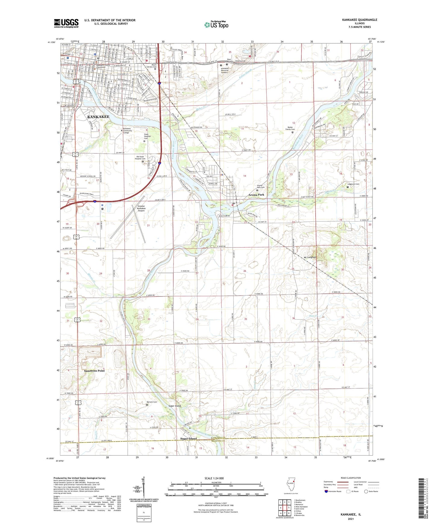
2024 topographic map quadrangle Kankakee in the state of Illinois. Scale: 1:24000. Based on the newly updated USGS 7.5' US Topo map series, this map is in the following counties: Kankakee, Iroquois. The map contains contour data, water features, and other items you are used to seeing on USGS maps, but also has updated roads and other features. This is the next generation of topographic maps. Printed on high-quality waterproof paper with UV fade-resistant inks.
Quads adjacent to this one:
West: West Kankakee
Northwest: Bourbonnais
North: Bradley
Northeast: Momence
East: Saint Anne
Southeast: Beaverville
Southwest: Clifton
This map covers the same area as the classic USGS quad with code o41087a7.
Contains the following named places: Amita Health Saint Marys Hospital, Annunciation Greek Orthodox Church, Aroma Park, Aroma Park Cemetery, Aroma Park Church of the Nazarene, Aroma Park Police Department, Aroma Park Post Office, Aroma Park Primary School, Aroma Park United Methodist Church, Aroma Township Fire Protection District Station 1, Asbury United Methodist Church, Baker Creek, Baker School, Barnett Cemetery, Beckman Park, Beebe Family Cemetery, Beebetown School, Bnai Israel Cemetery, Brainard Creek, Butler View Dairy, Case School, Central Christian Church, Church of God, City of Kankakee, Cobb Park, Deer Creek, Edison Primary School, Exline Slough, First Baptist Church, First Church of Christ Scientist, First Church of God, First Church of the Nazarene, First Presbyterian Church, Gar Creek, Gooseberry Island Nature Preserve, Grace Baptist Church, Grace School, Greater Kankakee Airport, Immanuel Baptist Church, Iroquois River, Iroquois Woods Nature Preserve, Jefferson Public School, Jobbers Park, Kankakee, Kankakee Community College, Kankakee Country Club, Kankakee County Courthouse, Kankakee County Detention Center, Kankakee County Fairground, Kankakee County Sheriff's Office, Kankakee Elks Country Club, Kankakee Fire Department Station 3, Kankakee Fire Department Station 4, Kankakee Fire Department Training and Reserve Apparatus Station 2, Kankakee Junior High School, Kankakee Memorial Gardens, Kankakee Police Department, Kankakee Police Department River Patrol, Kankakee Post Office, Kankakee Public Library, Kankakee Township Fire Protection District Station 1, Kankakee Township Fire Protection District Station 2, King Middle Grade School, Lafayette Primary School, Leggtown Cemetery, Leggtown School, Lincoln School, Mark Twain Primary School, Marycrest Shopping Center, Mellen School, Mills School, Minnie Creek, Mount Calvary Cemetery, Mount Langham, Mount Langham School, Nazarene Youth Camp, Old State Hospital Cemetery, Pallissard School, Pierson Park, River Road Park, Riverview Historic District, Saint Joseph Seminary, Saint Marys Hospital Heliport, Saint Marys Roman Catholic Church, Saint Patricks Roman Catholic Church, Saint Patricks School, Saint Pauls Episcopal Church, Saint Pauls Lutheran Church, Saint Pauls School, Saint Rosa of Lima Roman Catholic School, Saint Rose Roman Catholic Church, Saint Teresa Roman Catholic Church, Saint Teresas School, Sammons Point, Scott School, Seedorf School, Shapiro Developmental Center, Shiloh Baptist Church, Snow Park, Spring Creek, State Hospital Cemetery, Steuben Elementary School, Strasma Park, Streeterville School, Sugar Island, Sugar Island School, Temple Bnai Israel, Township of Aroma, Township of Kankakee, Trail Creek, Trinity Lutheran Church, Trinity United Methodist Church, Village of Aroma Park, Village of Sammons Point, Washington School, WKVF-FM (Kankakee), ZIP Code: 60910