MyTopo
Mascoutah Illinois US Topo Map
Couldn't load pickup availability
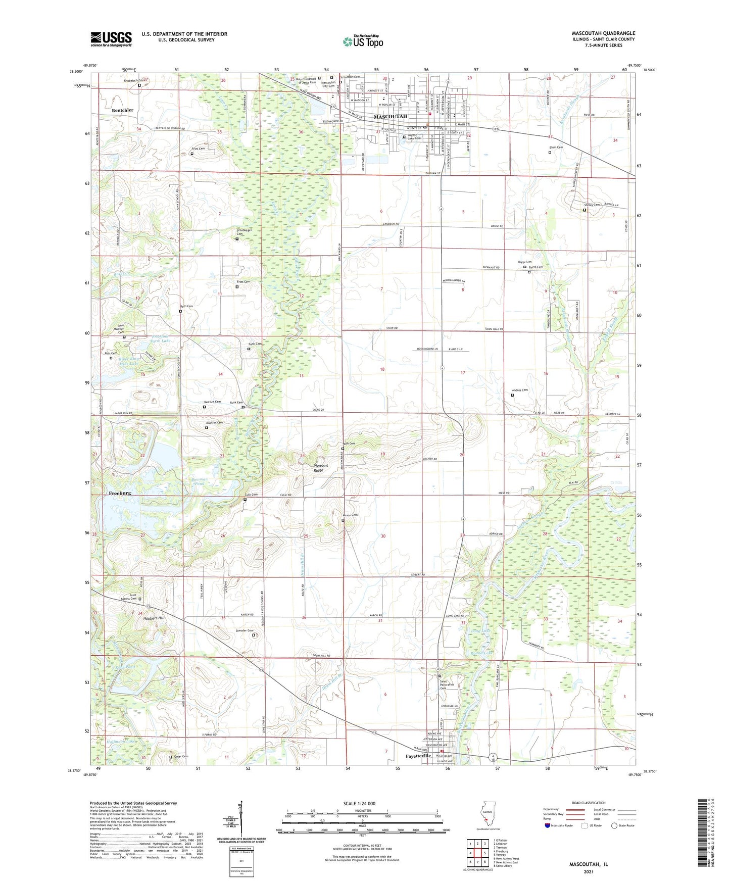
2024 topographic map quadrangle Mascoutah in the state of Illinois. Scale: 1:24000. Based on the newly updated USGS 7.5' US Topo map series, this map is in the following counties: St. Clair. The map contains contour data, water features, and other items you are used to seeing on USGS maps, but also has updated roads and other features. This is the next generation of topographic maps. Printed on high-quality waterproof paper with UV fade-resistant inks.
Quads adjacent to this one:
West: Freeburg
Northwest: O'Fallon
North: Lebanon
Northeast: Trenton
East: Venedy
Southeast: Saint Libory
South: New Athens East
Southwest: New Athens West
This map covers the same area as the classic USGS quad with code o38089d7.
Contains the following named places: American Legion Freedom Park, Andres Cemetery, Barth Cemetery, Batdorf School, Bethel United Methodist Church, Blum Cemetery, Bopp Cemetery, Bottom Lake, Bowman Pond, Culli Cemetery, Dressler Cemetery, Drum Hill School, Engelmann School, Espenschied Chapel, Fayetteville, Fayetteville Community Park, Fayetteville Volunteer Fire Department, First Assembly Church, Freedom Farm Lake, Freedom Farm Lake Dam, Fries Cemetery, Funk Cemetery, Funk School, Geier Cemetery, Halfmoon Lake, Haubers Hill, Hazel Creek, Heberers Branch, Hog River, Holy Childhood of Jesus Catholic Church, Holy Childhood of Jesus Catholic School, Holy Childhood of Jesus Cemetery, Jacks Run, Jackson Slough, Jefferson School, John Mueller Cemetery, Knobeloch Cemetery, Koch Pond, Leu Civil Center, Lincoln Lake Cemetery, Long Lake, Loop Creek, Maple Park, Mascoutah, Mascoutah Church of Christ, Mascoutah City Cemetery, Mascoutah City Hall, Mascoutah Community High School, Mascoutah Department of Public Safety EMS, Mascoutah Fire Department, Mascoutah Junior High School, Mascoutah Police Department, Mascoutah Post Office, Mascoutah School, Mason Cemetery, Mueller Cemetery, Peabody-River King Number 1 Mine Heliport, Pleasant Ridge, Pleasant Ridge School, Rayhill Slough, Reinhardt Slough, Rentchler, Rentchler Census Designated Place, River King Mine Lake, River King Mine Number One, Ross Cemetery, Roth Cemetery, Round Lake, Saint Agatha Cemetery, Saint John United Church of Christ, Saint Pancratius Cemetery, Saint Pancratius Church, Scheve Park, Schneblin Cemetery, Schubkegel Cemetery, Sheley Cemetery, Township of Engelmann, Township of Freeburg, Trinity Church, Village of Fayetteville, Woodland Grange, Zion Lutheran Church, Zion Lutheran School, ZIP Code: 62258