MyTopo
Chesterton Indiana US Topo Map
Couldn't load pickup availability
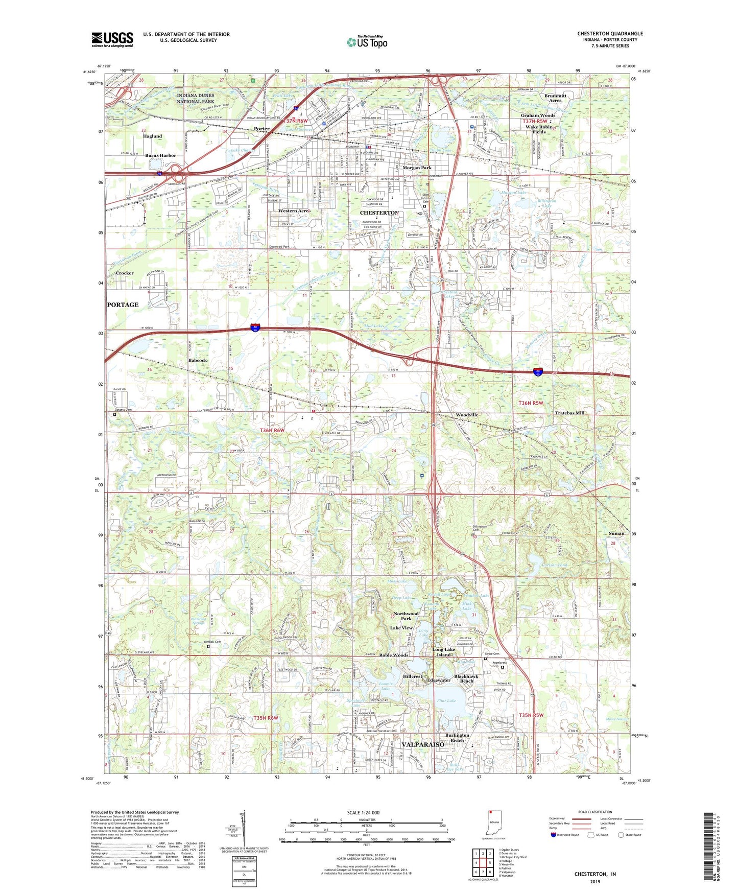
2022 topographic map quadrangle Chesterton in the state of Indiana. Scale: 1:24000. Based on the newly updated USGS 7.5' US Topo map series, this map is in the following counties: Porter. The map contains contour data, water features, and other items you are used to seeing on USGS maps, but also has updated roads and other features. This is the next generation of topographic maps. Printed on high-quality waterproof paper with UV fade-resistant inks.
Quads adjacent to this one:
West: Portage
Northwest: Ogden Dunes
North: Dune Acres
Northeast: Michigan City West
East: Westville
Southeast: Wanatah
South: Valparaiso
Southwest: Palmer
This map covers the same area as the classic USGS quad with code o41087e1.
Contains the following named places: Angelcrest Cemetery, Augsburg Church, Babcock, Bailly Elementary School, Bailly Homestead, Bicentennial Park, Billington Lake, Blackhawk Beach, Brummitt Acres, Brummitt Elementary School, Burlington Beach, Butternut Springs, Butternut Springs Girl Scout Camp, Camp Farr, Camp Lawrence, Canada Lake, Carlson Pond, Chesterton, Chesterton Cemetery, Chesterton Community Church, Chesterton Fire Department, Chesterton Park, Chesterton Police Department, Chesterton Post Office, Chesterton Senior High School, Chestnut Lakes, Chubb Lake, Coffee Creek, Coffee Creek Park, Cooks Corner Elementary School, Crocker, Crocker Bible Baptist Church, Damon Run, Deep Lake, Dillingham Cemetery, Dogwood Park, Edgewater, Faith Memorial Lutheran Church, First Baptist Church, Flint Lake, Flint Lake Elementary School, Forest Oaks, Gossett Cemetery, Graham Woods, Gustafson Ditch, Haglund, Hawthorne Park, Hillcrest, Indian Springs Park, Johnson Ditch, Kimball Cemetery, Kinne Cemetery, Lake Charles, Lake Florence, Lake View, Lakewood Park, Liberty Bible Church, Liberty Elementary School, Liberty Farm Mobile Home Park, Liberty Intermediate School, Liberty Township Volunteer Fire Department, Long Lake, Long Lake Island, Loomis Lake, Loomis Lake Dam, Meadowbrook, Mink Lake, Mink Lake Golf Course, Moraine Nature Preserve, Morgan Lake, Morgan Park, Moss Lake, Mud Lake, New Life Wesleyan Church, Newton Yost Elementary School, Northwood Park, Peterson Ditch, Pines Ski Area, Pope-O'Conner Ditch, Porter, Porter Assembly of God Church, Porter County, Porter Emergency Medical Services Station 1, Porter Fire Department, Porter Police Department, Pratt Lake, Rainbow Mobile Home Park, Roble Woods, Rodgers-Lakewood Park, Round Lake, Saint Francis Episcopal Church, Saint Patricks Cemetery, Saint Patricks Church, Saint Patricks School, Saint Paul Lutheran Church, Sand Creek, Sand Creek Country Club, Shooter Ditch, Special Education Learning Facility, Spectacle Lake, Suman, Swanson Lamporte Ditch, The Church of Jesus Christ of Latter Day Saints, Thomas School, Thomds Centennial Park, Town of Chesterton, Township of Liberty, Traekabas Mill Dam, Tratebas Mill, United Pentecostal Church, Valparaiso Country Club, Wake Robin Fields, Wauhob Lake, Westchester Intermediate School, Westchester Public Library, Western Acres, Whispering Sands Mobile Home Court, Woodville, ZIP Code: 46304