MyTopo
Maywood Indiana US Topo Map
Couldn't load pickup availability
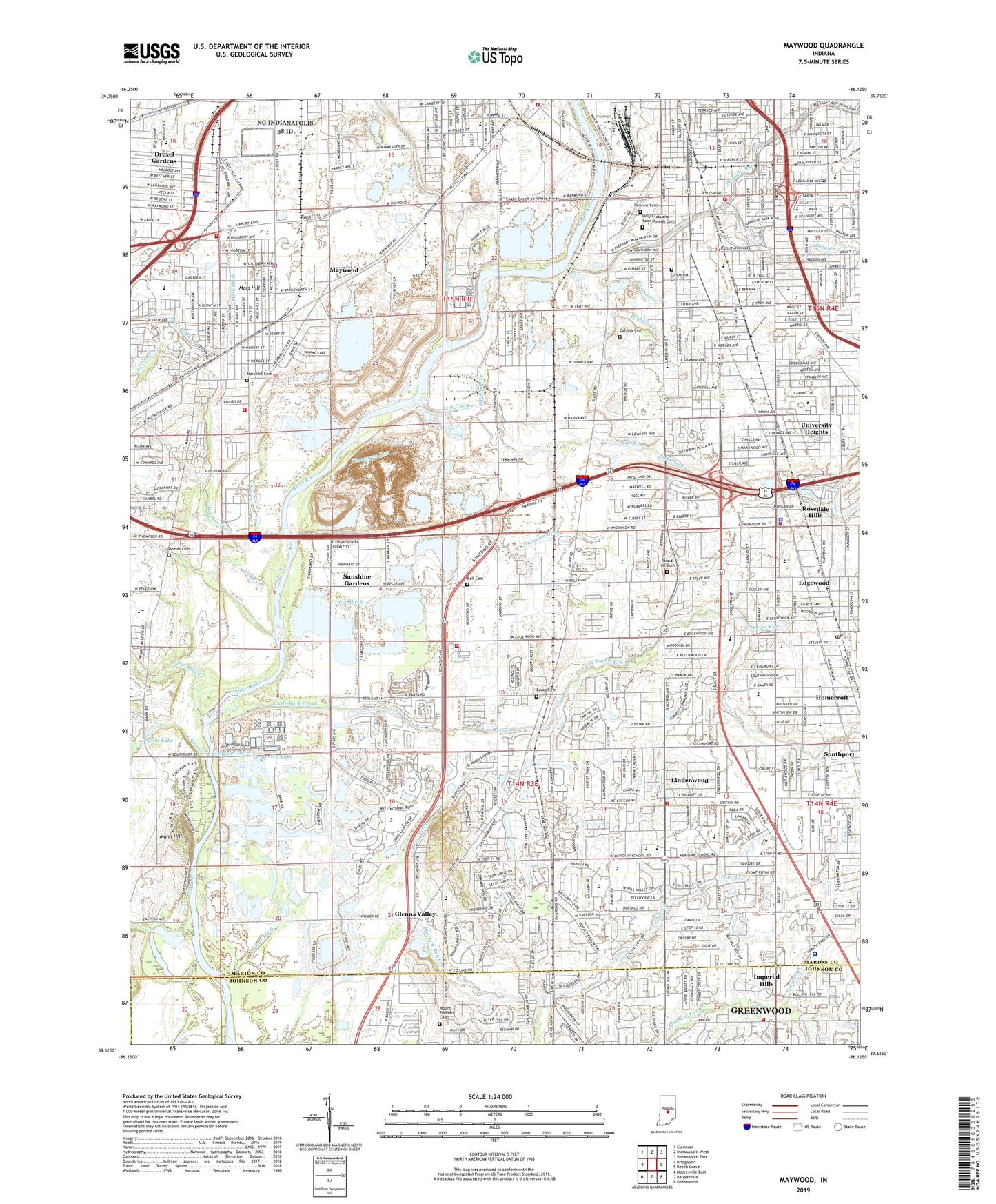
2022 topographic map quadrangle Maywood in the state of Indiana. Scale: 1:24000. Based on the newly updated USGS 7.5' US Topo map series, this map is in the following counties: Marion, Johnson, Morgan. The map contains contour data, water features, and other items you are used to seeing on USGS maps, but also has updated roads and other features. This is the next generation of topographic maps. Printed on high-quality waterproof paper with UV fade-resistant inks.
Quads adjacent to this one:
West: Bridgeport
Northwest: Clermont
North: Indianapolis West
Northeast: Indianapolis East
East: Beech Grove
Southeast: Greenwood
South: Bargersville
Southwest: Mooresville East
This map covers the same area as the classic USGS quad with code o39086f2.
Contains the following named places: Abraham Lincoln Elementary School, Ayr-Way South Shopping Center, Banta Cemetery, Bean Creek, Beeler Cemetery, Bell Cemetery, Belmont Advanced Wastewater Treatment Facility, Blue Lake, Bluff Avenue School, Bluff Park, Brushy Fork, Buffalo Creek, Buffer Park Golf Course, Bureau Baptist Church, Calvary Cemetery, Calvary Lutheran School, Central Hall, Christel DeHaan Fine Arts Center, Churchman Ditch, Columbia Park, Community Hospital South, Concordia Cemetery, Cory Bretz Hall, Country Center Shopping Center, Cravens Hall, Cropsey School Number 22, Daniel Webster Elementary School, Decatur Township Fire Department Station 74, Dollar Hide Creek, Douglas A MacArthur Elementary School, Drexel Gardens, Drexel Run, Eagle Creek, Edgewood, Edgewood School, Eleanor Skillen Elementary School, Eli Lilly and Company Fire Station, Eli Lilly Technology Center, Emergency Medical Ambulance Service, Emmerich Manual High School, Esch Hall, Evens School, Fawn Run, Fountain Creek, Frederick Douglass Elementary School, Friedens United Church of Christ, Garfield Heights Church of Christ, Garfield Park, Garfield Park Baptist Church, Garfield Post Office, Gateway South Business Park, Germania Creek, Glenns Valley, Good Hall, Greenwood Corner Shopping Center, Greenwood Fire Department Station 92, Greenwood Mall, Greenwood Place Shopping Center, Greenwood Point Shopping Center, Greenwood Shoppes Shopping Center, Hapgood Ditch, Harding Street Quarry, Hare Ditch, Harmon Ditch, Harness Ditch, Haueisen Ditch, Hebrew Cemetery, Heidenreich Greenhouses, Highland Creek, Hillenburg Airport, Holy Cross and Saint Joseph Cemetery, Holy Cross Roman Catholic Church, Homecroft, Homecroft Elementary School, Homecroft Police Department, Hope Baptist Church, Hope Chapel, Imperial Hills, Indiana Bible College, Indianapolis Baptist Temple, Indianapolis Fire Department Station 23, Indianapolis Fire Department Station 26, Indianapolis Fire Department Station 29, Indianapolis Fire Department Station 34, Indianapolis Fire Department Support Services, James A Garfield Elementary School, Kentucky Avenue Mine, Key Stadium, Krannert Memorial Library, Le-An-Wa Lake, Lick Creek, Lillian M Reiffel Elementary School, Lilly Recreation Park, Lilly Science Hall, Lincoln School, Lindenwood, Little Buck Creek, Little Mann Creek, Longacre Park, Lowman Creek, Madison Square Shopping Center, Mann Creek, Mann Hill, Maple Grove School, Mars Hill, Mars Hill Cemetery, Martin Hall, Marwood Southern Baptist Church, Maywood, McCarty School Number 48, McClainsville School, Meridian Church of God, Meridian Meadows Shopping Center, Meridian Woods Baptist Church, Meridian Woods Park, Mickley Run, Mount Pleasant Cemetery, Mount Pleasant Church, New Hall, Oak Park Baptist Church, Orme Ditch, Otis E Brown Elementary School, Perry Central Junior High School, Perry Park, Peyton Lake, Pleasant Run, Pond Branch, Ransburg Auditorium, Raymond F Brandes Elementary School, Resurrection Lutheran Church, Riley School, Rolls - Royce Fire Department, Rosedale Hills, Round Hill Cemetery, Ruth Lilly Center, Sacred Heart High School, Sacred Heart of Jesus Roman Catholic Church, Saint Ann Roman Catholic Church, Saint Ann School, Saint Barnabas Roman Catholic Church, Saint Barnabas School, Saint Catherine Roman Catholic Church, Saint Catherines School, Saint James School, Saint James the Greater Roman Catholic Church, Saint Mark Roman Catholic Church, Saint Mark School, Saint Pauls School, Saint Roch Roman Catholic Church, Saint Roch School, Sanders Elementary School, School Number 13, Schwitzer Student Center, Seerley Creek, Shannon Lake, Shelby Branch Indianapolis-Marion County Public Library, Smith Mall, South 31 Shopping Center, South Village Plaza Shopping Center, South Westway Park, Southern Dunes Golf Course, Southern Plaza Shopping Center, Southgate Plaza Shopping Center, Southport, Southport Advanced Wastewater Treatment Plant, Southport Centre Shopping Center, Southport High School, Southport Plaza Shopping Center, Southport Post Office, Southport United Methodist Church, Southwood Assembly of God Church, State Ditch, Stephen Decatur Elementary School, Stierwalt Alumni House, Stout Field, Stout Field Park, Suburban Baptist Church, Sunnyside Post Office, Sunshine Gardens, Swamp Creek, Tallwood Chapel, Temple Baptist Church, Thompson Road Independent Baptist Church, Thompson Run, Town of Homecroft, Township of Perry, Union Stockyards, University Heights, University Heights Hospital, University Heights Independent Christian Church, University Heights School, University of Indianapolis, Villa Baptist Church, Warren Hall, WATI-AM (Indianapolis), Wayne Township Fire Department Station 81, WIFE-AM (Indianapolis), William Henry Burkhart Elementary School, Winding River Golf Course, Zerfas Wing (Lilly Hall), ZIP Codes: 46217, 46221, 46225, 46227