MyTopo
Ames East Iowa US Topo Map
Couldn't load pickup availability
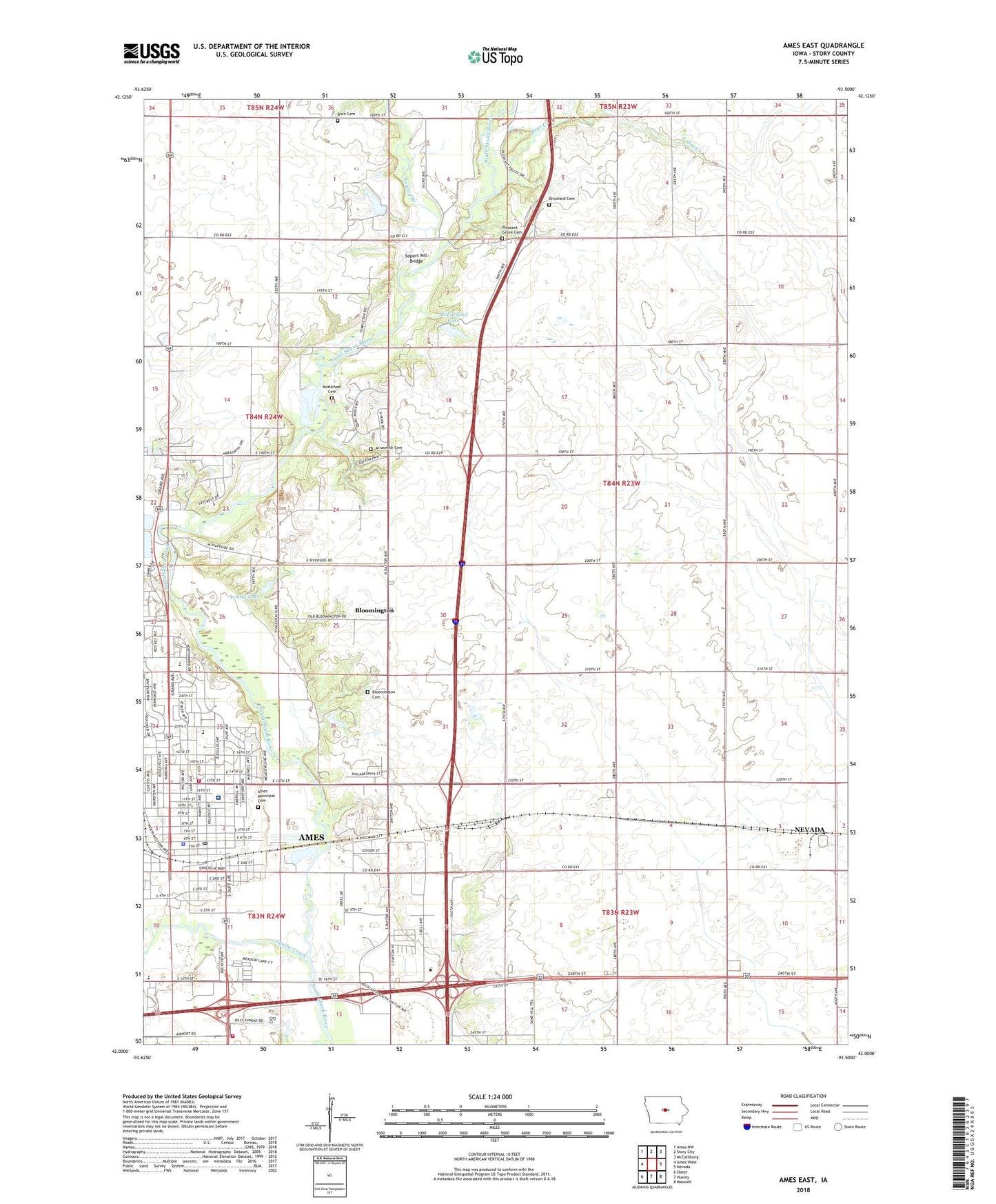
2023 topographic map quadrangle Ames East in the state of Iowa. Scale: 1:24000. Based on the newly updated USGS 7.5' US Topo map series, this map is in the following counties: Story. The map contains contour data, water features, and other items you are used to seeing on USGS maps, but also has updated roads and other features. This is the next generation of topographic maps. Printed on high-quality waterproof paper with UV fade-resistant inks.
Quads adjacent to this one:
West: Ames West
Northwest: Ames NW
North: Story City
Northeast: McCallsburg
East: Nevada
Southeast: Maxwell
South: Huxley
Southwest: Slater
This map covers the same area as the classic USGS quad with code o42093a5.
Contains the following named places: Abington on Grand Center, Ames, Ames Back and Neck Care Center, Ames Christian School, Ames Church of the Nazarene, Ames Community Church, Ames Fire Department Station 1, Ames Fire Department Station 3, Ames Four Square Church, Ames Jewish Congregation, Ames Mall, Ames Mennonite Church, Ames Mine, Ames Municipal Cemetery, Ames Oral Surgeons Center, Ames Pathology Center, Ames Police Department, Ames Post Office, Ames Public Library, Ames Seventh Day Adventist Church, Arnold Lake, Arnold Lake Dam, Arrasmith Cemetery, Ascension Lutheran Church, Bandshell Park, Bear Creek, Beardshear School, Bliss Cancer Center, Bloomington, Bloomington Cemetery, Born Cemetery, Brouhard Cemetery, Camden Post Office, Camp Canwita, Campus Baptist Church, Carr Park, Central Junior High School, Christ Apostolic Faith Temple, City of Ames, Cornerstone Church of Ames, Department of Corrections Curt Forbes Residential Center, Doran Clinic for Women, Dry Creek, Duff Park, Duplicate Sun Dial of Plymouth Colony Historical Marker, First Assembly of God Church, First Christian Church, First Church of Christ Scientist, First United Methodist Church, Friends Meeting, Grand Avenue Baptist Church, Heartland Baptist Church, Homewood Golf Course, Inis Grove Park, Iowa Heart Center, Iowa State University Experimental Farm, Ioway Creek, Izaak Walton League Park, Keigley Branch, Kingdom Hall of Jehovahs Witnesses, Korean United Methodist Church, Lincoln School, Lord of Life Lutheran Church, Mary Greeley Medical Center, McDonald Woods, McFarland Clinic, McFarland Lake, McFarland Lake Dam, McFarland Lake Park, McMichael Cemetery, Meadow Lane Mobile Home Park, Meeker Elementary School, Mifford Consolidated School, New Life United Pentecostal Church, North Grand Church of Christ, North Grand Mall, Northwood Preschool Center, Oaks Golf Course, Old Towne Park, O'Neil Park, Peterson Pits Recreation Area, Pleasant Grove Cemetery, Pleasant Grove Church, Prairie View Golf Course, River Valley Park, Roosevelt School, Saint Cecilia School, Saint Paul Lutheran Church, Shady Grove Mobile Home Park, Site of the First House in Ames Historical Marker, Sopers Mill Access Area, Sopers Mill Bridge, South Valley River Park, Squaw Creek Park, State of Iowa, Story Center Historical Museum, Story City South Bound Rest Area, Story County Conservation Center, Sunday Cemetery, Tom Evans Park, Township of Milford, United Church of Christ, Unity Church of Ames, Wilson School, Worrell Creek, ZIP Code: 50010