MyTopo
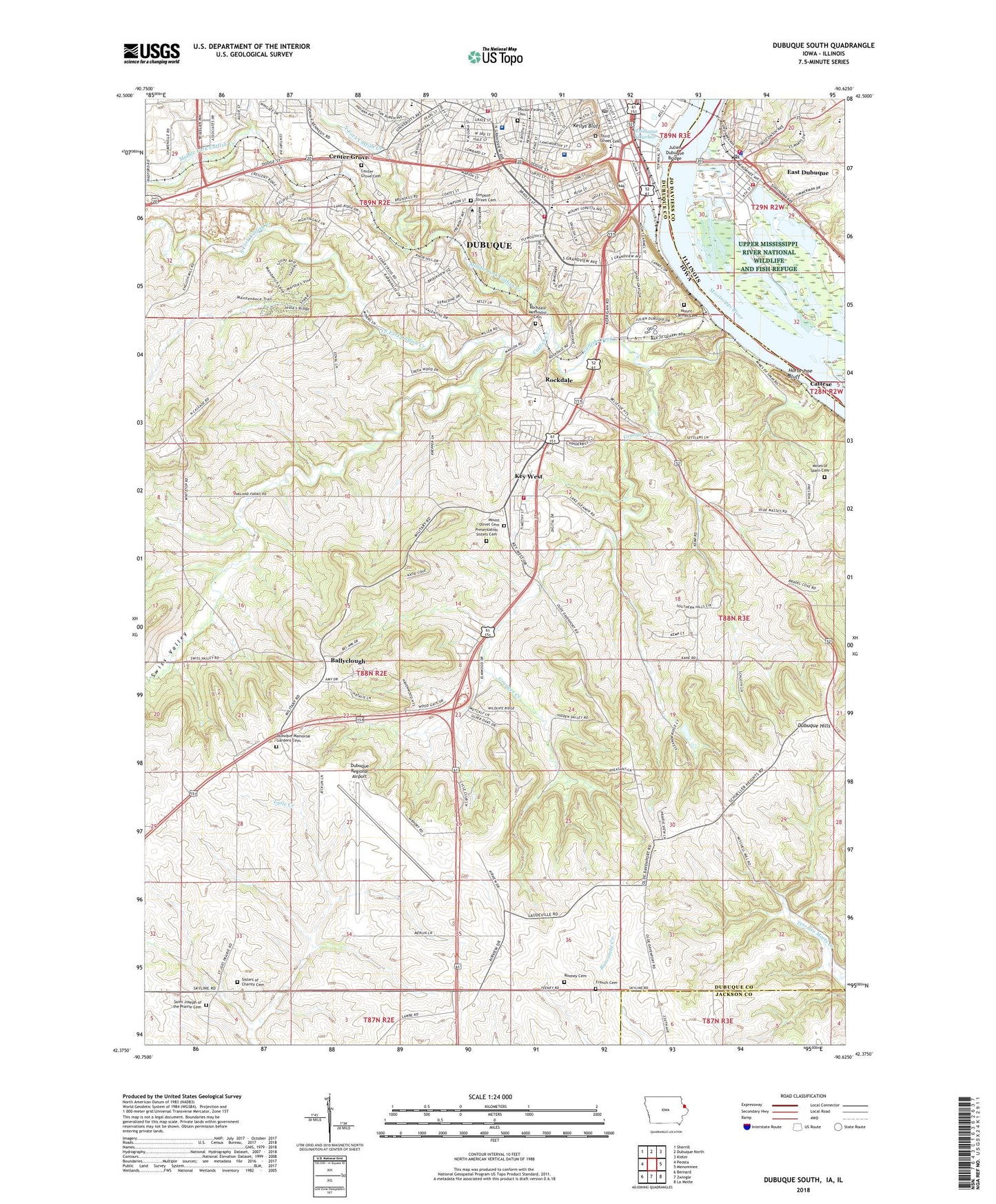
Dubuque South Iowa US Topo Map
Couldn't load pickup availability
2022 topographic map quadrangle Dubuque South in the states of Iowa, Illinois. Scale: 1:24000. Based on the newly updated USGS 7.5' US Topo map series, this map is in the following counties: Dubuque, Jo Daviess, Jackson. The map contains contour data, water features, and other items you are used to seeing on USGS maps, but also has updated roads and other features. This is the next generation of topographic maps. Printed on high-quality waterproof paper with UV fade-resistant inks.
Quads adjacent to this one:
West: Peosta
Northwest: Sherrill
North: Dubuque North
Northeast: Kieler
East: Menominee
Southeast: La Motte
South: Zwingle
Southwest: Bernard
Contains the following named places: Ace Mobile Home Park, Advancement Offices, Aitchison Residence Hall, Alumni Hall, Baehler Cemetery, Ballyclough, Ballyclough Post Office, Bluff Side Park, Bryant Elementary School, Buncombe, Caledonia Park, Cassett Residence Hall, Catfish Creek, Catfish Creek State Preserve, Cathedral Square, Cattese, Center Grove, Center Grove Cemetery, Center Grove Post Office, Central Alternative High School, Chalmers Field, Charles C Myers Library, Chlapaty Sports Complex, Christman School, Church of the Nazarene, City of East Dubuque, Cog Railway Elevator Historical Marker, Doctor Finleys Cemetery, Donnell Residence Hall, Dubugue Harbor, Dubuque Country Club, Dubuque Emergency Physicians Center, Dubuque Family Practice Center, Dubuque Fire Department Station 4, Dubuque Fire Department Station 5, Dubuque Friends Worship Group, Dubuque Harbor, Dubuque Hills, Dubuque Internal Medicine Center, Dubuque Memorial Gardens Cemetery, Dubuque Museum of Art, Dubuque Neurology Center, Dubuque Obstetrics and Gynocology Center, Dubuque Pediatrics Center, Dubuque Post Office, Dubuque Regional Airport, Dubuque Rescue Mission, Dubuque's Old Shot Tower Historical Marker, E B Lyons Nature Center, E B Lyons Prairie-Woodlawn Preserve, East Dubuque, East Dubuque Fire Department Station 1, East Dubuque Fire Department Station 2, East Dubuque High School, East Dubuque Police Department, East Dubuque Post Office, East Dubuque School, FDR Park, Fenelon Place Elevator, Finley Hospital Heliport, Floodwall Trail - South Section, French Cemetery, Goldthorp Science Hall, Grandview Avenue Church, Grandview Heights Baptist Church, Granger Creek, Heartland Emergency Medical Service, Heat Plant, Holy Trinity Lutheran Church, Horseshoe Bluff, Husemanns RV Park and Campgrounds, Irving Elementary School, Jackaline Baldwin Dunlap Technology Center, Jackson County Hospital, Julien Dubuque Bridge, Julien Dubuque Monument, KDTH-AM (Dubuque), Kellys Bluff, Kemp School, Kennedy Mall, Key West, Key West Fire Department, Keywest Post Office, Lacoma Golf Course, Lake Eleanor Dam, Lincoln Elementary School, Louis Murphy Park, Mades Hall, Maintenance and Custodial Offices, McCormick Gymnasium, Medical Associates Clinic, Mercy Health Center Heliport, Mercy Medical Center Dubuque, Middle Fork Catfish Creek, Mid-Town Marina, Mines of Spain, Mines of Spain Cemetery, Mines of Spain State Park, Mount Carmel Convent, Mount Olivet Cemetery, National Mississippi River Museum, National River Hall of Fame, North Cascade School, North Fork Catfish Creek, Old Shot Tower, Origin of Old Military Road Historical Marker, Paramount Emergency Medical Services, Peters Commons, Port of Dubuque Iowa Welcome Center, Potterweld Apartments, Prairie Springs Post Office, Presentation Sisters Cemetery, Rafferty Field, Rock of Ages Chapel, Rockdale, Rockdale Cemetery, Rockdale Church, Rockdale Post Office, Rooney Cemetery, Saint Columbkille Elementary School, Saint Columbkilles Catholic Church, Saint Joseph, Saint Joseph Church, Saint Joseph of the Prairie Cemetery, Saint Joseph School, Saint Joseph the Worker Church, Saint Raphaels Cathedral, Saint Thomas of Canterbury Church, Salem School, Security Office, Severance Hall, Simpson Street Cemetery, Sisters of Charity Cemetery, Smith Hall, Smith School, South Fork Catfish Creek, South Switch Junction, Steffens Colonnade, Stoltz Sports Center, Swiss Valley, Table Mound Elementary School, Table Mound Mobile Home Park, Temple Beth El, The Church of Jesus Christ of Latter-Day Saints, Third Street Cemetery, Town Clock - 108 Feet High Historical Marker, Town Clock Plaza, Township of Table Mound, Tri-State Surgery Center, Twin T Mobile Home Park, United Community Ministries, Unity Point Health Finley Hospital, University Community Living Center, University of Dubuque, University of Iowa Health Care Center, Van Vliet Hall, Waller School, Warren Plaza, Wartburg Theological Seminary, Washington Middle School, Washington Park, Wendt Regional Cancer Center, Westminster Presbyterian Church, William C Laube Memorial Bell Tower, William M Black Museum, Word of Life Church, ZIP Code: 52003