MyTopo
Hays South Kansas US Topo Map
Couldn't load pickup availability
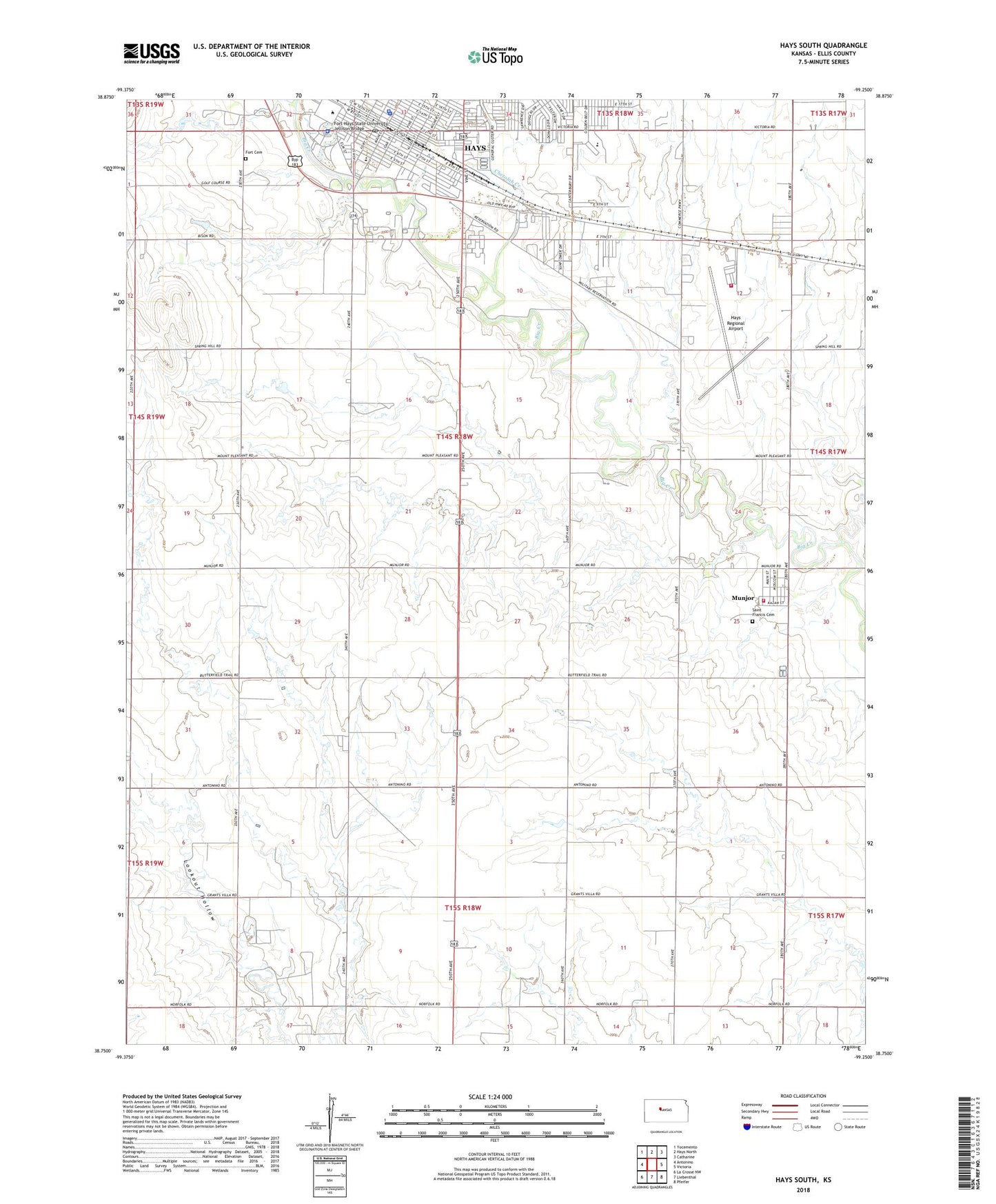
2022 topographic map quadrangle Hays South in the state of Kansas. Scale: 1:24000. Based on the newly updated USGS 7.5' US Topo map series, this map is in the following counties: Ellis. The map contains contour data, water features, and other items you are used to seeing on USGS maps, but also has updated roads and other features. This is the next generation of topographic maps. Printed on high-quality waterproof paper with UV fade-resistant inks.
Quads adjacent to this one:
West: Antonino
Northwest: Yocemento
North: Hays North
Northeast: Catharine
East: Victoria
Southeast: Pfeifer
South: Liebenthal
Southwest: La Crosse NW
This map covers the same area as the classic USGS quad with code o38099g3.
Contains the following named places: 8th and Vine, A Bar S Ranch, Agape Southern Baptist Church, Airport Park, Buffalo Hills Mobile Home Park, Chetolah Creek, Cottonwood Mobile Home Park, Countryside Mobile Home Estates, Custer Island Park, Ekey Park, Ellis County Courthouse, Ellis County Health Department, Ellis County Highway Department, Ellis County Historical Society Museum, Ellis County Jail, Ellis County Rural Fire Department 5, Ellis County Rural Fire Department 9, Ellis County Sheriff's Office, First Baptist Church, First United Methodist Church of Hays, Fort Cemetery, Fort Hays Municipal Golf Course, Fort Hays State University, Fort Hays State University Agnew Hall, Fort Hays State University Akers Energy Center, Fort Hays State University Albertson Hall, Fort Hays State University Cunningham Hall, Fort Hays State University Custer Hall, Fort Hays State University Davis Hall, Fort Hays State University Forsythe Library, Fort Hays State University Gross Memorial Coliseum, Fort Hays State University Jellison Bridge, Fort Hays State University Lewis Field Stadium, Fort Hays State University Malloy Hall, Fort Hays State University Martin Allen Hall, Fort Hays State University McCartney Hall, Fort Hays State University McMindes Hall, Fort Hays State University Memorial Union, Fort Hays State University Picken Hall, Fort Hays State University Police Department, Fort Hays State University President's Residence, Fort Hays State University Rarick Hall, Fort Hays State University Robbins Center, Fort Hays State University Rodeo Arena, Fort Hays State University Sheridan Hall, Fort Hays State University Stroup Hall, Fort Hays State University Tomanek Hall, Fort Hays State University Wiest Hall, Fort Hays Trailer Park, Frank Stramel Baseball Fields, Frontier Park, Hadley Hospital, Hays Aquatic Park, Hays Church of the Nazarene, Hays Fire Department - Airport Station, Hays High School, Hays Police Department, Hays Post Office, Hays Public Library, Hays Recreation Center, Hays Regional Airport, Hays Wastewater Treatment Plant, Hays Water Plant, Kansas Department of Wildlife and Parks Region 1 Headquarters, Kansas National Guard Armory Hays, Kansas State University Agricultural Research Center Hays, Kingdom Hall of Jehovah's Witnesses, Kiwanis Park, Larks Park, Liberty Christian Fellowship, Massey Park, Municipal Park, Munjor, Munjor Census Designated Place, Munjor Elementary School, Old Fort Hays, Old Fort Hays Museum, Pratt Optimist Soccer Park, Rockwell Administration Center, Saint Francis Cemetery, Saint Francis of Assisi Catholic Church, Saint Nicholas of Myra Catholic Church, Speier Ballpark, Stecklein Field, Township of Big Creek, Township of Wheatland, Union Pacific Park, Washington Elementary School