MyTopo
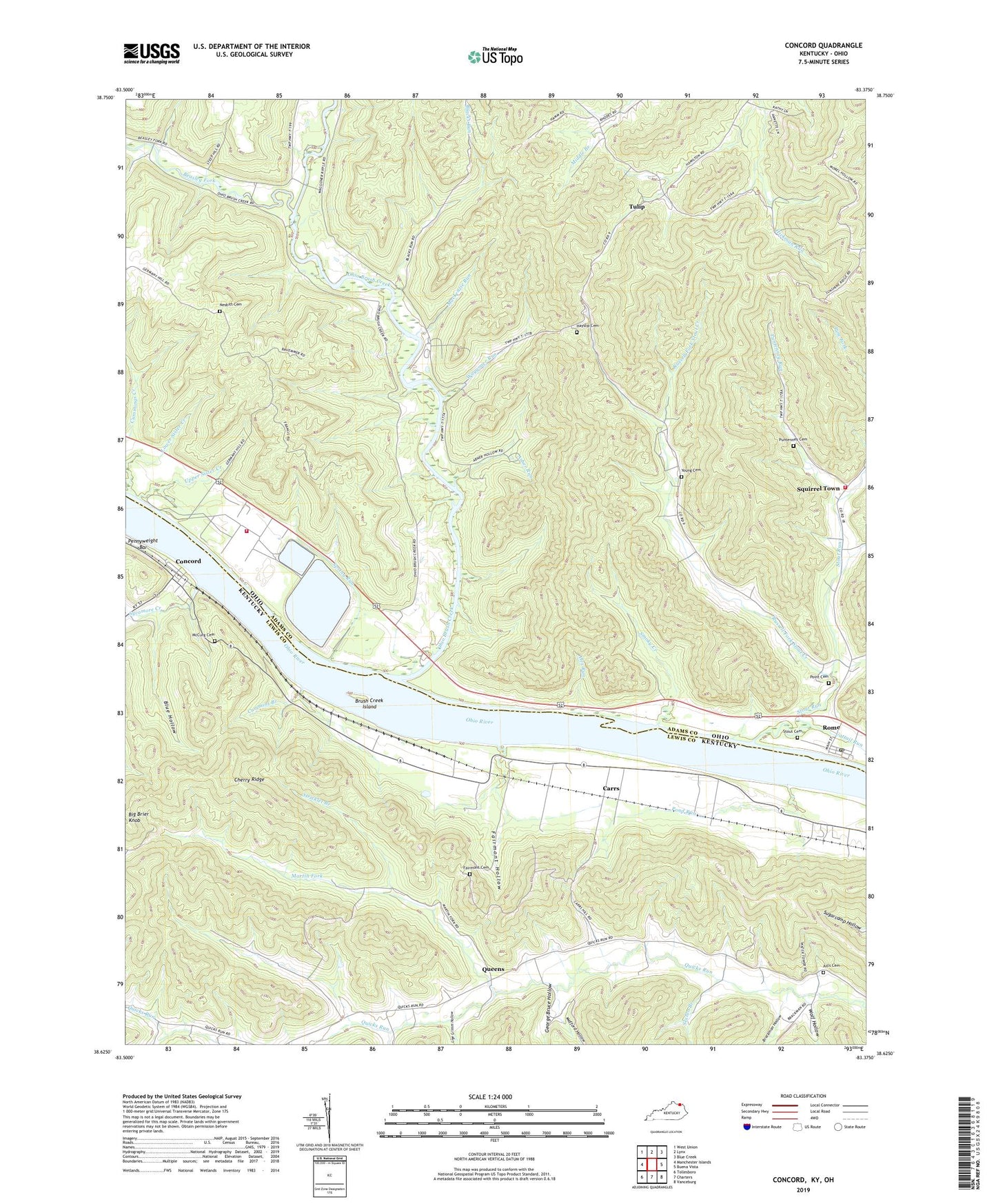
Concord Kentucky US Topo Map
Couldn't load pickup availability
2022 topographic map quadrangle Concord in the states of Ohio, Kentucky. Scale: 1:24000. Based on the newly updated USGS 7.5' US Topo map series, this map is in the following counties: Lewis, Adams. The map contains contour data, water features, and other items you are used to seeing on USGS maps, but also has updated roads and other features. This is the next generation of topographic maps. Printed on high-quality waterproof paper with UV fade-resistant inks.
Quads adjacent to this one:
West: Manchester Islands
Northwest: West Union
North: Lynx
Northeast: Blue Creek
East: Buena Vista
Southeast: Vanceburg
South: Charters
Southwest: Tollesboro
Contains the following named places: Abner Hollow Cincinnati Museum of Natural History Nature Preserve, Aills Cemetery, Alex Run, Asher Run, Badfords Landing, Beasley Fork, Beasley Fork Chapel, Beasley Fork School, Blacks Run, Blue Hollow, Brackman Hollow, Brush Creek Island, Carrs, Carrs Church, Carrs Post Office, Carrs School, Cattail Run, Cave Hollow, Cedar College School, Chalkley Station, Cherry Ridge, Cincinnati Museum of Natural History Nature Preserve, City of Concord, City of Rome, Concord, Concord Post Office, Cummings Creek, Cummins Branch, Dayton Power and Light - Killen Electric Generating Station Fire Department, East Gift Ridge Church, Fairmont Cemetery, Fairmont Hollow, Gemmer, George Bruce Hollow, Green Elementary School, Green Hollow, Green Township Fire Department, Greenhow Branch, Grimes, Grimes Landing, Grimes Post Office, Hayslip Cemetery, Hut Hollow, J Montieth Landing, Jacktown Post Office, Jerry Ellis Landing, Lige Grimm Hollow, Lockhart Landing, Lower Sister Creek, Mackenzie Run, Manyopper Landing, Martin Church, Martin Fork, Martin School, Martins Fork Christian Church, Martins Fork Post Office, McCurg Cemetery, McGovney School, McKee Hollow, Mefford Hollow, Mitchell Lake, Morrison Hollow, Mount Tabor School, Muses Chapel, Nesbitt Cemetery, Nesbitt School, Ohio Brush Creek, Ohio Brush Creek Boat Launch Ramp, Oil Hollow, Pennyweight Bar, Point Cemetery, Pond Run, Pool Branch, Pugh Post Office, Puntenney Cemetery, Puntenney Run, Queens, Red Rock Cincinnati Museum of Natural History Nature Preserve, Rome Boat Launch Ramp, Rome Station, Russell Fork Stout Creek, Russell School, Sexton Branch, Smoky Creek, Spring Run, Squirrel Town, Station Landing Post Office, Stevensons Landing, Stout, Stout Cemetery, Stout Post Office, Stout Run, Stouts Landing, Stouts Landing Post Office, Stricklet Branch, Sycamore Creek, Thompson Hollow, Tracey Run, Truitt Hollow, Tulip, Tulip Post Office, Upper Sister Creek, Village of Rome, W Montieth Landing, Waggoner Ripple, Waggoner Ripple Church, Waggoner Ripple Post Office, Waggoner Run, Wolf Hollow, Young Cemetery, ZIP Code: 45650